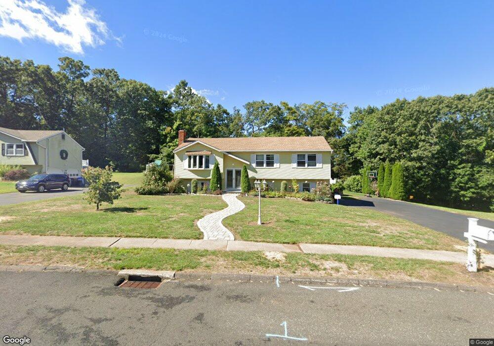
70 Christine Dr Southington, CT 06489
East Southington NeighborhoodEstimated Value: $470,516 - $537,000
3
Beds
3
Baths
1,348
Sq Ft
$362/Sq Ft
Est. Value
About This Home
This home is located at 70 Christine Dr, Southington, CT 06489 and is currently estimated at $488,629, approximately $362 per square foot. 70 Christine Dr is a home located in Hartford County with nearby schools including Derynoski Elementary School, John F. Kennedy Middle School, and Southington High School.
Ownership History
Date
Name
Owned For
Owner Type
Purchase Details
Closed on
Nov 21, 2006
Sold by
Casey Richard and Casey Shirley
Bought by
Davino Lynn M and Vargas Rafael
Current Estimated Value
Home Financials for this Owner
Home Financials are based on the most recent Mortgage that was taken out on this home.
Original Mortgage
$256,500
Outstanding Balance
$151,956
Interest Rate
6.33%
Estimated Equity
$336,673
Purchase Details
Closed on
Mar 31, 2004
Sold by
Hanson John H and Hanson Linda
Bought by
Casey Richard and Casey Shirley
Home Financials for this Owner
Home Financials are based on the most recent Mortgage that was taken out on this home.
Original Mortgage
$193,256
Interest Rate
4.5%
Purchase Details
Closed on
Nov 16, 1990
Sold by
Certisimo Edward
Bought by
Hanson John
Create a Home Valuation Report for This Property
The Home Valuation Report is an in-depth analysis detailing your home's value as well as a comparison with similar homes in the area
Home Values in the Area
Average Home Value in this Area
Purchase History
| Date | Buyer | Sale Price | Title Company |
|---|---|---|---|
| Davino Lynn M | $285,000 | -- | |
| Casey Richard | $238,000 | -- | |
| Hanson John | $186,000 | -- |
Source: Public Records
Mortgage History
| Date | Status | Borrower | Loan Amount |
|---|---|---|---|
| Open | Hanson John | $25,000 | |
| Open | Hanson John | $256,500 | |
| Previous Owner | Hanson John | $193,256 | |
| Previous Owner | Hanson John | $145,000 |
Source: Public Records
Tax History Compared to Growth
Tax History
| Year | Tax Paid | Tax Assessment Tax Assessment Total Assessment is a certain percentage of the fair market value that is determined by local assessors to be the total taxable value of land and additions on the property. | Land | Improvement |
|---|---|---|---|---|
| 2025 | $7,242 | $218,080 | $66,050 | $152,030 |
| 2024 | $6,856 | $218,080 | $66,050 | $152,030 |
| 2023 | $6,621 | $218,080 | $66,050 | $152,030 |
| 2022 | $6,353 | $218,080 | $66,050 | $152,030 |
| 2021 | $6,331 | $218,080 | $66,050 | $152,030 |
| 2020 | $5,988 | $195,500 | $67,410 | $128,090 |
| 2019 | $5,962 | $194,570 | $67,410 | $127,160 |
| 2018 | $5,930 | $194,570 | $67,410 | $127,160 |
| 2017 | $5,930 | $194,570 | $67,410 | $127,160 |
| 2016 | $5,767 | $194,570 | $67,410 | $127,160 |
| 2015 | $5,695 | $195,440 | $64,200 | $131,240 |
| 2014 | $5,543 | $195,440 | $64,200 | $131,240 |
Source: Public Records
Map
Nearby Homes
- 18 Birchcrest Dr
- 24 Hemlock Dr
- 35 Heritage Dr
- 241 Pondview Dr
- 152 Old Turnpike Rd
- 36 Buckland St Unit 22
- 308 Bristol St
- 78 Homesdale Ave
- 785 Old Turnpike Rd
- 310 Buckland St Unit Rear
- 103 Milldale Ave
- 42 Vermont Ave
- 65 Bristol St
- 100 Berlin St
- 30 Prosperity Ct Unit 8
- 20 Milldale Ave
- 7 Zwicks Farm Rd
- 997 Meriden Ave
- 194 W Center St
- 20 Wolf Hill Rd