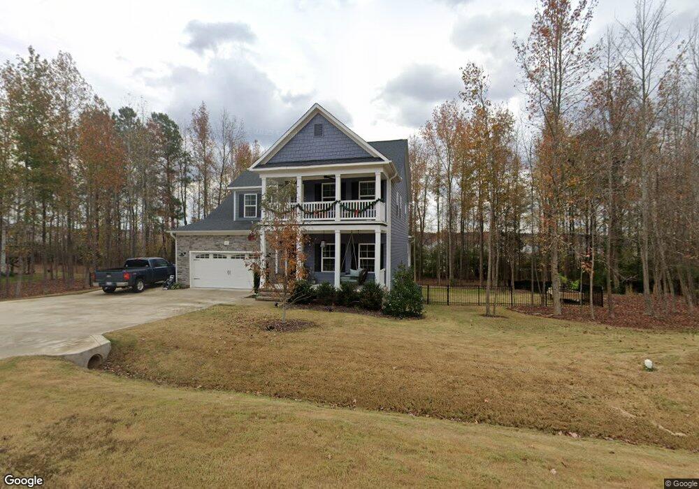
70 E Houndstoothe Ct Clayton, NC 27520
Estimated Value: $530,907 - $582,000
4
Beds
3
Baths
3,162
Sq Ft
$175/Sq Ft
Est. Value
About This Home
This home is located at 70 E Houndstoothe Ct, Clayton, NC 27520 and is currently estimated at $554,227, approximately $175 per square foot. 70 E Houndstoothe Ct is a home with nearby schools including West Clayton Elementary School, Clayton Middle School, and Clayton High.
Ownership History
Date
Name
Owned For
Owner Type
Purchase Details
Closed on
Nov 26, 2021
Sold by
Caviness & Cates Building And Dev Co
Bought by
Hutchins Wesley O and Hutchins Amanda E
Current Estimated Value
Home Financials for this Owner
Home Financials are based on the most recent Mortgage that was taken out on this home.
Original Mortgage
$367,269
Outstanding Balance
$337,927
Interest Rate
3.14%
Mortgage Type
New Conventional
Estimated Equity
$216,300
Purchase Details
Closed on
Jul 28, 2020
Sold by
Asco Builders Inc
Bought by
Ais Forestry & Farming Llc
Purchase Details
Closed on
Jul 22, 2020
Sold by
Stewart Michael L
Bought by
Stone Street Builders Llc
Create a Home Valuation Report for This Property
The Home Valuation Report is an in-depth analysis detailing your home's value as well as a comparison with similar homes in the area
Home Values in the Area
Average Home Value in this Area
Purchase History
| Date | Buyer | Sale Price | Title Company |
|---|---|---|---|
| Hutchins Wesley O | $459,500 | None Available | |
| Ais Forestry & Farming Llc | $915,000 | None Available | |
| Stone Street Builders Llc | $2,108,000 | None Available |
Source: Public Records
Mortgage History
| Date | Status | Borrower | Loan Amount |
|---|---|---|---|
| Open | Hutchins Wesley O | $367,269 |
Source: Public Records
Tax History Compared to Growth
Tax History
| Year | Tax Paid | Tax Assessment Tax Assessment Total Assessment is a certain percentage of the fair market value that is determined by local assessors to be the total taxable value of land and additions on the property. | Land | Improvement |
|---|---|---|---|---|
| 2025 | $3,616 | $569,410 | $80,000 | $489,410 |
| 2024 | $2,963 | $365,860 | $45,000 | $320,860 |
| 2023 | $3,073 | $365,860 | $45,000 | $320,860 |
| 2022 | $3,043 | $359,030 | $45,000 | $314,030 |
| 2021 | $381 | $45,000 | $45,000 | $0 |
Source: Public Records
Map
Nearby Homes
- 217 Shooting Star Ln
- 85 W Tecoma Ln
- 77 Redpine Ct
- 315 Sugarpine Trail
- 20 Sugarpine Trail
- 176 Red Jasper Way
- 154 Red Jasper Way
- 142 Red Jasper Way
- 166 Red Jasper Way
- BENNETT Plan at Winston Pointe - The Manors at Winston Pointe
- Hartwell Plan at Winston Pointe - The Grove at Winston Pointe
- Jordan Plan at Winston Pointe - The Grove at Winston Pointe
- Hampshire Plan at Winston Pointe - The Grove at Winston Pointe
- Wylie Plan at Winston Pointe - The Grove at Winston Pointe
- Norman Plan at Winston Pointe - The Grove at Winston Pointe
- 1074 Carlton St
- 718 Winston Rd
- 2579 Valley Dr
- 54 E Fire Opal Ct
- 49 W Fire Opal Ct
- 48 E Houndstoothe Ct
- 120 E Houndstoothe Ct
- 440 W Cannalily Ln
- 103 E Tecoma Ln
- LOT2 Winston Rd
- LOT1 Winston Rd
- 127 E Houndstoothe Ct
- 101 E Tecoma Ln
- 117 E Tecoma Ln
- 87 E Tecoma Ln
- 95 E Tecoma Ln
- 125 E Tecoma Ln
- 75 E Tecoma Ln
- 133 E Tecoma Ln
- 118 E Tecoma Ln
- 104 E Tecoma Ln
- 96 E Tecoma Ln
- 141 E Tecoma Ln
- 65 E Tecoma Ln
- 501 Lower Winston Pkwy