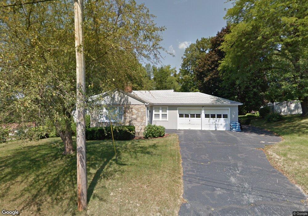
70 Eastwood Rd Shrewsbury, MA 01545
Estimated Value: $494,000 - $593,000
3
Beds
2
Baths
1,384
Sq Ft
$398/Sq Ft
Est. Value
About This Home
This home is located at 70 Eastwood Rd, Shrewsbury, MA 01545 and is currently estimated at $551,002, approximately $398 per square foot. 70 Eastwood Rd is a home located in Worcester County with nearby schools including Walter J. Paton Elementary School, Sherwood Middle School, and Oak Middle School.
Ownership History
Date
Name
Owned For
Owner Type
Purchase Details
Closed on
Oct 1, 2019
Sold by
Ohara Henry T
Bought by
Ohara Henry T and Samuelson Marilyn K
Current Estimated Value
Purchase Details
Closed on
Jun 27, 2013
Sold by
Ohara Henry T
Bought by
Diverdi Builders Inc
Purchase Details
Closed on
Sep 8, 1989
Sold by
Englund Mildred
Bought by
Ohara Henry
Home Financials for this Owner
Home Financials are based on the most recent Mortgage that was taken out on this home.
Original Mortgage
$128,000
Interest Rate
9.71%
Mortgage Type
Purchase Money Mortgage
Create a Home Valuation Report for This Property
The Home Valuation Report is an in-depth analysis detailing your home's value as well as a comparison with similar homes in the area
Home Values in the Area
Average Home Value in this Area
Purchase History
| Date | Buyer | Sale Price | Title Company |
|---|---|---|---|
| Ohara Henry T | -- | -- | |
| Ohara Henry T | -- | -- | |
| Ohara Henry T | -- | -- | |
| Diverdi Builders Inc | $151,000 | -- | |
| Ohara Henry | $160,000 | -- |
Source: Public Records
Mortgage History
| Date | Status | Borrower | Loan Amount |
|---|---|---|---|
| Previous Owner | Ohara Henry | $128,000 |
Source: Public Records
Tax History Compared to Growth
Tax History
| Year | Tax Paid | Tax Assessment Tax Assessment Total Assessment is a certain percentage of the fair market value that is determined by local assessors to be the total taxable value of land and additions on the property. | Land | Improvement |
|---|---|---|---|---|
| 2025 | $61 | $503,800 | $263,700 | $240,100 |
| 2024 | $5,389 | $435,300 | $250,900 | $184,400 |
| 2023 | $5,432 | $414,000 | $250,900 | $163,100 |
| 2022 | $5,699 | $403,900 | $250,900 | $153,000 |
| 2021 | $4,529 | $343,400 | $200,700 | $142,700 |
| 2020 | $4,185 | $335,600 | $200,700 | $134,900 |
| 2019 | $3,983 | $316,900 | $184,600 | $132,300 |
| 2018 | $3,794 | $299,700 | $177,600 | $122,100 |
| 2017 | $3,630 | $282,900 | $160,800 | $122,100 |
| 2016 | $3,678 | $282,900 | $150,900 | $132,000 |
| 2015 | $3,759 | $284,800 | $146,700 | $138,100 |
Source: Public Records
Map
Nearby Homes
- 18 Eastwood Rd
- 114 Grafton St
- 9 Arnold Rd
- 13 Kenilworth Rd
- 39 Old Brook Rd
- 36 Francis Ave
- 7 Wesleyan St
- 29 Elma Cir
- 38 Wesleyan St
- 46-50 Wesleyan St
- 515 Main St
- 33 Shady Lane Ave
- 129 Maple Ave
- 60 Harrington Farms Way Unit 60
- 21 Fiske St
- 102 Harrington Farms Way
- 7 Holman Heights Cir
- 129 A-B Maple Ave
- 9 Heritage St
- 25 Harriet Ave
- 64 Eastwood Rd
- 7 Eastwood Rd
- 67 Eastwood Rd
- 14 Hillcrest Ave
- 16 Hillcrest Ave
- 62 Eastwood Rd
- 8 Hillcrest Ave
- 8 Hillcrest Ave Unit 1
- 18 Hillcrest Ave
- 107 Grafton St
- 3 Eastwood Rd
- 105 Grafton St
- 59 Eastwood Rd
- 15 Eastwood Rd
- 101 Grafton St
- 6 Eastwood Rd
- 104 Summer St
- 24 Hillcrest Ave
- 97 Grafton St
- 10 Eastwood Rd