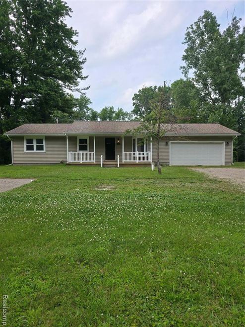
70 Henderson Rd Howell, MI 48855
Howell Township NeighborhoodEstimated Value: $255,000 - $311,000
--
Bed
--
Bath
1,075
Sq Ft
$265/Sq Ft
Est. Value
About This Home
This home is located at 70 Henderson Rd, Howell, MI 48855 and is currently estimated at $284,460, approximately $264 per square foot. 70 Henderson Rd is a home located in Livingston County with nearby schools including Voyager Elementary School, Highlander Way Middle School, and Howell High School.
Ownership History
Date
Name
Owned For
Owner Type
Purchase Details
Closed on
May 18, 2022
Sold by
Spaulding Debra A
Bought by
Lesperance Chris David and Lesperance Kate
Current Estimated Value
Home Financials for this Owner
Home Financials are based on the most recent Mortgage that was taken out on this home.
Original Mortgage
$235,653
Outstanding Balance
$226,470
Interest Rate
5.3%
Mortgage Type
FHA
Estimated Equity
$65,076
Purchase Details
Closed on
Nov 14, 2016
Sold by
Spaulding Barbara M and Spaulding Robert E
Bought by
Spaulding Debra A and Ford Debra A
Create a Home Valuation Report for This Property
The Home Valuation Report is an in-depth analysis detailing your home's value as well as a comparison with similar homes in the area
Home Values in the Area
Average Home Value in this Area
Purchase History
Date | Buyer | Sale Price | Title Company |
---|---|---|---|
Lesperance Chris David | $240,000 | Liberty Title | |
Spaulding Debra A | -- | None Available |
Source: Public Records
Mortgage History
Date | Status | Borrower | Loan Amount |
---|---|---|---|
Open | Lesperance Chris David | $235,653 |
Source: Public Records
Tax History Compared to Growth
Tax History
Year | Tax Paid | Tax Assessment Tax Assessment Total Assessment is a certain percentage of the fair market value that is determined by local assessors to be the total taxable value of land and additions on the property. | Land | Improvement |
---|---|---|---|---|
2024 | $1,430 | $94,047 | $0 | $0 |
2023 | $1,366 | $89,201 | $0 | $0 |
2022 | $1,336 | $80,969 | $0 | $0 |
2021 | $1,311 | $77,400 | $0 | $0 |
2020 | $1,337 | $73,900 | $0 | $0 |
2019 | $1,317 | $69,100 | $0 | $0 |
2018 | $1,303 | $62,300 | $0 | $0 |
2017 | $1,286 | $62,300 | $0 | $0 |
2016 | $1,281 | $59,600 | $0 | $0 |
2014 | $1,245 | $51,600 | $0 | $0 |
2012 | $1,245 | $52,100 | $0 | $0 |
Source: Public Records
Map
Nearby Homes
- 2091 Oak Grove Rd
- 2185 Armond Rd
- 314 Dorchester Dr
- 400 Dorchester Dr
- 323 Dorchester Dr Unit 29
- 1720 Carlisle St
- 1705 Welland St Unit 27
- 1813 Garfield St
- 1635 Welland St Unit 8
- 1734 Town Commons Dr Unit 66
- 407 W Highland Rd Unit A4
- 760 Olde English Cir
- 311 W Highland Rd Unit T13
- 505 W Highland Rd Unit C13
- 1327 Ashebury Ln
- 1319 Ashebury Ln
- 1317 Ashebury Ln
- 221 Victoria Park Ct Unit 17
- 1223 Curzon Ct Unit 201
- 1217 Curzon Ct Unit 203
- 70 Henderson Rd
- 54 Henderson Rd
- 84 Henderson Rd
- 85 Brenda Dr Unit Bldg-Unit
- 85 Brenda Dr
- 98 Henderson Rd
- 88 Brenda Dr
- 000 Henderson Rd
- 110 Henderson Rd
- 51 Henderson Rd
- 2113 Oak Grove Rd
- 125 Brenda Dr
- 126 Henderson Rd
- 2135 Oak Grove Rd
- 100 Brenda Dr
- 2078 Oak Grove Rd
- 2250 Karen Dr
- 2024 Oak Grove Rd
- 2199 Oak Grove Rd
- 141 Brenda Dr