N
Seller's Agent in 2025
Nicole Callahan
Silverstone Capeside Realty Group
(774) 271-1844
4 in this area
78 Total Sales
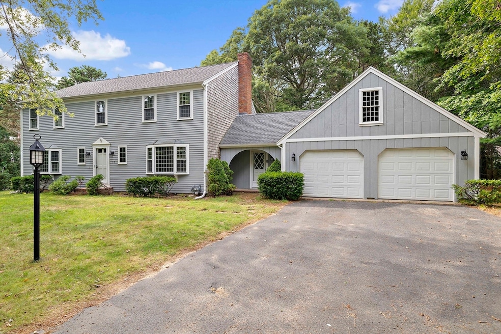


Welcome Home to 70 Joyce Anne Rd! Tucked away at the end of a quiet cul-de-sac, this oversized 4-bedroom Colonial offers privacy, space, and an unbeatable location. Set on a serene, wooded lot, the home features a spacious and flexible floor plan perfect for everyday living and entertaining. Upstairs, you'll find four generously sized bedrooms, including a primary en-suite complete with three closets—plenty of storage and comfort all in one. The main level flows beautifully, with the kitchen easily accessible to both the family room and living room, making gatherings and entertaining a breeze. Most of the home has hardwood flooring. Additional highlights include an attached two-car garage with storage above and the convenience of being just 1.5 miles from the iconic Craigville Beach and South of Route 28. Enjoy the charm of nearby restaurants and local shops, all just minutes away. Don't miss this opportunity to own a slice of Cape Cod tranquility in a prime location!
Last Agent to Sell the Property
Silverstone Capeside Realty Group Listed on: 09/02/2025
| Date | Type | Sale Price | Title Company |
|---|---|---|---|
| Fiduciary Deed | $740,000 | -- | |
| Deed | -- | -- | |
| Deed | -- | -- |
| Date | Status | Loan Amount | Loan Type |
|---|---|---|---|
| Previous Owner | $270,000 | No Value Available | |
| Previous Owner | $250,000 | Purchase Money Mortgage |
| Date | Event | Price | List to Sale | Price per Sq Ft |
|---|---|---|---|---|
| 12/04/2025 12/04/25 | Sold | $740,000 | -12.9% | $295 / Sq Ft |
| 10/16/2025 10/16/25 | Pending | -- | -- | -- |
| 09/22/2025 09/22/25 | Price Changed | $849,900 | -5.6% | $339 / Sq Ft |
| 09/02/2025 09/02/25 | For Sale | $899,900 | -- | $359 / Sq Ft |
| Year | Tax Paid | Tax Assessment Tax Assessment Total Assessment is a certain percentage of the fair market value that is determined by local assessors to be the total taxable value of land and additions on the property. | Land | Improvement |
|---|---|---|---|---|
| 2025 | $6,811 | $841,900 | $258,800 | $583,100 |
| 2024 | $6,315 | $808,600 | $258,800 | $549,800 |
| 2023 | $6,096 | $730,900 | $256,100 | $474,800 |
| 2022 | $5,324 | $552,300 | $164,000 | $388,300 |
| 2021 | $5,507 | $525,000 | $174,300 | $350,700 |
| 2020 | $5,381 | $491,000 | $184,500 | $306,500 |
| 2019 | $5,701 | $505,400 | $194,800 | $310,600 |
| 2018 | $5,175 | $461,200 | $194,300 | $266,900 |
| 2017 | $4,936 | $458,700 | $199,700 | $259,000 |
| 2016 | $5,016 | $460,200 | $201,200 | $259,000 |
| 2015 | $5,451 | $502,400 | $242,400 | $260,000 |
N
Seller's Agent in 2025
Nicole Callahan
Silverstone Capeside Realty Group
(774) 271-1844
4 in this area
78 Total Sales
J
Seller Co-Listing Agent in 2025
John Tamoosh
Silverstone Capeside Realty Group
2 in this area
33 Total Sales
A
Buyer's Agent in 2025
Alessandra Gualberto
All Cape Cod Realty, Inc.
8 in this area
44 Total Sales
Source: MLS Property Information Network (MLS PIN)
MLS Number: 73424625
APN: CENT-000209-000000-000120
Disclaimer: Certain information contained herein is derived from information provided by parties other than Homes.com. All information provided is deemed reliable, but is not guaranteed to be accurate and should be independently verified.
![]() The property listing data and information, or the Images, set forth herein were provided to MLS Property Information Network, Inc. from third party sources, including sellers, lessors and public records, and were compiled by MLS Property Information Network, Inc. The property listing data and information, and the Images, are for the personal, non-commercial use of consumers having a good faith interest in purchasing or leasing listed properties of the type displayed to them and may not be used for any purpose other than to identify prospective properties which such consumers may have a good faith interest in purchasing or leasing. MLS Property Information Network, Inc. and its subscribers disclaim any and all representations and warranties as to the accuracy of the property listing data and information, or as to the accuracy of any of the Images, set forth herein.
The property listing data and information, or the Images, set forth herein were provided to MLS Property Information Network, Inc. from third party sources, including sellers, lessors and public records, and were compiled by MLS Property Information Network, Inc. The property listing data and information, and the Images, are for the personal, non-commercial use of consumers having a good faith interest in purchasing or leasing listed properties of the type displayed to them and may not be used for any purpose other than to identify prospective properties which such consumers may have a good faith interest in purchasing or leasing. MLS Property Information Network, Inc. and its subscribers disclaim any and all representations and warranties as to the accuracy of the property listing data and information, or as to the accuracy of any of the Images, set forth herein.
Ask me questions while you tour the home.
