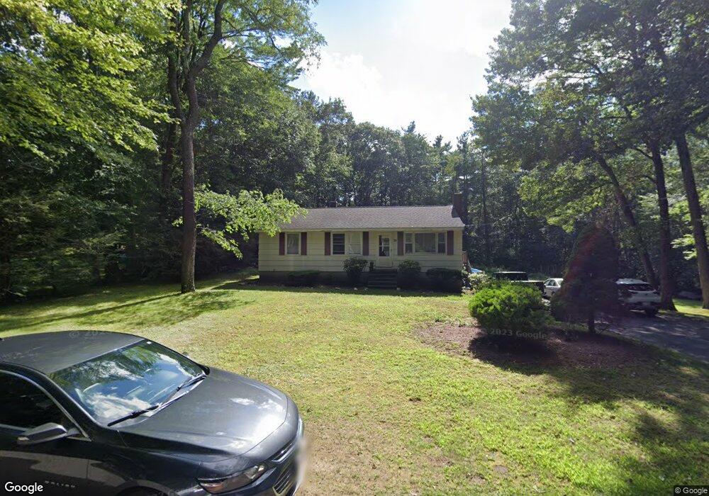
70 Old Broad St Jefferson, MA 01522
Estimated Value: $402,000 - $453,000
3
Beds
2
Baths
1,040
Sq Ft
$413/Sq Ft
Est. Value
About This Home
This home is located at 70 Old Broad St, Jefferson, MA 01522 and is currently estimated at $429,455, approximately $412 per square foot. 70 Old Broad St is a home located in Worcester County with nearby schools including Wachusett Regional High School and Holden Christian Academy.
Ownership History
Date
Name
Owned For
Owner Type
Purchase Details
Closed on
Jul 25, 2008
Sold by
Picard Heather A and Picard Robert J
Bought by
Picard Robert J
Current Estimated Value
Home Financials for this Owner
Home Financials are based on the most recent Mortgage that was taken out on this home.
Original Mortgage
$204,015
Outstanding Balance
$134,032
Interest Rate
6.35%
Mortgage Type
Purchase Money Mortgage
Estimated Equity
$295,423
Purchase Details
Closed on
Jun 1, 1999
Sold by
Ratcliffe Barry K and Ratcliffe Wendy W
Bought by
Picard Robert J and Picard Heather A
Home Financials for this Owner
Home Financials are based on the most recent Mortgage that was taken out on this home.
Original Mortgage
$114,900
Interest Rate
6.82%
Mortgage Type
Purchase Money Mortgage
Create a Home Valuation Report for This Property
The Home Valuation Report is an in-depth analysis detailing your home's value as well as a comparison with similar homes in the area
Home Values in the Area
Average Home Value in this Area
Purchase History
| Date | Buyer | Sale Price | Title Company |
|---|---|---|---|
| Picard Robert J | -- | -- | |
| Picard Robert J | $118,500 | -- |
Source: Public Records
Mortgage History
| Date | Status | Borrower | Loan Amount |
|---|---|---|---|
| Open | Picard Robert J | $204,015 | |
| Previous Owner | Picard Robert J | $114,900 |
Source: Public Records
Tax History
| Year | Tax Paid | Tax Assessment Tax Assessment Total Assessment is a certain percentage of the fair market value that is determined by local assessors to be the total taxable value of land and additions on the property. | Land | Improvement |
|---|---|---|---|---|
| 2025 | $5,120 | $369,400 | $165,600 | $203,800 |
| 2024 | $4,754 | $336,000 | $161,200 | $174,800 |
| 2023 | $4,560 | $304,200 | $140,000 | $164,200 |
| 2022 | $4,453 | $268,900 | $115,300 | $153,600 |
| 2021 | $5,736 | $249,600 | $110,700 | $138,900 |
| 2020 | $3,764 | $236,700 | $106,300 | $130,400 |
| 2019 | $5,703 | $228,300 | $106,300 | $122,000 |
| 2018 | $3,723 | $211,400 | $102,000 | $109,400 |
| 2017 | $5,588 | $207,300 | $102,000 | $105,300 |
| 2016 | $3,298 | $191,200 | $98,100 | $93,100 |
| 2015 | $3,327 | $183,600 | $98,100 | $85,500 |
| 2014 | $3,259 | $183,600 | $98,100 | $85,500 |
Source: Public Records
Map
Nearby Homes
- 40 Princeton St
- 197 High St
- 129 Quinapoxet St
- 64 Kendall Rd
- 35 Laurel Hill Ln
- 30 Duxbury Dr
- 20 Fernwood Dr
- 134 Jamieson Rd
- 376 Elmwood Ave
- 63 Walnut St
- 5 Karen Way
- 189 Maple Ave
- 176 Maple Ave Unit 7-21
- 176 Maple Ave Unit 3-2
- 176 Maple Ave Unit 4-6
- 176 Maple Ave Unit 5-32
- 176 Maple Ave Unit 1-24
- 176 Maple Ave Unit 1-38
- 139 E County Rd Unit 139
- 147 E County Rd Unit 149
Your Personal Tour Guide
Ask me questions while you tour the home.