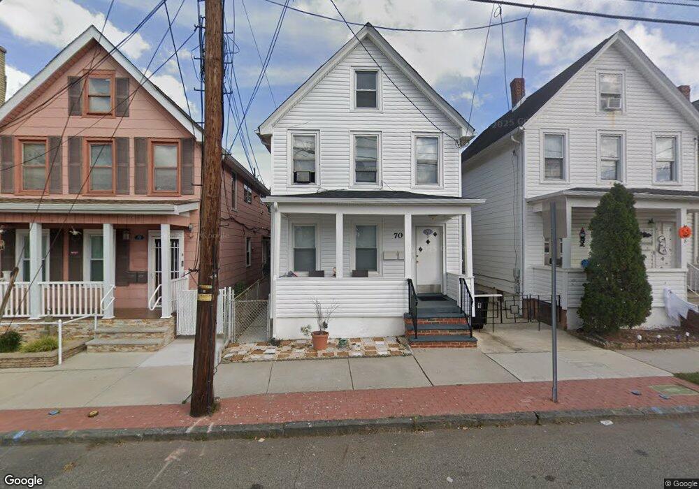
70 Pershing Ave Carteret, NJ 07008
Estimated Value: $485,006 - $562,000
--
Bed
--
Bath
1,764
Sq Ft
$301/Sq Ft
Est. Value
About This Home
This home is located at 70 Pershing Ave, Carteret, NJ 07008 and is currently estimated at $530,752, approximately $300 per square foot. 70 Pershing Ave is a home located in Middlesex County with nearby schools including Carteret High School and St Joseph School.
Ownership History
Date
Name
Owned For
Owner Type
Purchase Details
Closed on
Nov 26, 2012
Sold by
Singh Randip
Bought by
Kaur Kamaljeet
Current Estimated Value
Purchase Details
Closed on
May 10, 2002
Sold by
Santiago Manuel
Bought by
Kaur Karnaljet and Singh Randid
Home Financials for this Owner
Home Financials are based on the most recent Mortgage that was taken out on this home.
Original Mortgage
$138,000
Interest Rate
6.92%
Create a Home Valuation Report for This Property
The Home Valuation Report is an in-depth analysis detailing your home's value as well as a comparison with similar homes in the area
Home Values in the Area
Average Home Value in this Area
Purchase History
| Date | Buyer | Sale Price | Title Company |
|---|---|---|---|
| Kaur Kamaljeet | -- | None Available | |
| Kaur Karnaljet | $205,000 | -- |
Source: Public Records
Mortgage History
| Date | Status | Borrower | Loan Amount |
|---|---|---|---|
| Previous Owner | Kaur Karnaljet | $138,000 |
Source: Public Records
Tax History Compared to Growth
Tax History
| Year | Tax Paid | Tax Assessment Tax Assessment Total Assessment is a certain percentage of the fair market value that is determined by local assessors to be the total taxable value of land and additions on the property. | Land | Improvement |
|---|---|---|---|---|
| 2025 | $6,427 | $503,400 | $250,000 | $253,400 |
| 2024 | $6,262 | $201,600 | $72,000 | $129,600 |
| 2023 | $6,262 | $201,600 | $72,000 | $129,600 |
| 2022 | $6,088 | $201,600 | $72,000 | $129,600 |
| 2021 | $5,631 | $201,600 | $72,000 | $129,600 |
| 2020 | $5,798 | $201,600 | $72,000 | $129,600 |
| 2019 | $5,631 | $201,600 | $72,000 | $129,600 |
| 2018 | $5,498 | $201,600 | $72,000 | $129,600 |
| 2017 | $5,302 | $201,600 | $72,000 | $129,600 |
| 2016 | $5,830 | $184,100 | $67,000 | $117,100 |
| 2015 | $5,746 | $184,100 | $67,000 | $117,100 |
| 2014 | $5,495 | $184,100 | $67,000 | $117,100 |
Source: Public Records
Map
Nearby Homes
- 42 Pulaski Ave
- 82 Pulaski Ave
- 14 Linden St
- 12 Hudson St
- 4 Somerset St
- 68 Atlantic St
- 36 E Laurel St
- 160 Pershing Ave
- 88 Lowell St
- 12 Edwin St
- 54 Bergen St
- 3 Jessie St
- 84-86 Washington Ave
- 114 Washington Ave
- 118 Holly St
- 141 Emerson St
- 22 N Whittier St Unit B
- 76 Daniel St
- 81 Hickory St
- 245 Carteret Ave
- 68 Pershing Ave
- 72 Pershing Ave
- 66 Pershing Ave
- 74 Pershing Ave
- 64 Pershing Ave
- 64 Pershing Ave Unit 1
- 62 Larch St
- 33 Terminal Ave
- 60 Larch St Unit 62
- 65 Pershing Ave
- 63 Pershing Ave
- 58 Larch St
- 69 Pershing Ave
- 69 Pershing Ave Unit 1
- 69 Pershing Ave Unit 2
- 56 Larch St
- 43 Terminal Ave
- 63 Larch St
- 61 Larch St
- 54 Larch St Unit 3