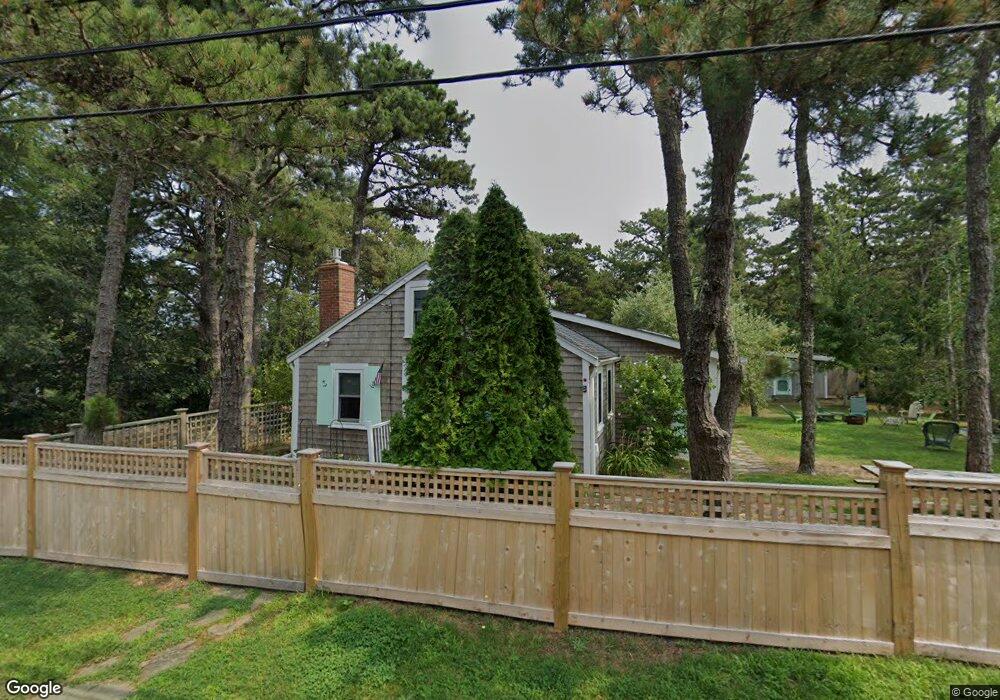
70 Summit St Wellfleet, MA 02667
Estimated Value: $783,779 - $1,177,000
4
Beds
2
Baths
1,200
Sq Ft
$769/Sq Ft
Est. Value
About This Home
This home is located at 70 Summit St, Wellfleet, MA 02667 and is currently estimated at $922,695, approximately $768 per square foot. 70 Summit St is a home located in Barnstable County with nearby schools including Wellfleet Elementary School, Nauset Regional Middle School, and Nauset Regional High School.
Ownership History
Date
Name
Owned For
Owner Type
Purchase Details
Closed on
Jan 26, 2010
Sold by
Cutter Darryl S
Bought by
Reynolds-Cohen Katherine
Current Estimated Value
Home Financials for this Owner
Home Financials are based on the most recent Mortgage that was taken out on this home.
Original Mortgage
$384,000
Outstanding Balance
$249,049
Interest Rate
4.79%
Mortgage Type
Purchase Money Mortgage
Estimated Equity
$673,646
Purchase Details
Closed on
Jul 9, 2004
Sold by
Cutter Carolyn D and Cutter Robert S
Bought by
Cutter Darryl S
Home Financials for this Owner
Home Financials are based on the most recent Mortgage that was taken out on this home.
Original Mortgage
$240,000
Interest Rate
6.32%
Mortgage Type
Purchase Money Mortgage
Create a Home Valuation Report for This Property
The Home Valuation Report is an in-depth analysis detailing your home's value as well as a comparison with similar homes in the area
Home Values in the Area
Average Home Value in this Area
Purchase History
| Date | Buyer | Sale Price | Title Company |
|---|---|---|---|
| Reynolds-Cohen Katherine | $480,000 | -- | |
| Reynolds-Cohen Katherine | $480,000 | -- | |
| Cutter Darryl S | $300,000 | -- | |
| Cutter Darryl S | $300,000 | -- |
Source: Public Records
Mortgage History
| Date | Status | Borrower | Loan Amount |
|---|---|---|---|
| Open | Reynolds-Cohen Katherine | $384,000 | |
| Closed | Cutter Darryl S | $384,000 | |
| Previous Owner | Cutter Darryl S | $240,000 |
Source: Public Records
Tax History
| Year | Tax Paid | Tax Assessment Tax Assessment Total Assessment is a certain percentage of the fair market value that is determined by local assessors to be the total taxable value of land and additions on the property. | Land | Improvement |
|---|---|---|---|---|
| 2025 | $4,931 | $693,500 | $387,400 | $306,100 |
| 2024 | $4,552 | $666,500 | $369,000 | $297,500 |
| 2023 | $3,974 | $571,000 | $312,700 | $258,300 |
| 2022 | $3,589 | $461,300 | $274,300 | $187,000 |
| 2021 | $4,978 | $372,600 | $244,900 | $127,700 |
| 2020 | $2,904 | $374,700 | $247,900 | $126,800 |
| 2019 | $2,866 | $370,800 | $247,900 | $122,900 |
| 2018 | $3,978 | $370,000 | $247,900 | $122,100 |
| 2017 | $2,503 | $369,200 | $247,900 | $121,300 |
| 2016 | $2,164 | $316,800 | $196,300 | $120,500 |
| 2015 | $2,130 | $314,100 | $194,400 | $119,700 |
Source: Public Records
Map
Nearby Homes
- 164 Kendrick Ave Unit C
- 35 Holbrook Ave
- 20 Bank St
- 135 Marven Way
- 30 Harbor View Cir
- 40 Old Long Pond Rd
- 105 Howard Ct
- 320 Coles Neck Rd
- 49 Oak Valley Rd
- 45 Indian Neck Rd
- 240 Gross Hill Rd
- 2032 State Hwy Rte 6 Unit F/ (6)
- 1937 State Highway Route 6 Unit E
- 1937 State Highway Route 6 Unit E
- 175 Delphi Path
- 7 Arrowhead Farm Rd
- 95 Old County Rd
- 80 4th St
- 110 Prince Valley Rd
- 95 Barker St