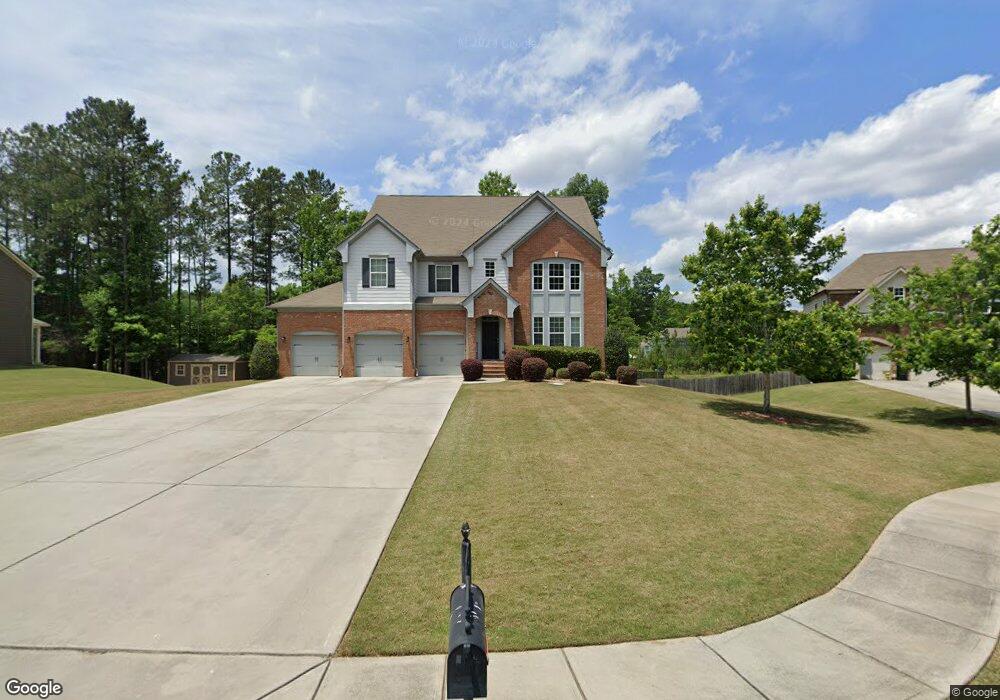
70 Sweetwater Way Senoia, GA 30276
Estimated Value: $546,500 - $624,000
7
Beds
4
Baths
4,054
Sq Ft
$144/Sq Ft
Est. Value
About This Home
This home is located at 70 Sweetwater Way, Senoia, GA 30276 and is currently estimated at $583,375, approximately $143 per square foot. 70 Sweetwater Way is a home located in Coweta County with nearby schools including Willis Road Elementary School, East Coweta Middle School, and East Coweta High School.
Ownership History
Date
Name
Owned For
Owner Type
Purchase Details
Closed on
May 12, 2011
Sold by
Dr Horton Inc
Bought by
Sany America Inc
Current Estimated Value
Purchase Details
Closed on
Mar 8, 2005
Sold by
Scarbrough and Rolader Developme
Bought by
D R Horton Homes Inc
Purchase Details
Closed on
Aug 19, 2004
Sold by
Tlsr Lp
Bought by
428 Llc
Purchase Details
Closed on
Mar 10, 2004
Sold by
Twin Lakes Partnersh
Bought by
Twin Lakes Investors Llc
Purchase Details
Closed on
Sep 8, 1989
Bought by
Twin Lakes Partnersh
Purchase Details
Closed on
Jun 30, 1988
Bought by
Atlanta Associates I
Create a Home Valuation Report for This Property
The Home Valuation Report is an in-depth analysis detailing your home's value as well as a comparison with similar homes in the area
Home Values in the Area
Average Home Value in this Area
Purchase History
| Date | Buyer | Sale Price | Title Company |
|---|---|---|---|
| Sany America Inc | $255,000 | -- | |
| D R Horton Homes Inc | $7,640,000 | -- | |
| 428 Llc | -- | -- | |
| Twin Lakes Investors Llc | $5,250,000 | -- | |
| Twin Lakes Partnersh | -- | -- | |
| Atlanta Associates I | -- | -- |
Source: Public Records
Tax History Compared to Growth
Tax History
| Year | Tax Paid | Tax Assessment Tax Assessment Total Assessment is a certain percentage of the fair market value that is determined by local assessors to be the total taxable value of land and additions on the property. | Land | Improvement |
|---|---|---|---|---|
| 2024 | $5,700 | $205,036 | $30,000 | $175,036 |
| 2023 | $5,700 | $183,620 | $30,000 | $153,620 |
| 2022 | $4,496 | $153,872 | $24,000 | $129,872 |
| 2021 | $4,914 | $155,098 | $24,000 | $131,098 |
| 2020 | $5,006 | $155,098 | $24,000 | $131,098 |
| 2019 | $4,756 | $133,127 | $26,000 | $107,127 |
| 2018 | $4,781 | $133,127 | $26,000 | $107,127 |
| 2017 | $4,633 | $128,386 | $26,000 | $102,386 |
| 2016 | $4,935 | $136,919 | $26,000 | $110,919 |
| 2015 | $4,362 | $122,919 | $12,000 | $110,919 |
| 2014 | $4,186 | $121,023 | $12,000 | $109,023 |
Source: Public Records
Map
Nearby Homes
- 135 Mulberry Dr
- 35 Paddle Boat Cove
- 250 Calebee Ave
- 165 Tudor Way
- 400 Mulberry Dr
- 225 Renwick Dr
- 110 Cohabie Ct
- 305 Staffin Dr
- 270 Staffin Dr
- 260 Staffin Dr
- SAVANNAH Plan at Heritage Pointe
- Jean Lee Plan at Heritage Pointe
- Hampshire Plan at Heritage Pointe
- Edison Plan at Heritage Pointe
- Marlene Plan at Heritage Pointe
- 330 Renwick Dr
- 155 Filson Dr
- 160 Blue Heron Blvd
- 70 Teal Ct
- 181 Brittany Ln
- 60 Sweetwater Way
- 80 Sweetwater Way
- 50 Sweetwater Way
- 65 Sweetwater Way
- 215 Mulberry Dr Unit 36
- 215 Mulberry Dr
- 40 Sweetwater Way
- 225 Mulberry Dr Unit 37
- 225 Mulberry Dr
- 205 Mulberry Dr
- 205 Mulberry Dr Unit 35
- 75 Sweetwater Way
- 45 Sweetwater Way
- 235 Mulberry Dr Unit 38
- 235 Mulberry Dr
- 0 Sweetwater Way Unit 7214703
- 195 Mulberry Dr Unit 34
- 195 Mulberry Dr
- 245 Mulberry Dr
- 179 Mulberry Dr