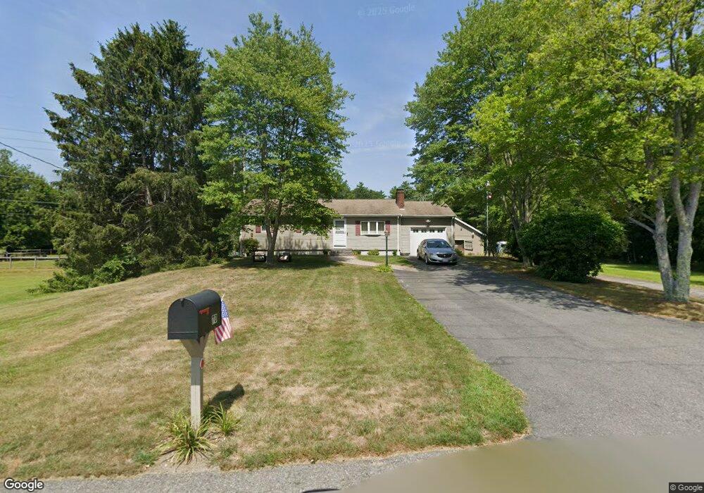
70 Warren St W Raynham, MA 02767
Estimated Value: $548,000 - $632,000
3
Beds
2
Baths
1,824
Sq Ft
$323/Sq Ft
Est. Value
About This Home
This home is located at 70 Warren St W, Raynham, MA 02767 and is currently estimated at $589,150, approximately $322 per square foot. 70 Warren St W is a home located in Bristol County with nearby schools including Merrill Elementary School, LaLiberte Elementary School, and Williams Intermediate School.
Ownership History
Date
Name
Owned For
Owner Type
Purchase Details
Closed on
Nov 30, 1995
Sold by
Butler Norman J and Butler Evelyn E
Bought by
Heffernan Philip J and Butler Kerri A
Current Estimated Value
Home Financials for this Owner
Home Financials are based on the most recent Mortgage that was taken out on this home.
Original Mortgage
$100,000
Interest Rate
7.37%
Mortgage Type
Purchase Money Mortgage
Create a Home Valuation Report for This Property
The Home Valuation Report is an in-depth analysis detailing your home's value as well as a comparison with similar homes in the area
Home Values in the Area
Average Home Value in this Area
Purchase History
| Date | Buyer | Sale Price | Title Company |
|---|---|---|---|
| Heffernan Philip J | $125,000 | -- |
Source: Public Records
Mortgage History
| Date | Status | Borrower | Loan Amount |
|---|---|---|---|
| Open | Heffernan Philip J | $75,000 | |
| Closed | Heffernan Philip J | $100,000 |
Source: Public Records
Tax History
| Year | Tax Paid | Tax Assessment Tax Assessment Total Assessment is a certain percentage of the fair market value that is determined by local assessors to be the total taxable value of land and additions on the property. | Land | Improvement |
|---|---|---|---|---|
| 2025 | $6,211 | $513,300 | $213,000 | $300,300 |
| 2024 | $6,199 | $499,100 | $213,000 | $286,100 |
| 2023 | $5,822 | $428,100 | $191,100 | $237,000 |
| 2022 | $5,763 | $388,600 | $181,100 | $207,500 |
| 2021 | $5,280 | $359,400 | $171,100 | $188,300 |
| 2020 | $5,026 | $348,800 | $163,100 | $185,700 |
| 2019 | $4,679 | $328,800 | $143,100 | $185,700 |
| 2018 | $4,466 | $299,700 | $137,100 | $162,600 |
| 2017 | $4,196 | $279,200 | $131,100 | $148,100 |
| 2016 | $4,122 | $275,200 | $127,100 | $148,100 |
| 2015 | $3,894 | $255,500 | $125,700 | $129,800 |
Source: Public Records
Map
Nearby Homes
- 75 Warren St W Unit 16
- 152 Forgeriver
- 0 Cape Highway Route 44 Unit 73474847
- 5 Parcels Cape Highway Route 44
- 208 S Main St
- 0 S Main St Unit 73443212
- 28 Barbara Rd
- 136 Dean St
- 136 Dean St Unit A&B
- 26 Nottingham Dr
- 53 Queens Cir
- 33 White St
- 30 Edward Rd
- 21 Sully Rd
- 35 Wilbur St
- 73 Raymond Ave
- 27 Johnson St Unit C
- 27 Johnson St Unit A
- 27 Johnson St Unit B
- 25 Johnson St Unit B
- 84 Warren St W
- 32 Warren St W
- 100 Warren St W
- 23 Warren St W
- 20 Warren St W
- 118 Warren St W
- 75 Warren St W Unit 34
- 75 Warren St W Unit 32
- 75 Warren St W Unit 31
- 75 Warren St W Unit 30
- 75 Warren St W Unit 29
- 75 Warren St W Unit 28
- 75 Warren St W Unit 27
- 75 Warren St W Unit 26
- 75 Warren St W Unit 25
- 75 Warren St W Unit 24
- 75 Warren St W Unit 23
- 75 Warren St W Unit 22
- 75 Warren St W Unit 21
- 75 Warren St W Unit 20
Your Personal Tour Guide
Ask me questions while you tour the home.