
70 Wing Blvd E East Sandwich, MA 02537
Estimated payment $8,775/month
Highlights
- Marina
- Golf Course Community
- Wood Flooring
- Ocean View
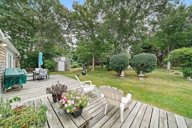
- Deck
- 1 Fireplace
About This Home
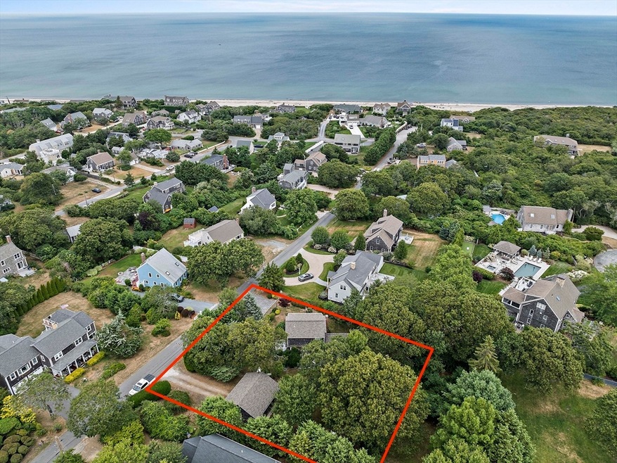
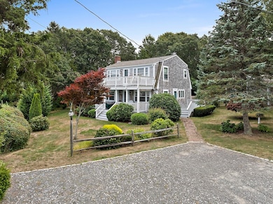
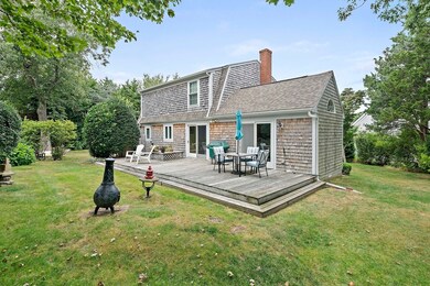
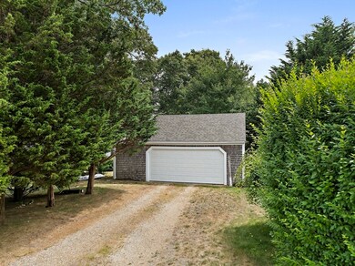
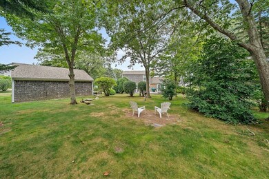
A+ location just 8 houses from the beach, with NO FLOOD INSURANCE! Welcome to Sandwich Downs, a private neighborhood with a quintessential Cape lifestyle in the heart of East Sandwich. Drop your kayak in the water and explore nearby Scorton Creek. Go off-roading at Sandy Neck Beach, and enjoy various local public/private golf courses. Offered for the first time in nearly 30 years, this home sits angled on one of the largest lots in the neighborhood (triple lot), with seasonal water views and tremendous charm. New Roof in 2022. Could easily be reconfigured to 3+ bedrooms, or expanded upon. Front porch, upstairs deck, rear deck, and huge backyard w/ outdoor shower. Oversized detached garage (28' x 24') can fit small/medium sized boats, and could potentially also work as future ADU option. AMPLE PARKING for at least 7 cars! Private Showings by Appointment Only.
Home Details
Home Type
- Single Family
Est. Annual Taxes
- $10,564
Year Built
- Built in 1950
Lot Details
- 0.42 Acre Lot
- Property fronts a private road
- Level Lot
- Cleared Lot
Parking
- 2 Car Detached Garage
- Oversized Parking
- Off-Street Parking
Home Design
- Concrete Perimeter Foundation
Interior Spaces
- 1,536 Sq Ft Home
- 1 Fireplace
- Ocean Views
- Unfinished Basement
- Partial Basement
Kitchen
- Range
- Freezer
- Dishwasher
Flooring
- Wood
- Carpet
Bedrooms and Bathrooms
- 2 Bedrooms
- 2 Full Bathrooms
Laundry
- Dryer
- Washer
Outdoor Features
- Bulkhead
- Deck
Utilities
- Window Unit Cooling System
- 2 Heating Zones
- Heating System Uses Natural Gas
- Baseboard Heating
- 220 Volts
- Private Water Source
- Gas Water Heater
- Private Sewer
Listing and Financial Details
- Assessor Parcel Number M:0055 B:0134,2391790
Community Details
Overview
- No Home Owners Association
- Near Conservation Area
Amenities
- Shops
Recreation
- Marina
- Golf Course Community
- Jogging Path
- Bike Trail
Map
Home Values in the Area
Average Home Value in this Area
Tax History
| Year | Tax Paid | Tax Assessment Tax Assessment Total Assessment is a certain percentage of the fair market value that is determined by local assessors to be the total taxable value of land and additions on the property. | Land | Improvement |
|---|---|---|---|---|
| 2025 | $10,564 | $999,400 | $707,400 | $292,000 |
| 2024 | $10,088 | $934,100 | $628,600 | $305,500 |
| 2023 | $7,510 | $653,000 | $370,100 | $282,900 |
| 2022 | $7,399 | $562,200 | $330,400 | $231,800 |
| 2021 | $7,418 | $538,700 | $331,700 | $207,000 |
| 2020 | $7,380 | $515,700 | $319,400 | $196,300 |
| 2019 | $6,486 | $452,900 | $268,800 | $184,100 |
| 2018 | $6,589 | $461,100 | $289,800 | $171,300 |
| 2017 | $6,509 | $436,000 | $276,300 | $159,700 |
| 2016 | $5,999 | $414,600 | $261,100 | $153,500 |
| 2015 | $6,051 | $408,300 | $257,500 | $150,800 |
Property History
| Date | Event | Price | List to Sale | Price per Sq Ft |
|---|---|---|---|---|
| 08/29/2025 08/29/25 | Pending | -- | -- | -- |
| 08/08/2025 08/08/25 | For Sale | $1,495,000 | -- | $973 / Sq Ft |
Purchase History
| Date | Type | Sale Price | Title Company |
|---|---|---|---|
| Deed | -- | -- |
Mortgage History
| Date | Status | Loan Amount | Loan Type |
|---|---|---|---|
| Open | $847,500 | Reverse Mortgage Home Equity Conversion Mortgage |
Source: MLS Property Information Network (MLS PIN)
MLS Number: 73415618
APN: SAND-000055-000134
Disclaimer: Certain information contained herein is derived from information provided by parties other than Homes.com. All information provided is deemed reliable, but is not guaranteed to be accurate and should be independently verified.
![]() The property listing data and information, or the Images, set forth herein were provided to MLS Property Information Network, Inc. from third party sources, including sellers, lessors and public records, and were compiled by MLS Property Information Network, Inc. The property listing data and information, and the Images, are for the personal, non-commercial use of consumers having a good faith interest in purchasing or leasing listed properties of the type displayed to them and may not be used for any purpose other than to identify prospective properties which such consumers may have a good faith interest in purchasing or leasing. MLS Property Information Network, Inc. and its subscribers disclaim any and all representations and warranties as to the accuracy of the property listing data and information, or as to the accuracy of any of the Images, set forth herein.
The property listing data and information, or the Images, set forth herein were provided to MLS Property Information Network, Inc. from third party sources, including sellers, lessors and public records, and were compiled by MLS Property Information Network, Inc. The property listing data and information, and the Images, are for the personal, non-commercial use of consumers having a good faith interest in purchasing or leasing listed properties of the type displayed to them and may not be used for any purpose other than to identify prospective properties which such consumers may have a good faith interest in purchasing or leasing. MLS Property Information Network, Inc. and its subscribers disclaim any and all representations and warranties as to the accuracy of the property listing data and information, or as to the accuracy of any of the Images, set forth herein.
- 4 Wing Blvd
- 0 Captain Kidd Rd
- 3 Mulberry Cir
- 665 Route 6a
- 507 Massachusetts 6a Unit 9
- 203 N Shore Blvd Unit D
- 203 N Shore Blvd Unit D
- 14 Village Dr
- 6 Harpers Hollow
- 50 Wayside Ln
- 420 Massachusetts 6a
- 46 Chase Rd
- 49 Atkins Rd
- 49 Atkins Rd
- 718 Cedar St
- 36 Atkins Rd Unit D2
- 4 Cowslip Path
- 390 Massachusetts 6a
- 20 Crestview Dr
- 75 Old Toll Rd
