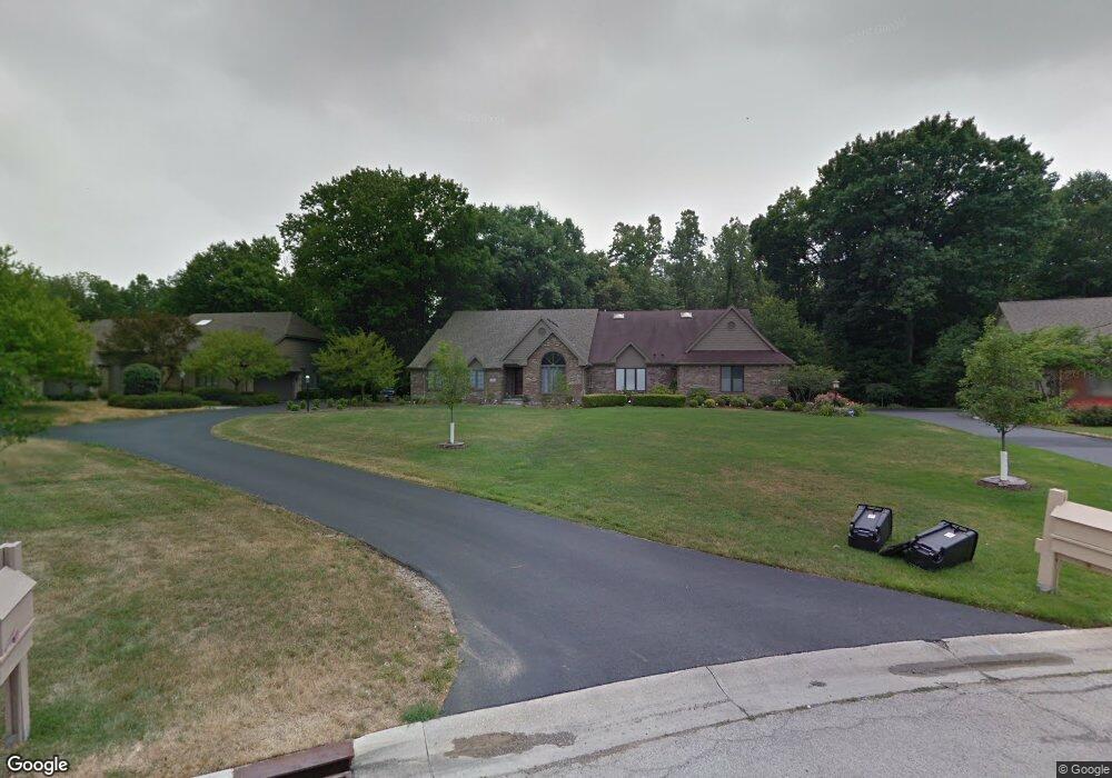
70 Wolfridge Dr Holland, OH 43528
Estimated Value: $340,000 - $363,000
3
Beds
4
Baths
3,800
Sq Ft
$92/Sq Ft
Est. Value
About This Home
This home is located at 70 Wolfridge Dr, Holland, OH 43528 and is currently estimated at $348,107, approximately $91 per square foot. 70 Wolfridge Dr is a home located in Lucas County with nearby schools including Holloway Elementary School, Springfield Middle School, and Springfield High School.
Ownership History
Date
Name
Owned For
Owner Type
Purchase Details
Closed on
Feb 16, 2016
Sold by
Estate Of Stanley R Packard
Bought by
Packard Veronica
Current Estimated Value
Purchase Details
Closed on
Jul 13, 2007
Sold by
Wells Fargo Bank Na
Bought by
Packard Stanley and Packard Veronica
Home Financials for this Owner
Home Financials are based on the most recent Mortgage that was taken out on this home.
Original Mortgage
$134,750
Interest Rate
6.71%
Mortgage Type
Purchase Money Mortgage
Purchase Details
Closed on
Mar 25, 2006
Sold by
Szymanowski Paul M and Szymanowski Suzanne
Bought by
Wells Fargo Bank Na and Registered Holders Of Home Equity Loan A
Purchase Details
Closed on
Aug 28, 1990
Create a Home Valuation Report for This Property
The Home Valuation Report is an in-depth analysis detailing your home's value as well as a comparison with similar homes in the area
Home Values in the Area
Average Home Value in this Area
Purchase History
| Date | Buyer | Sale Price | Title Company |
|---|---|---|---|
| Packard Veronica | -- | None Available | |
| Packard Stanley | $192,500 | Titlequest Agency Inc | |
| Wells Fargo Bank Na | -- | None Available | |
| -- | $30,000 | -- |
Source: Public Records
Mortgage History
| Date | Status | Borrower | Loan Amount |
|---|---|---|---|
| Previous Owner | Packard Stanley | $134,750 |
Source: Public Records
Tax History Compared to Growth
Tax History
| Year | Tax Paid | Tax Assessment Tax Assessment Total Assessment is a certain percentage of the fair market value that is determined by local assessors to be the total taxable value of land and additions on the property. | Land | Improvement |
|---|---|---|---|---|
| 2024 | $2,604 | $96,005 | $10,605 | $85,400 |
| 2023 | $4,864 | $79,590 | $7,875 | $71,715 |
| 2022 | $5,485 | $79,590 | $7,875 | $71,715 |
| 2021 | $5,155 | $79,590 | $7,875 | $71,715 |
| 2020 | $5,030 | $70,455 | $6,685 | $63,770 |
| 2019 | $4,912 | $70,455 | $6,685 | $63,770 |
| 2018 | $5,134 | $70,455 | $6,685 | $63,770 |
| 2017 | $5,390 | $72,205 | $16,800 | $55,405 |
| 2016 | $5,440 | $206,300 | $48,000 | $158,300 |
| 2015 | $5,430 | $206,300 | $48,000 | $158,300 |
| 2014 | $4,259 | $69,440 | $16,170 | $53,270 |
| 2013 | $4,259 | $69,440 | $16,170 | $53,270 |
Source: Public Records
Map
Nearby Homes
- 1705 Henthorne Dr
- 2001 Perrysburg Holland Rd
- 6666 Inglewood Rd
- 2014 Inglewood Rd
- 6363 Millbrook Rd
- 8939 Airport Hwy
- 5844 Swan Creek Dr
- 2258 Tanglewood Dr
- 6856 Morningdew Blvd
- 5721 Bernath Ct Unit GL
- 1562 Saddlebrook Ct Unit B
- 2437 Knights Hill Ln
- 5662 Bernath Ct Unit E
- 5713 Tibaron Ln
- 5615 Baronswood Cir
- 6705 Garden Rd Unit 6705
- 6652 Sue Ln
- 1421 Maumee St
- 6833 Greentree Ln
- 1533 Eaglebrook Rd
- 70 Wolf Ridge Dr
- 68 Wolf Ridge Dr
- 62 Wolf Ridge Dr
- 72 Wolf Ridge Dr
- 66 Wolf Ridge Dr
- 74 Wolf Ridge Dr
- 74 Wolfridge Dr
- 66 Wolfridge Dr
- 64 Wolf Ridge Dr
- 64 Wolfridge Dr
- 71 Wolf Ridge Dr
- 69 Wolf Ridge Dr
- 67 Wolf Ridge Dr
- 60 Wolf Ridge Dr
- 65 Wolf Ridge Dr
- 63 Wolf Ridge Dr
- 56 Wolf Ridge Dr
- 63 Wolfridge Dr
- 54 Wolf Ridge Dr
- 52 Wolf Ridge Dr