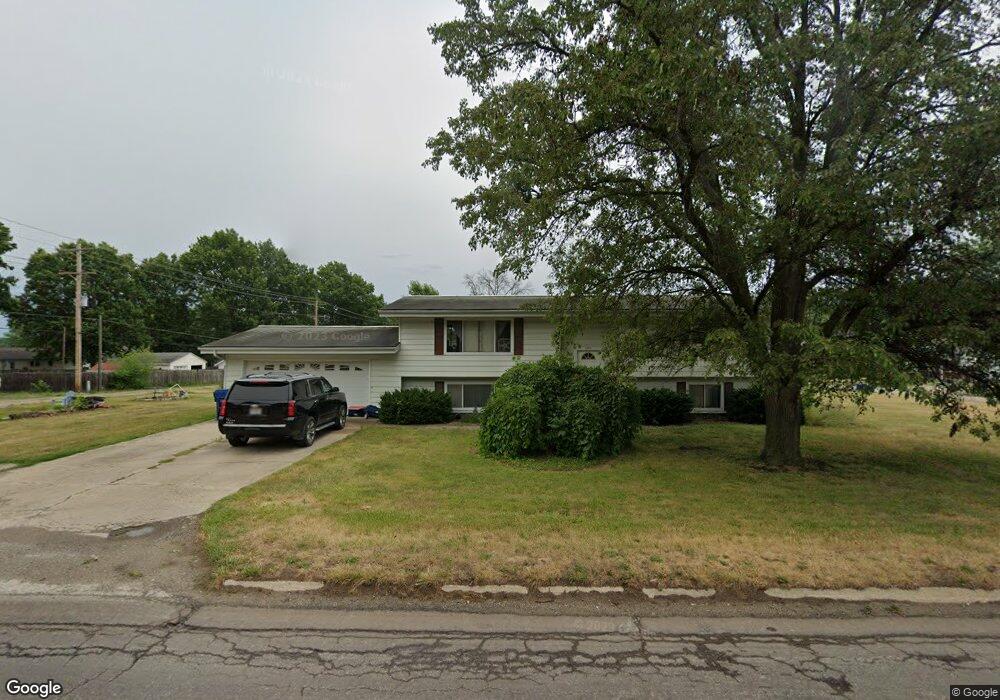
700 N Monroe St Brookfield, MO 64628
Estimated Value: $132,000 - $177,201
3
Beds
1
Bath
1,064
Sq Ft
$145/Sq Ft
Est. Value
About This Home
This home is located at 700 N Monroe St, Brookfield, MO 64628 and is currently estimated at $154,300, approximately $145 per square foot. 700 N Monroe St is a home with nearby schools including Brookfield Elementary School, Brookfield Middle School, and Brookfield High School.
Ownership History
Date
Name
Owned For
Owner Type
Purchase Details
Closed on
Apr 24, 2024
Sold by
Blehm Joyce Trust
Bought by
Boley Randall W and Boley Margaret J
Current Estimated Value
Purchase Details
Closed on
Jan 30, 2024
Sold by
Nelson Frank B
Bought by
Levi Kelly Ents Llc
Home Financials for this Owner
Home Financials are based on the most recent Mortgage that was taken out on this home.
Original Mortgage
$95,000
Interest Rate
5.87%
Mortgage Type
Construction
Purchase Details
Closed on
Jul 8, 2014
Sold by
Evans Erma M
Bought by
Blehm Joyce
Purchase Details
Closed on
Jul 10, 2008
Bought by
Blehm Theador
Create a Home Valuation Report for This Property
The Home Valuation Report is an in-depth analysis detailing your home's value as well as a comparison with similar homes in the area
Home Values in the Area
Average Home Value in this Area
Purchase History
| Date | Buyer | Sale Price | Title Company |
|---|---|---|---|
| Boley Randall W | -- | -- | |
| Levi Kelly Ents Llc | $118,750 | -- | |
| Blehm Joyce | -- | -- | |
| Blehm Theador | -- | -- |
Source: Public Records
Mortgage History
| Date | Status | Borrower | Loan Amount |
|---|---|---|---|
| Previous Owner | Levi Kelly Ents Llc | $95,000 |
Source: Public Records
Tax History
| Year | Tax Paid | Tax Assessment Tax Assessment Total Assessment is a certain percentage of the fair market value that is determined by local assessors to be the total taxable value of land and additions on the property. | Land | Improvement |
|---|---|---|---|---|
| 2025 | -- | $16,785 | $2,679 | $14,106 |
| 2024 | $10 | $16,112 | $2,679 | $13,433 |
| 2023 | $1,005 | $16,112 | $2,679 | $13,433 |
| 2022 | $920 | $14,687 | $2,679 | $12,008 |
| 2021 | $0 | $14,687 | $2,679 | $12,008 |
| 2020 | $922 | $14,687 | $2,679 | $12,008 |
| 2019 | $922 | $14,687 | $2,679 | $12,008 |
| 2018 | $911 | $14,573 | $2,318 | $12,255 |
| 2015 | -- | $14,421 | $2,318 | $12,103 |
| 2011 | -- | $75,800 | $12,200 | $63,600 |
Source: Public Records
Map
Nearby Homes
- 1007 Country Side Dr
- 721 Lincoln St
- 303 Shelby St
- 317 Macon St
- 119 W Dake St
- 1118 Courtland St
- 1002 N State St
- 117 N Main St
- 713 Brookfield Ave
- 420 Smith St
- 420 Mcgowan St
- 417 Laclede Ave
- 627 Mcgowan St
- 304 E Canal St
- 131 Silver Ln
- 547 Harrison St
- 419 Nichols St
- 0 S State St
- 27022 Index Dr
- 683 Wentz St
- 409 E Sedgwick St
- 703 N Monroe St
- 628 N Monroe St
- 722 N Monroe St
- 629 N Monroe St
- 419 E Sedgwick St
- 624 N Monroe St
- 337 E Sedgwick St
- 416 E Sedgwick St
- 416 E Dake St
- 620 N Monroe St
- 420 E Sedgwick St
- 421 E Sedgwick St
- 335 E Sedgwick St
- 418 E Dake St
- 619 N Monroe St
- 723 N Monroe St
- 420 E Dake St
- 618 N Monroe St
- 424 E Sedgwick St
Your Personal Tour Guide
Ask me questions while you tour the home.