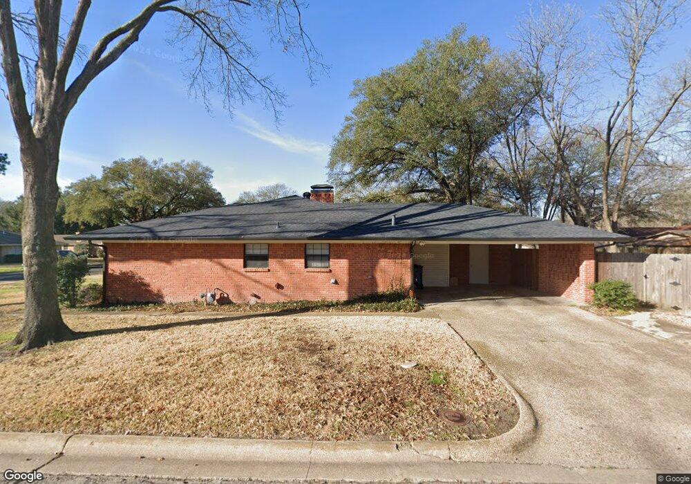
700 Stanford St Corsicana, TX 75110
Estimated Value: $243,697 - $272,000
3
Beds
1
Bath
1,888
Sq Ft
$138/Sq Ft
Est. Value
About This Home
This home is located at 700 Stanford St, Corsicana, TX 75110 and is currently estimated at $260,924, approximately $138 per square foot. 700 Stanford St is a home located in Navarro County with nearby schools including Corsicana High School and William Tyndale Christian Academy.
Ownership History
Date
Name
Owned For
Owner Type
Purchase Details
Closed on
Apr 8, 2022
Sold by
Michael Venable James
Bought by
Lang David A
Current Estimated Value
Purchase Details
Closed on
Oct 17, 2014
Sold by
Montfort Robert C and Montfort Jima
Bought by
Cote Matthew J and Cote Hannah R
Home Financials for this Owner
Home Financials are based on the most recent Mortgage that was taken out on this home.
Original Mortgage
$144,377
Interest Rate
4.12%
Create a Home Valuation Report for This Property
The Home Valuation Report is an in-depth analysis detailing your home's value as well as a comparison with similar homes in the area
Home Values in the Area
Average Home Value in this Area
Purchase History
| Date | Buyer | Sale Price | Title Company |
|---|---|---|---|
| Lang David A | -- | Lowell O Dunn Pc | |
| Cote Matthew J | -- | None Available |
Source: Public Records
Mortgage History
| Date | Status | Borrower | Loan Amount |
|---|---|---|---|
| Previous Owner | Cote Matthew J | $144,377 |
Source: Public Records
Tax History Compared to Growth
Tax History
| Year | Tax Paid | Tax Assessment Tax Assessment Total Assessment is a certain percentage of the fair market value that is determined by local assessors to be the total taxable value of land and additions on the property. | Land | Improvement |
|---|---|---|---|---|
| 2025 | $4,891 | $258,320 | $39,360 | $218,960 |
| 2024 | $5,089 | $268,760 | $36,330 | $232,430 |
| 2023 | $4,397 | $267,870 | $36,330 | $231,540 |
| 2022 | $4,328 | $196,860 | $15,140 | $181,720 |
| 2021 | $4,418 | $169,940 | $15,140 | $154,800 |
| 2020 | $4,470 | $168,440 | $15,140 | $153,300 |
| 2019 | $4,502 | $164,160 | $15,140 | $149,020 |
| 2018 | $4,093 | $149,030 | $12,110 | $136,920 |
| 2017 | $4,090 | $149,120 | $12,110 | $137,010 |
| 2016 | $3,881 | $141,490 | $12,110 | $129,380 |
| 2015 | -- | $145,890 | $12,110 | $133,780 |
| 2014 | -- | $116,450 | $12,110 | $104,340 |
Source: Public Records
Map
Nearby Homes
- 800 Imperial Ln
- TBD Lot 56 Northwest Ave
- 1235 Lexington Square
- 1906 Mimosa Dr
- 2110 Dartmouth Ln
- 1724 N Beaton St
- TBD N Beaton St
- 1605 N Beaton St
- 110 Woodland Ave
- 115 Woodland Ave
- 2200 N Beaton St
- 118 Woodland Ave
- 111 E Rob Ave
- 120 Woodland Ave
- 1424 Bowie Dr
- 906 N Commerce St
- 1000 Bryn Mawr St
- 2629 Fish Tank Rd
- 901 N Commerce St
- 1004 Bryn Mawr St
- 701 Stanford St
- 704 Stanford St
- 610 Stanford St
- 705 Stanford St
- 611 Stanford St
- 608 Stanford St
- 705 Oxford St
- 611 Oxford St
- 708 Stanford St
- 701 Oxford St
- 709 Stanford St
- 609 Stanford St
- 609 Oxford St
- 709 Oxford Ave
- 709 Oxford St
- 700 Lexington Dr
- 606 Stanford St
- 702 Lexington Dr
- 713 Stanford St
- 606 Lexington Dr