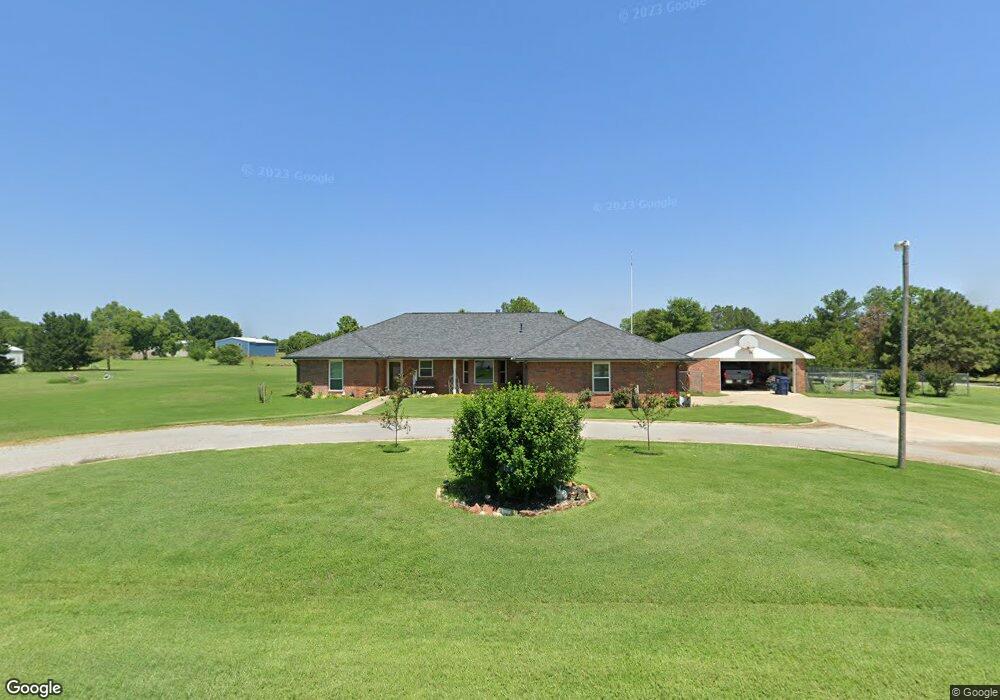
7004 Red Robin Rd Duncan, OK 73533
Estimated Value: $246,000 - $293,000
3
Beds
2
Baths
2,020
Sq Ft
$134/Sq Ft
Est. Value
About This Home
This home is located at 7004 Red Robin Rd, Duncan, OK 73533 and is currently estimated at $270,726, approximately $134 per square foot. 7004 Red Robin Rd is a home located in Stephens County with nearby schools including Marlow Elementary School, Marlow Middle School, and Marlow High School.
Ownership History
Date
Name
Owned For
Owner Type
Purchase Details
Closed on
Dec 28, 2011
Sold by
Lynch David L
Bought by
Lynch Victria N
Current Estimated Value
Purchase Details
Closed on
Jun 10, 1996
Sold by
Hertzler Leon F
Purchase Details
Closed on
Jun 15, 1990
Create a Home Valuation Report for This Property
The Home Valuation Report is an in-depth analysis detailing your home's value as well as a comparison with similar homes in the area
Purchase History
| Date | Buyer | Sale Price | Title Company |
|---|---|---|---|
| Lynch Victria N | -- | None Available | |
| -- | $117,000 | -- | |
| -- | $3,500 | -- |
Source: Public Records
Tax History
| Year | Tax Paid | Tax Assessment Tax Assessment Total Assessment is a certain percentage of the fair market value that is determined by local assessors to be the total taxable value of land and additions on the property. | Land | Improvement |
|---|---|---|---|---|
| 2025 | $2,030 | $21,187 | $2,098 | $19,089 |
| 2024 | $1,940 | $19,970 | $2,097 | $17,873 |
| 2023 | $1,940 | $19,971 | $2,098 | $17,873 |
| 2022 | $1,827 | $19,388 | $2,097 | $17,291 |
| 2021 | $1,559 | $18,277 | $2,097 | $16,180 |
| 2020 | $1,565 | $17,743 | $2,097 | $15,646 |
| 2019 | $1,508 | $17,227 | $2,097 | $15,130 |
| 2018 | $1,450 | $17,227 | $2,097 | $15,130 |
| 2017 | $1,404 | $16,725 | $2,097 | $14,628 |
| 2016 | $1,359 | $15,765 | $2,097 | $13,668 |
| 2015 | $951 | $15,306 | $2,097 | $13,209 |
| 2014 | $951 | $14,860 | $2,097 | $12,763 |
Source: Public Records
Map
Nearby Homes
- 0 N 44th St
- 1793 W Gatlin Rd
- 6161 N Alaska Dr
- 280251 Tanglewood Dr
- 6191 N Alaska Dr
- 279389 Highway 7
- 161754 N Hwy 81
- ??? N Highway 81
- E Gatlin Rd Unit Marlow OK 73055
- 278824 E 1690 Rd
- 2001 Kingsbury Rd
- 5066 Whispering Hills Dr
- 3606 Woodknoll
- 3602 Woodknoll
- 0 Clear Springs Dr
- 3005 Springdale Ln
- 1308 Twisted Oaks Dr
- 2102 Stoneridge Ln
- 805 Daryl Place
- 1105 Twilight Beach Rd
- 7105 Red Robin Rd
- 7010 Red Robin Rd
- 3120 Scissortail Dr
- 280725 Whippoorwill Ln
- 7015 Red Robin Rd
- 3120 Whipporwill Ln
- 3125 Whipporwill Ln
- 3110 Scissortail Dr
- 168177 Red Robin Rd
- 3110 Whipporwill Ln
- 3025 Whipporwill Ln
- 280742 280742 Scissortail
- 3125 Scissortail Dr
- 3020 Whipporwill Ln
- 280875 Scissortail Dr
- 280826 Scissortail Dr
- 168151 Red Robin Rd
- 168151 Red Robin Rd
- 168151 168151 Red Robin Rd
- 3015 Whipporwill Ln
Your Personal Tour Guide
Ask me questions while you tour the home.