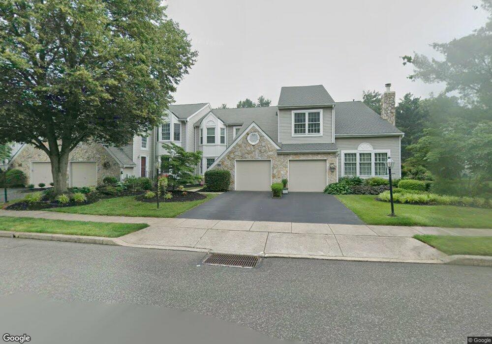
7005 Birdie Ln Doylestown, PA 18901
Estimated Value: $504,836 - $527,000
3
Beds
3
Baths
2,158
Sq Ft
$240/Sq Ft
Est. Value
About This Home
This home is located at 7005 Birdie Ln, Doylestown, PA 18901 and is currently estimated at $518,209, approximately $240 per square foot. 7005 Birdie Ln is a home located in Bucks County with nearby schools including Bridge Valley Elementary School, Lenape Middle School, and Central Bucks High School-West.
Ownership History
Date
Name
Owned For
Owner Type
Purchase Details
Closed on
Jul 30, 1997
Sold by
Wirth Carole A
Bought by
Hughes Christopher
Current Estimated Value
Home Financials for this Owner
Home Financials are based on the most recent Mortgage that was taken out on this home.
Original Mortgage
$97,000
Outstanding Balance
$14,565
Interest Rate
7.56%
Estimated Equity
$503,644
Purchase Details
Closed on
Feb 6, 1996
Sold by
Wirth George F and Wirth Carole A
Bought by
Wirth Carole A
Create a Home Valuation Report for This Property
The Home Valuation Report is an in-depth analysis detailing your home's value as well as a comparison with similar homes in the area
Home Values in the Area
Average Home Value in this Area
Purchase History
| Date | Buyer | Sale Price | Title Company |
|---|---|---|---|
| Hughes Christopher | $164,900 | -- | |
| Wirth Carole A | -- | -- |
Source: Public Records
Mortgage History
| Date | Status | Borrower | Loan Amount |
|---|---|---|---|
| Open | Hughes Christopher | $97,000 |
Source: Public Records
Tax History Compared to Growth
Tax History
| Year | Tax Paid | Tax Assessment Tax Assessment Total Assessment is a certain percentage of the fair market value that is determined by local assessors to be the total taxable value of land and additions on the property. | Land | Improvement |
|---|---|---|---|---|
| 2025 | $5,472 | $30,920 | $3,200 | $27,720 |
| 2024 | $5,472 | $30,920 | $3,200 | $27,720 |
| 2023 | $5,217 | $30,920 | $3,200 | $27,720 |
| 2022 | $5,159 | $30,920 | $3,200 | $27,720 |
| 2021 | $5,053 | $30,920 | $3,200 | $27,720 |
| 2020 | $5,030 | $30,920 | $3,200 | $27,720 |
| 2019 | $4,976 | $30,920 | $3,200 | $27,720 |
| 2018 | $4,960 | $30,920 | $3,200 | $27,720 |
| 2017 | $4,922 | $30,920 | $3,200 | $27,720 |
| 2016 | $4,891 | $30,920 | $3,200 | $27,720 |
| 2015 | -- | $30,920 | $3,200 | $27,720 |
| 2014 | -- | $30,920 | $3,200 | $27,720 |
Source: Public Records
Map
Nearby Homes
- 125 Edison Furlong Rd
- 45 Bedford Ave
- 60 Quarry Rd
- 1249 Pebble Hill Rd
- 2226 Orchard Hill Cir
- 1997 Brook Ln
- 200 Beech Blvd Unit 301
- 1323 School Ln
- 137 Pebble Woods Dri Pebble Woods Dr
- 2227 Sand Trap Rd
- 82 Avalon Ct Unit 2005
- 612 Bethel Ln Unit THE ROOSEVELT PLAN
- 1403 E Fernbrook Dr
- 547 Mccarty Dr
- 2443 Sugar Bottom Rd
- 21 Shady Springs Dr
- 108 Eagle Ct Unit 105
- 2127 York Rd
- 3060 Cloverly Dr
- 1417 Bentley Dr