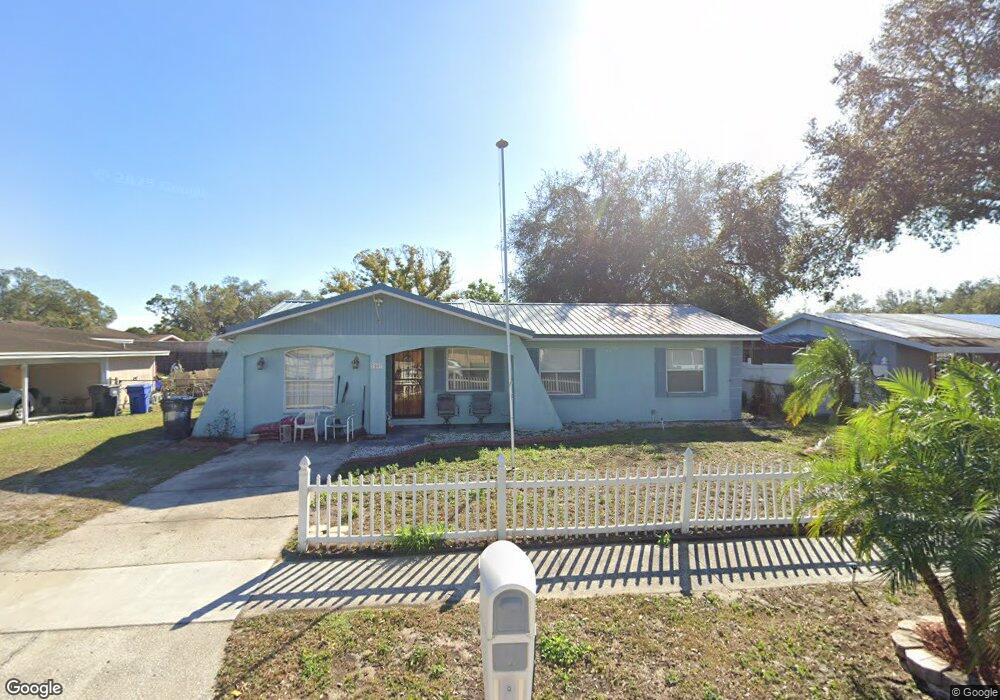
7007 Flint Dr Tampa, FL 33619
Great Palm River Point NeighborhoodEstimated Value: $296,000 - $326,000
3
Beds
1
Bath
1,401
Sq Ft
$223/Sq Ft
Est. Value
About This Home
This home is located at 7007 Flint Dr, Tampa, FL 33619 and is currently estimated at $312,086, approximately $222 per square foot. 7007 Flint Dr is a home located in Hillsborough County with nearby schools including Bing Elementary School, Giunta Middle School, and Spoto High School.
Ownership History
Date
Name
Owned For
Owner Type
Purchase Details
Closed on
Mar 17, 2023
Sold by
Barber Thomas H
Bought by
Barber Thomas H and Dees Mary Lynn
Current Estimated Value
Purchase Details
Closed on
May 20, 2002
Sold by
Garcia Nick J
Bought by
Reed Robert
Home Financials for this Owner
Home Financials are based on the most recent Mortgage that was taken out on this home.
Original Mortgage
$50,000
Interest Rate
7.12%
Purchase Details
Closed on
Mar 19, 2002
Sold by
Ephens Eugene Coc St C
Bought by
Garcia Nick J
Create a Home Valuation Report for This Property
The Home Valuation Report is an in-depth analysis detailing your home's value as well as a comparison with similar homes in the area
Home Values in the Area
Average Home Value in this Area
Purchase History
| Date | Buyer | Sale Price | Title Company |
|---|---|---|---|
| Barber Thomas H | -- | -- | |
| Reed Robert | $58,000 | -- | |
| Garcia Nick J | -- | -- |
Source: Public Records
Mortgage History
| Date | Status | Borrower | Loan Amount |
|---|---|---|---|
| Previous Owner | Garcia Nick J | $50,000 |
Source: Public Records
Tax History Compared to Growth
Tax History
| Year | Tax Paid | Tax Assessment Tax Assessment Total Assessment is a certain percentage of the fair market value that is determined by local assessors to be the total taxable value of land and additions on the property. | Land | Improvement |
|---|---|---|---|---|
| 2024 | $1,057 | $56,689 | -- | -- |
| 2023 | $1,025 | $55,038 | $0 | $0 |
| 2022 | $926 | $53,435 | $0 | $0 |
| 2021 | $912 | $51,879 | $0 | $0 |
| 2020 | $849 | $50,597 | $0 | $0 |
| 2019 | $785 | $49,459 | $0 | $0 |
| 2018 | $737 | $48,537 | $0 | $0 |
| 2017 | $717 | $77,680 | $0 | $0 |
| 2016 | $660 | $45,076 | $0 | $0 |
| 2015 | $661 | $44,763 | $0 | $0 |
| 2014 | $638 | $44,408 | $0 | $0 |
| 2013 | -- | $43,752 | $0 | $0 |
Source: Public Records
Map
Nearby Homes
- 2067 Balfour Cir
- 2406 S 68th St
- 7102 Reindeer Rd
- 1716 Lancelot Loop
- 6605 24th Ave S
- 2416 S 67th St
- 7620 Dennison Dr
- 7112 Robindale Rd
- 1506 S 78th St
- 2027 Warrington Way
- 1721 Darlington Dr
- 7420 Aripeka Dr
- 7620 32nd Ave S
- 2030 Windsor Way
- 6003 16th Ave S
- 1009 S 70th St
- 1215 Maydell Dr
- 2008 S 58th St
- 8528 Gold Ridge Cir
- 3508 S 75th St
- 7005 Flint Dr
- 7009 Flint Dr Unit 5
- 2077 Balfour Cir
- 2079 Balfour Cir
- 2075 Balfour Cir
- 7003 Flint Dr
- 7011 Flint Dr
- 7008 Flint Dr
- 2081 Balfour Cir
- 7006 Flint Dr
- 7010 Flint Dr
- 2073 Balfour Cir
- 7013 Flint Dr
- 7001 Flint Dr
- 7004 Flint Dr
- 7012 Flint Dr Unit 5
- 2071 Balfour Cir
- 2083 Balfour Cir
- 7014 Flint Dr
- 7002 Flint Dr