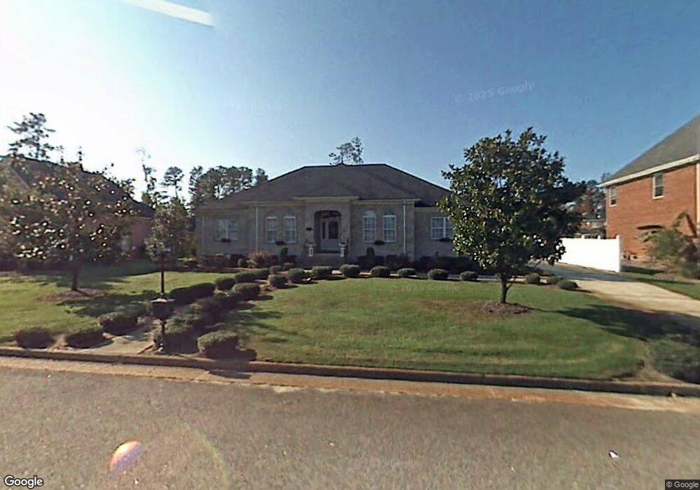
7008 Neal Ct Suffolk, VA 23434
Chuckatuck NeighborhoodEstimated Value: $531,785 - $659,000
4
Beds
3
Baths
2,749
Sq Ft
$217/Sq Ft
Est. Value
About This Home
This home is located at 7008 Neal Ct, Suffolk, VA 23434 and is currently estimated at $597,696, approximately $217 per square foot. 7008 Neal Ct is a home located in Suffolk City with nearby schools including Oakland Elementary School, King's Fork Middle School, and King's Fork High School.
Ownership History
Date
Name
Owned For
Owner Type
Purchase Details
Closed on
Nov 29, 2018
Sold by
Morgan Delores
Bought by
Anderson Mark A and Anderson Becky B
Current Estimated Value
Home Financials for this Owner
Home Financials are based on the most recent Mortgage that was taken out on this home.
Original Mortgage
$114,700
Outstanding Balance
$101,053
Interest Rate
4.8%
Mortgage Type
New Conventional
Estimated Equity
$496,643
Create a Home Valuation Report for This Property
The Home Valuation Report is an in-depth analysis detailing your home's value as well as a comparison with similar homes in the area
Home Values in the Area
Average Home Value in this Area
Purchase History
| Date | Buyer | Sale Price | Title Company |
|---|---|---|---|
| Anderson Mark A | $34,400 | Attorney |
Source: Public Records
Mortgage History
| Date | Status | Borrower | Loan Amount |
|---|---|---|---|
| Open | Anderson Mark A | $114,700 |
Source: Public Records
Tax History Compared to Growth
Tax History
| Year | Tax Paid | Tax Assessment Tax Assessment Total Assessment is a certain percentage of the fair market value that is determined by local assessors to be the total taxable value of land and additions on the property. | Land | Improvement |
|---|---|---|---|---|
| 2024 | $5,648 | $478,800 | $118,300 | $360,500 |
| 2023 | $5,516 | $463,300 | $118,300 | $345,000 |
| 2022 | $4,480 | $411,000 | $118,300 | $292,700 |
| 2021 | $4,125 | $371,600 | $78,900 | $292,700 |
| 2020 | $3,984 | $358,900 | $78,900 | $280,000 |
| 2019 | $3,984 | $358,900 | $78,900 | $280,000 |
| 2018 | $3,758 | $338,800 | $78,900 | $259,900 |
| 2017 | $3,625 | $338,800 | $78,900 | $259,900 |
| 2016 | $3,625 | $338,800 | $78,900 | $259,900 |
| 2015 | $1,925 | $325,800 | $78,900 | $246,900 |
| 2014 | $1,925 | $325,800 | $78,900 | $246,900 |
Source: Public Records
Map
Nearby Homes
- The Rembert Plan at River Highlands
- The Alden Plan at River Highlands
- The Tremont Plan at River Highlands
- The Highland Plan at River Highlands
- 124 Getty Rd
- 122 Getty Rd
- 102 Getty Rd
- 156 Getty Rd
- 187 Peck Ln
- Edison Plan at River Highlands - Smart Living
- Curie Plan at River Highlands - Smart Living
- Quinn Plan at River Highlands - Smart Living
- Maxwell Plan at River Highlands - Smart Living
- King Plan at River Highlands - Smart Living
- Hawking Plan at River Highlands - Smart Living
- Newton Plan at River Highlands - Smart Living
- Elgin Plan at River Highlands - The Terry Peterson Companies
- Dunnet Plan at River Highlands - The Terry Peterson Companies
- Castlebay Plan at River Highlands - The Terry Peterson Companies
- Banavie I Plan at River Highlands - The Terry Peterson Companies
- 7010 Neal Ct
- 7006 Neal Ct
- 6003 Ram Ct
- 5039 Riverfront Dr
- 5037 Riverfront Dr
- 7007 Neal Ct
- 7009 Neal Ct
- 7012 Neal Ct
- 6004 Ram Ct
- 7005 Neal Ct
- 5035 Riverfront Dr
- 5041 Riverfront Dr
- LOT 45 Riverfront Dr
- LOT 38 Riverfront Dr
- 7011 Neal Ct
- 7003 Neal Ct
- 6002 Ram Ct
- 5043 Riverfront Dr
- 164 Sack Point Rd
- 168 Sack Point Rd