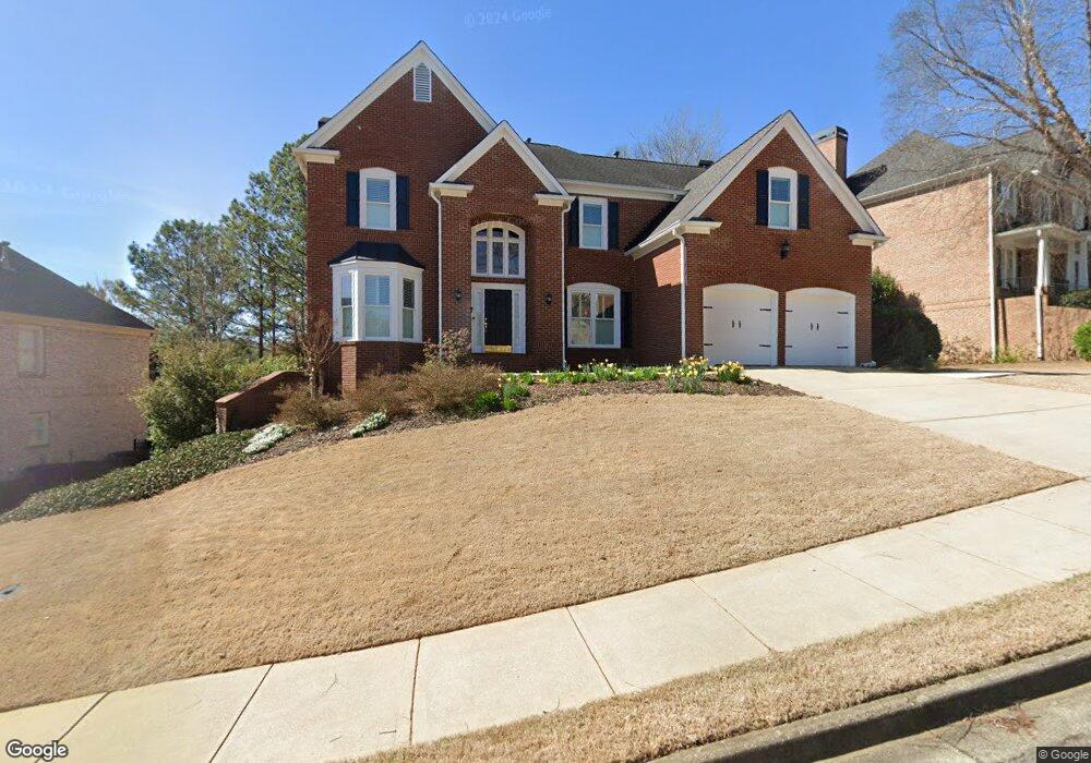
7009 Bennington Ln Cumming, GA 30041
Estimated Value: $781,202 - $876,000
4
Beds
5
Baths
3,482
Sq Ft
$237/Sq Ft
Est. Value
About This Home
This home is located at 7009 Bennington Ln, Cumming, GA 30041 and is currently estimated at $824,801, approximately $236 per square foot. 7009 Bennington Ln is a home located in Forsyth County with nearby schools including Haw Creek Elementary School, Lakeside Middle School, and South Forsyth High School.
Ownership History
Date
Name
Owned For
Owner Type
Purchase Details
Closed on
Aug 30, 2002
Sold by
Peachtree Residential Properties
Bought by
Harris Mark and Harris Linda L
Current Estimated Value
Home Financials for this Owner
Home Financials are based on the most recent Mortgage that was taken out on this home.
Original Mortgage
$294,900
Interest Rate
6.49%
Mortgage Type
New Conventional
Create a Home Valuation Report for This Property
The Home Valuation Report is an in-depth analysis detailing your home's value as well as a comparison with similar homes in the area
Home Values in the Area
Average Home Value in this Area
Purchase History
| Date | Buyer | Sale Price | Title Company |
|---|---|---|---|
| Harris Mark | $368,700 | -- |
Source: Public Records
Mortgage History
| Date | Status | Borrower | Loan Amount |
|---|---|---|---|
| Open | Harris Mark | $294,900 | |
| Closed | Harris Mark | $55,300 |
Source: Public Records
Tax History Compared to Growth
Tax History
| Year | Tax Paid | Tax Assessment Tax Assessment Total Assessment is a certain percentage of the fair market value that is determined by local assessors to be the total taxable value of land and additions on the property. | Land | Improvement |
|---|---|---|---|---|
| 2025 | $1,190 | $311,136 | $84,000 | $227,136 |
| 2024 | $1,190 | $297,000 | $76,000 | $221,000 |
| 2023 | $5,609 | $287,536 | $74,800 | $212,736 |
| 2022 | $5,248 | $195,168 | $41,800 | $153,368 |
| 2021 | $4,961 | $195,168 | $41,800 | $153,368 |
| 2020 | $4,788 | $186,792 | $41,800 | $144,992 |
| 2019 | $4,976 | $195,536 | $41,800 | $153,736 |
| 2018 | $4,870 | $189,520 | $41,800 | $147,720 |
| 2017 | $4,506 | $171,436 | $41,800 | $129,636 |
| 2016 | $4,296 | $161,476 | $37,400 | $124,076 |
| 2015 | $4,304 | $161,476 | $37,400 | $124,076 |
| 2014 | $3,875 | $150,704 | $37,400 | $113,304 |
Source: Public Records
Map
Nearby Homes
- 7029 Bennington Ln
- 7047 Bennington Ln
- 8355 Ainsworth Dr
- Manchester Plan at The Glade
- Belville Plan at The Glade
- Milton Plan at The Glade
- 8640 Amsbury Way
- 2216 Trammel Rd
- 2390 Colchester Ct
- 5349 Davenport Manor
- 1920 Daves Creek Trail
- 2640 Blackstock Dr
- 2945 Links View Way
- 2625 Blackstock Dr
- 5613 Lancashire Ln
- 4865 Cheltenham Place
- 2090 Beckham St
- 5303 Davenport Manor
- 7007 Bennington Ln
- 7011 Bennington Ln
- 7005 Bennington Ln
- 7013 Bennington Ln
- 7012 Bennington Ln
- 7200 Bradbury Place
- 7008 Bennington Ln
- 7003 Bennington Ln
- 0 Bradbury Place Unit 7448080
- 0 Bradbury Place Unit 3267816
- 0 Bradbury Place Unit 3270053
- 0 Bradbury Place
- 7015 Bennington Ln
- 7006 Bennington Ln
- 7215 Bradbury Place
- 7001 Bennington Ln
- 7017 Bennington Ln
- 7410 Bronson Way
- 7210 Bradbury Place
- 7220 Bradbury Place