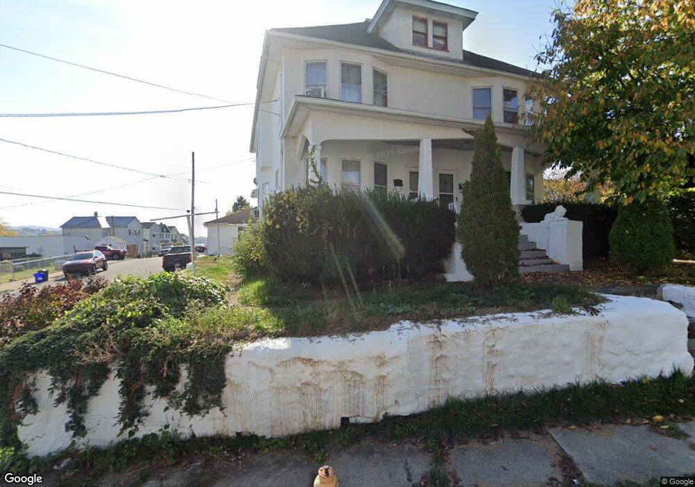
701 Landis St Unit 703 Scranton, PA 18504
Hyde Park NeighborhoodEstimated Value: $221,000 - $287,000
--
Bed
--
Bath
3,600
Sq Ft
$70/Sq Ft
Est. Value
About This Home
This home is located at 701 Landis St Unit 703, Scranton, PA 18504 and is currently estimated at $252,562, approximately $70 per square foot. 701 Landis St Unit 703 is a home located in Lackawanna County with nearby schools including Longan Elementary School, Adams Elementary School, and Frances Willard School.
Ownership History
Date
Name
Owned For
Owner Type
Purchase Details
Closed on
May 7, 2021
Sold by
Nyzio Edward and Nyzio Aniell
Bought by
Reekie Eric
Current Estimated Value
Home Financials for this Owner
Home Financials are based on the most recent Mortgage that was taken out on this home.
Original Mortgage
$126,750
Outstanding Balance
$114,867
Interest Rate
3.1%
Mortgage Type
New Conventional
Estimated Equity
$137,695
Purchase Details
Closed on
Mar 11, 2015
Sold by
Caprari Paula L and Evans Lisa A
Bought by
Nyzio Edward and Nyzio Aniell
Purchase Details
Closed on
Mar 7, 2014
Sold by
Patchoski Stanley M
Bought by
Caprari Paula L and Evans Lisa A
Create a Home Valuation Report for This Property
The Home Valuation Report is an in-depth analysis detailing your home's value as well as a comparison with similar homes in the area
Home Values in the Area
Average Home Value in this Area
Purchase History
| Date | Buyer | Sale Price | Title Company |
|---|---|---|---|
| Reekie Eric | $169,000 | None Available | |
| Nyzio Edward | $20,000 | None Available | |
| Caprari Paula L | -- | None Available |
Source: Public Records
Mortgage History
| Date | Status | Borrower | Loan Amount |
|---|---|---|---|
| Open | Reekie Eric | $126,750 |
Source: Public Records
Tax History Compared to Growth
Tax History
| Year | Tax Paid | Tax Assessment Tax Assessment Total Assessment is a certain percentage of the fair market value that is determined by local assessors to be the total taxable value of land and additions on the property. | Land | Improvement |
|---|---|---|---|---|
| 2025 | $2,716 | $8,200 | $1,700 | $6,500 |
| 2024 | $2,487 | $8,200 | $1,700 | $6,500 |
| 2023 | $2,487 | $8,200 | $1,700 | $6,500 |
| 2022 | $2,432 | $8,200 | $1,700 | $6,500 |
| 2021 | $2,432 | $8,200 | $1,700 | $6,500 |
| 2020 | $2,388 | $8,200 | $1,700 | $6,500 |
| 2019 | $2,248 | $8,200 | $1,700 | $6,500 |
| 2018 | $2,248 | $8,200 | $1,700 | $6,500 |
| 2017 | $2,210 | $8,200 | $1,700 | $6,500 |
| 2016 | $0 | $8,200 | $1,700 | $6,500 |
| 2015 | $1,344 | $8,200 | $1,700 | $6,500 |
| 2014 | -- | $8,200 | $1,700 | $6,500 |
Source: Public Records
Map
Nearby Homes
- 610 Landis St
- 625 Landis St
- 1203 Acker Ave
- 1009 1011 Acker Ave Unit L 109
- 1250 S 1252 6th
- 924 S Main Ave
- 730 W Locust St
- 1115 Watson St
- 901 Eynon St
- 705 Hampton St
- 1143 Reynolds Ave
- 1234 Bryn Mawr St Unit 11
- 727 Fellows St
- 1227 Rundle St
- 607 3rd Ave
- 1301 Sloan St
- LOT#16 Reynolds Ave
- Lot# 7 Reynolds Ave
- 1021 Fellows St
- 816 12th Ave
- 703 Landis St
- 701-703 Landis St
- 705 Landis St
- 635 Landis St
- 1112 Acker Ave
- 711 Landis St
- 1034 Acker Ave
- 631 Landis St
- 1116 Acker Ave
- 708 Landis St
- 714 Landis St
- 1030 Acker Ave
- 715 Landis St
- 715 Landis St Unit 717
- 627 Landis St
- 1118 Acker Ave
- 717 Landis St
- 1120 Acker Ave
- 716 Landis St Unit 18
- 716-718 Landis St Unit First Floor Right