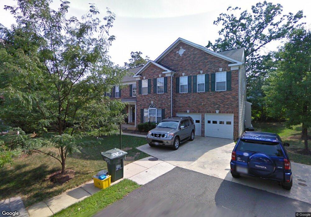
701 N Ashton St Alexandria, VA 22312
Lincolnia Hills NeighborhoodEstimated Value: $766,000 - $1,023,164
--
Bed
4
Baths
3,782
Sq Ft
$235/Sq Ft
Est. Value
About This Home
This home is located at 701 N Ashton St, Alexandria, VA 22312 and is currently estimated at $888,388, approximately $234 per square foot. 701 N Ashton St is a home located in Alexandria City with nearby schools including William Ramsay Elementary School, Francis C. Hammond Middle, and Alexandria City High School.
Ownership History
Date
Name
Owned For
Owner Type
Purchase Details
Closed on
May 31, 2002
Sold by
Calvert Homes Inc
Bought by
Bernardo Soledad L
Current Estimated Value
Home Financials for this Owner
Home Financials are based on the most recent Mortgage that was taken out on this home.
Original Mortgage
$475,150
Outstanding Balance
$202,181
Interest Rate
6.9%
Estimated Equity
$686,207
Create a Home Valuation Report for This Property
The Home Valuation Report is an in-depth analysis detailing your home's value as well as a comparison with similar homes in the area
Home Values in the Area
Average Home Value in this Area
Purchase History
| Date | Buyer | Sale Price | Title Company |
|---|---|---|---|
| Bernardo Soledad L | $559,892 | -- |
Source: Public Records
Mortgage History
| Date | Status | Borrower | Loan Amount |
|---|---|---|---|
| Open | Bernardo Soledad L | $475,150 |
Source: Public Records
Tax History Compared to Growth
Tax History
| Year | Tax Paid | Tax Assessment Tax Assessment Total Assessment is a certain percentage of the fair market value that is determined by local assessors to be the total taxable value of land and additions on the property. | Land | Improvement |
|---|---|---|---|---|
| 2025 | $10,903 | $897,292 | $378,521 | $518,771 |
| 2024 | $10,903 | $869,972 | $374,781 | $495,191 |
| 2023 | $9,657 | $869,972 | $374,781 | $495,191 |
| 2022 | $9,245 | $832,886 | $356,935 | $475,951 |
| 2021 | $9,153 | $824,592 | $353,401 | $471,191 |
| 2020 | $9,874 | $816,334 | $349,902 | $466,432 |
| 2019 | $9,233 | $817,123 | $346,438 | $470,685 |
| 2018 | $9,233 | $817,123 | $346,438 | $470,685 |
| 2017 | $9,109 | $806,099 | $346,438 | $459,661 |
| 2016 | $8,649 | $806,099 | $346,438 | $459,661 |
| 2015 | $8,321 | $797,779 | $343,008 | $454,771 |
| 2014 | $8,209 | $787,028 | $343,008 | $444,020 |
Source: Public Records
Map
Nearby Homes
- 5929 Quantrell Ave Unit 301
- 301 N Beauregard St Unit 1617
- 301 N Beauregard St Unit 1114
- 301 N Beauregard St Unit 1608
- 301 N Beauregard St Unit 1508
- 301 N Beauregard St Unit 703
- 301 N Beauregard St Unit 1605
- 523 N Armistead St Unit 102
- 525 N Armistead St Unit T2
- 431 N Armistead St Unit 502
- 431 N Armistead St Unit 211
- 519 N Armistead St Unit T1
- 5831 Quantrell Ave Unit 505
- 5801 Quantrell Ave Unit 203
- 511 N Armistead St Unit T2
- 509 N Armistead St Unit 103
- 509 N Armistead St Unit 303
- 501 N Armistead St Unit 302
- 4600 Kling Dr
- 4514 Rynex Dr
- 705 N Ashton St
- 4701 Gloucester Rd
- 715 N Ashton St
- 4705 Gloucester Rd
- 6020 Nealon Place
- 6014 Nealon Place
- 738 N Ashton St
- 401 N Beauregard St Unit 301
- 401 N Beauregard St Unit 304
- 401 N Beauregard St Unit T2
- 401 N Beauregard St Unit T3
- 401 N Beauregard St Unit 202
- 401 N Beauregard St Unit 201
- 401 N Beauregard St Unit 303
- 401 N Beauregard St Unit 104
- 401 N Beauregard St Unit 101
- 401 N Beauregard St Unit 102
- 401 N Beauregard St Unit 302
- 401 N Beauregard St Unit 204
- 401 N Beauregard St Unit 203