Estimated Value: $81,000 - $110,369
2
Beds
2
Baths
1,396
Sq Ft
$69/Sq Ft
Est. Value
About This Home
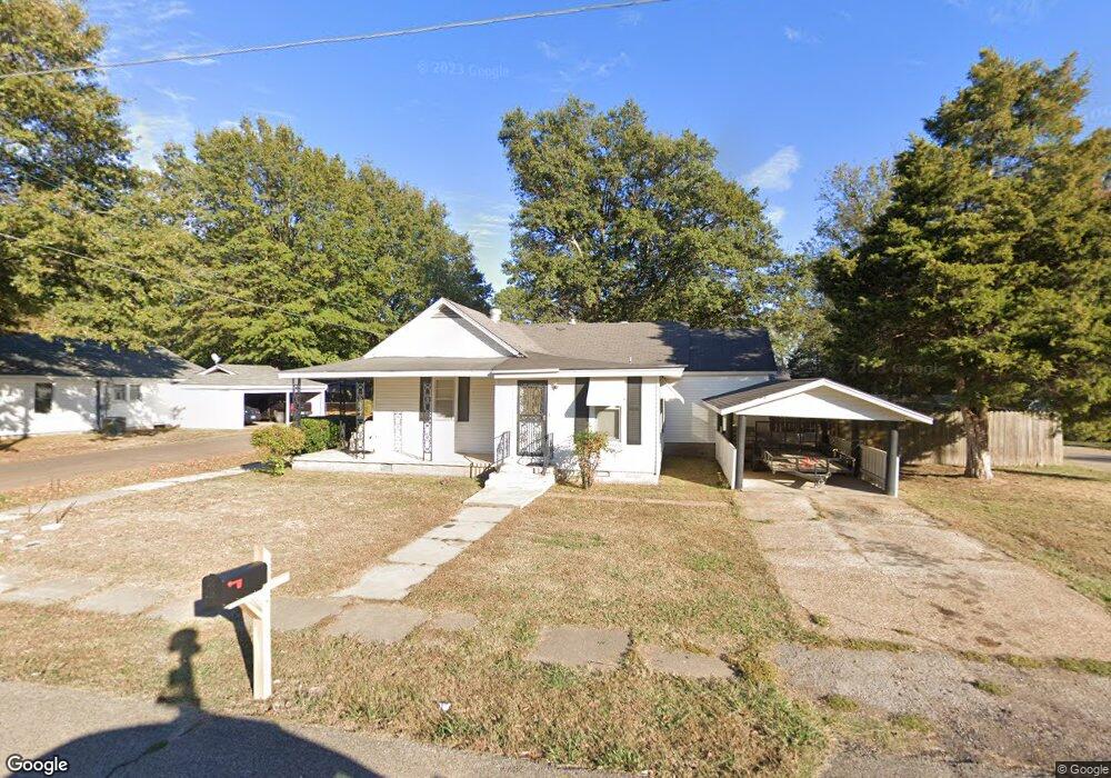
This home is located at 702 Block St S, Wynne, AR 72396 and is currently estimated at $95,842, approximately $68 per square foot. 702 Block St S is a home located in Cross County with nearby schools including Wynne Primary School, Wynne Intermediate School, and Wynne Junior High School.
Ownership History
Date
Name
Owned For
Owner Type
Purchase Details
Closed on
Oct 21, 2018
Sold by
Simpkins Bobby and Simpkins Jean
Bought by
Greer John M and Greer Debbie D
Current Estimated Value
Purchase Details
Closed on
May 30, 2018
Sold by
Barker Thelda L
Bought by
Simpkins Bobby and Simpkins Jean
Home Financials for this Owner
Home Financials are based on the most recent Mortgage that was taken out on this home.
Original Mortgage
$45,000
Interest Rate
4.5%
Purchase Details
Closed on
Nov 21, 1988
Bought by
Barker Thelda L
Create a Home Valuation Report for This Property
The Home Valuation Report is an in-depth analysis detailing your home's value as well as a comparison with similar homes in the area
Home Values in the Area
Average Home Value in this Area
Purchase History
| Date | Buyer | Sale Price | Title Company |
|---|---|---|---|
| Greer John M | $50,000 | None Available | |
| Simpkins Bobby | $55,000 | None Available | |
| Barker Thelda L | -- | -- |
Source: Public Records
Mortgage History
| Date | Status | Borrower | Loan Amount |
|---|---|---|---|
| Previous Owner | Simpkins Bobby | $45,000 |
Source: Public Records
Tax History Compared to Growth
Tax History
| Year | Tax Paid | Tax Assessment Tax Assessment Total Assessment is a certain percentage of the fair market value that is determined by local assessors to be the total taxable value of land and additions on the property. | Land | Improvement |
|---|---|---|---|---|
| 2024 | $601 | $12,160 | $2,590 | $9,570 |
| 2023 | $602 | $12,160 | $2,590 | $9,570 |
| 2022 | $602 | $12,160 | $2,590 | $9,570 |
| 2021 | $602 | $12,160 | $2,590 | $9,570 |
| 2020 | $602 | $12,160 | $2,590 | $9,570 |
| 2019 | $580 | $11,710 | $1,680 | $10,030 |
| 2018 | $580 | $11,710 | $1,680 | $10,030 |
| 2017 | $0 | $11,710 | $1,680 | $10,030 |
| 2016 | -- | $11,710 | $1,680 | $10,030 |
| 2015 | -- | $11,710 | $1,680 | $10,030 |
| 2014 | -- | $5,250 | $1,760 | $3,490 |
Source: Public Records
Map
Nearby Homes
- 704 Front St S
- 908 Block St S
- 314 Mildred Dr E
- 712 Mockingbird Ln
- 704 Mockingbird Ln
- 903 Levesque Ave E
- 701 Wren St
- 733 Martin Dr E
- 411 N Bruce St
- 607 Bruce St N
- 919 Hamilton Ave E
- 514 Poplar Ave E
- 323 Clifton Dr
- 714 Church St N
- 513 Forrest Ave E
- 106 Eldridge Ct
- 203 Crystal Ave E
- 1002 Brittney Cir
- 0 Brittney Cir Unit 43670
- 0 Brittney Cir Unit 25030957
- 704 Block St S
- 610 Block St S
- 323 Arkansas Ave E
- 322 Arkansas St
- 325 Arkansas Ave E
- 708 Block St S
- 704 Cheryl St S
- 703 Block St S
- 608 Block St S
- 322 Arkansas Ave E
- 211 Arkansas Ave E
- 324 Arkansas Ave E
- 705 Block St S
- 609 Block St S
- 327 Arkansas Ave E
- 326 Arkansas Ave E
- 707 Block St S
- 607 Block St S
- 800 Block St S
- 710 Cheryl St S