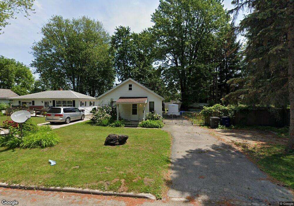
702 Elysian Ave Toledo, OH 43607
Scott Park NeighborhoodEstimated Value: $53,000 - $90,000
2
Beds
1
Bath
966
Sq Ft
$79/Sq Ft
Est. Value
About This Home
This home is located at 702 Elysian Ave, Toledo, OH 43607 and is currently estimated at $76,421, approximately $79 per square foot. 702 Elysian Ave is a home located in Lucas County with nearby schools including Keyser Elementary School, Rogers High School, and Toledo Preparatory and Fitness Academy.
Ownership History
Date
Name
Owned For
Owner Type
Purchase Details
Closed on
Jan 2, 2025
Sold by
Dura Jason R
Bought by
Jason R Dura Trust and Dura
Current Estimated Value
Purchase Details
Closed on
Nov 9, 2016
Sold by
Duara Jennifer A
Bought by
Dura Jason R
Purchase Details
Closed on
Sep 21, 2001
Sold by
Detroit Province Of The Society Of Jesus
Bought by
Dura Jason R
Purchase Details
Closed on
May 31, 2001
Sold by
Napholz Michael E
Bought by
Detroit Province Of The Society Of Jesus
Purchase Details
Closed on
Oct 15, 1990
Sold by
Napholz Michael E
Create a Home Valuation Report for This Property
The Home Valuation Report is an in-depth analysis detailing your home's value as well as a comparison with similar homes in the area
Home Values in the Area
Average Home Value in this Area
Purchase History
| Date | Buyer | Sale Price | Title Company |
|---|---|---|---|
| Jason R Dura Trust | -- | None Listed On Document | |
| Jason R Dura Trust | -- | None Listed On Document | |
| Dura Jason R | -- | None Available | |
| Dura Jason R | $37,400 | Metro Title Agency Inc | |
| Detroit Province Of The Society Of Jesus | -- | -- | |
| -- | -- | -- |
Source: Public Records
Tax History
| Year | Tax Paid | Tax Assessment Tax Assessment Total Assessment is a certain percentage of the fair market value that is determined by local assessors to be the total taxable value of land and additions on the property. | Land | Improvement |
|---|---|---|---|---|
| 2025 | -- | $13,790 | $4,305 | $9,485 |
| 2024 | $505 | $13,790 | $4,305 | $9,485 |
| 2023 | $782 | $7,630 | $3,500 | $4,130 |
| 2022 | $669 | $7,630 | $3,500 | $4,130 |
| 2021 | $673 | $7,630 | $3,500 | $4,130 |
| 2020 | $727 | $7,105 | $3,220 | $3,885 |
| 2019 | $695 | $7,105 | $3,220 | $3,885 |
| 2018 | $791 | $7,105 | $3,220 | $3,885 |
| 2017 | $850 | $8,890 | $4,025 | $4,865 |
| 2016 | $874 | $25,400 | $11,500 | $13,900 |
| 2015 | $873 | $25,400 | $11,500 | $13,900 |
| 2014 | $575 | $8,900 | $4,030 | $4,870 |
| 2013 | $575 | $8,900 | $4,030 | $4,870 |
Source: Public Records
Map
Nearby Homes
- 638 Broer Ave
- 2925 Avondale Ave
- 914 Turner Ave
- 834 Broer Ave
- 712 Underwood Ave
- 508 Ascot Ave
- 820 MacKow Dr
- 336 Conrad Ave
- 1408 Roosevelt Ave
- 1011 Alldays Ave
- 615 Cuthbert Rd
- 913 Coventry Ave
- 811 N University Ave
- 1125 Secor Rd
- 710 N Byrne Rd
- 823 N Byrne Rd
- 1814 Alvin St
- 1732 Evansdale Ave
- 1901 Alvin St
- 1917 Alvin St
- 710 Elysian Ave
- 714 Elysian Ave
- 720 Elysian Ave
- 701 Elysian Ave
- 643 Elysian Ave
- 709 Elysian Ave
- 649 Elysian Ave
- 722 Elysian Ave
- 713 Elysian Ave
- 622 Elysian Ave
- 631 Elysian Ave
- 715 Elysian Ave
- 728 Elysian Ave
- 627 Elysian Ave
- 618 Elysian Ave
- 634 Elysian Ave
- 723 Elysian Ave
- 715 Burbank Dr
- 619 Elysian Ave
- 613 Elysian Ave
Your Personal Tour Guide
Ask me questions while you tour the home.