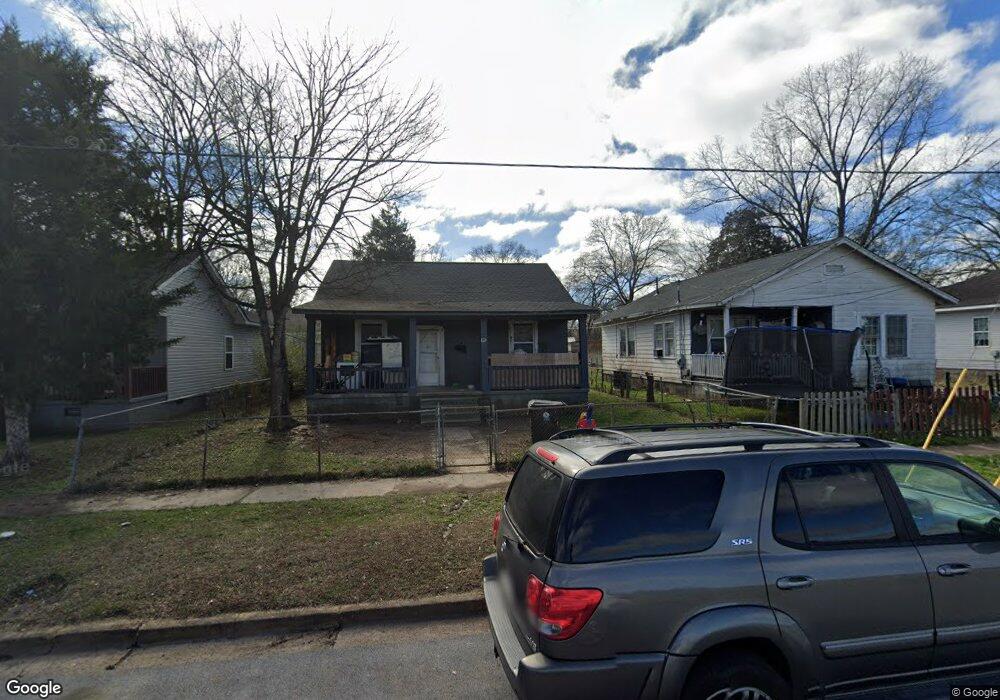
702 La Due St Cedartown, GA 30125
Estimated Value: $109,978 - $166,000
2
Beds
1
Bath
1,080
Sq Ft
$122/Sq Ft
Est. Value
About This Home
This home is located at 702 La Due St, Cedartown, GA 30125 and is currently estimated at $131,495, approximately $121 per square foot. 702 La Due St is a home located in Polk County with nearby schools including Cedar Christian School and Vineyard Harvester Christian Academy.
Ownership History
Date
Name
Owned For
Owner Type
Purchase Details
Closed on
Sep 29, 2020
Sold by
J & A Rental Properties Llc
Bought by
Segura Alexander and Segura Celenia
Current Estimated Value
Purchase Details
Closed on
Mar 18, 2015
Sold by
Vfc Properties 31 Llc
Bought by
J & A Rental Properties Llc
Purchase Details
Closed on
Mar 7, 2014
Sold by
Smith Gary P *M and Smith P
Bought by
Vfc Properties 31 Llc
Purchase Details
Closed on
Oct 8, 1999
Sold by
Kaj Inc
Bought by
Smith Gary P
Purchase Details
Closed on
Oct 15, 1998
Sold by
Mcclain Carlton G and Mcclain Jean S
Bought by
Kaj Inc
Purchase Details
Closed on
Jun 1, 1995
Sold by
Moss Bobbie W
Bought by
Mcclain Carlton
Purchase Details
Closed on
Apr 3, 1995
Sold by
Whisenhunt Jewell
Bought by
Moss Bobbie W
Purchase Details
Closed on
Oct 24, 1950
Bought by
Whisenhunt Jewell
Create a Home Valuation Report for This Property
The Home Valuation Report is an in-depth analysis detailing your home's value as well as a comparison with similar homes in the area
Home Values in the Area
Average Home Value in this Area
Purchase History
| Date | Buyer | Sale Price | Title Company |
|---|---|---|---|
| Segura Alexander | -- | -- | |
| J & A Rental Properties Llc | $575,000 | -- | |
| Vfc Properties 31 Llc | -- | -- | |
| Smith Gary P | $29,600 | -- | |
| Kaj Inc | -- | -- | |
| Mcclain Carlton | $15,000 | -- | |
| Moss Bobbie W | -- | -- | |
| Whisenhunt Jewell | -- | -- |
Source: Public Records
Tax History Compared to Growth
Tax History
| Year | Tax Paid | Tax Assessment Tax Assessment Total Assessment is a certain percentage of the fair market value that is determined by local assessors to be the total taxable value of land and additions on the property. | Land | Improvement |
|---|---|---|---|---|
| 2024 | $900 | $28,506 | $4,000 | $24,506 |
| 2023 | $421 | $12,144 | $400 | $11,744 |
| 2022 | $247 | $10,403 | $400 | $10,003 |
| 2021 | $250 | $10,403 | $400 | $10,003 |
| 2020 | $251 | $10,403 | $400 | $10,003 |
| 2019 | $139 | $5,185 | $599 | $4,586 |
| 2018 | $138 | $5,026 | $599 | $4,427 |
| 2017 | $137 | $5,026 | $599 | $4,427 |
| 2016 | $76 | $5,026 | $599 | $4,427 |
| 2015 | $140 | $5,135 | $599 | $4,536 |
| 2014 | $141 | $5,135 | $599 | $4,536 |
Source: Public Records
Map
Nearby Homes
- 382 5th St
- 293 4th St
- 119 Jackson St
- 309 Walnut St
- 605 W Girard Ave
- 421 Wissahickon Ave
- 258 Chestnut St
- 305 N Cave Spring St
- 443 N Cave Spring St
- 214 Victoria Ave
- 328 Mountain Home Rd
- 601 Mountain Home Rd
- 408 N College St
- 144 Marshall St
- 228 Marshall St
- 607 N College St
- 2460 Hidden Creek Rd
- 214 Jule Peek Ave
- 634 Georgia Ave
- 634 Georgia Ave Unit 123