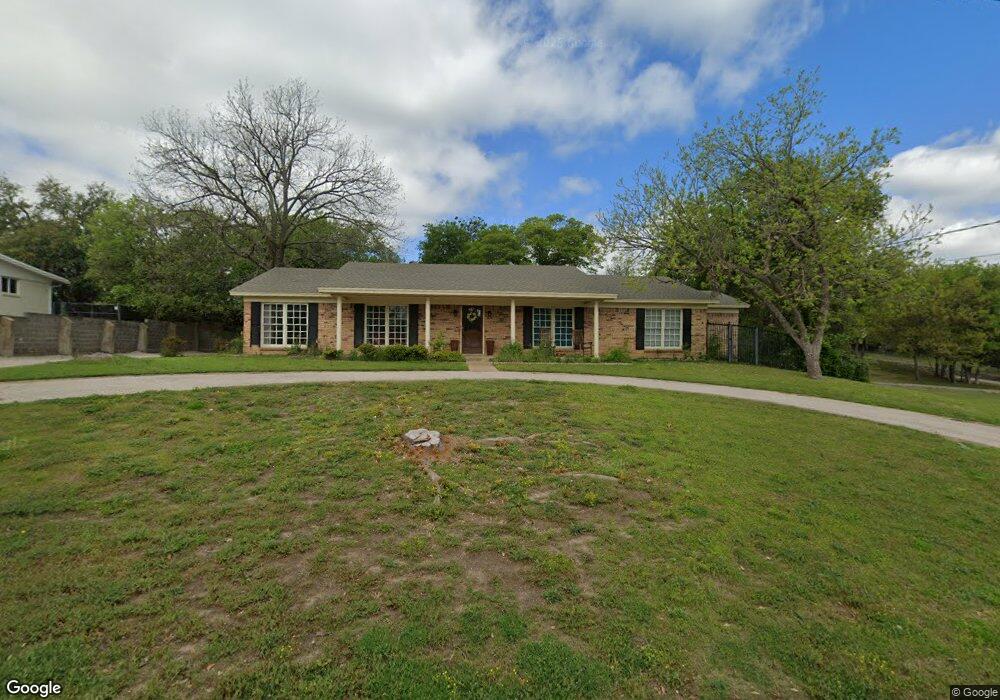
702 Norton St Weatherford, TX 76086
Estimated Value: $437,217 - $493,000
3
Beds
2
Baths
2,258
Sq Ft
$201/Sq Ft
Est. Value
About This Home
This home is located at 702 Norton St, Weatherford, TX 76086 and is currently estimated at $454,304, approximately $201 per square foot. 702 Norton St is a home located in Parker County with nearby schools including Curtis Elementary School, Hall Middle School, and Weatherford High School.
Ownership History
Date
Name
Owned For
Owner Type
Purchase Details
Closed on
May 23, 2018
Sold by
Chandler Kathy Curtis
Bought by
Post Richard H
Current Estimated Value
Home Financials for this Owner
Home Financials are based on the most recent Mortgage that was taken out on this home.
Original Mortgage
$293,785
Outstanding Balance
$252,959
Interest Rate
4.4%
Mortgage Type
VA
Estimated Equity
$201,345
Purchase Details
Closed on
Jul 22, 1994
Bought by
Chandler Kathy C
Purchase Details
Closed on
Dec 16, 1987
Bought by
Chandler Kathy C
Create a Home Valuation Report for This Property
The Home Valuation Report is an in-depth analysis detailing your home's value as well as a comparison with similar homes in the area
Home Values in the Area
Average Home Value in this Area
Purchase History
| Date | Buyer | Sale Price | Title Company |
|---|---|---|---|
| Post Richard H | -- | Seweli Title Co | |
| Chandler Kathy C | -- | -- | |
| Chandler Kathy C | -- | -- |
Source: Public Records
Mortgage History
| Date | Status | Borrower | Loan Amount |
|---|---|---|---|
| Open | Post Richard H | $293,785 |
Source: Public Records
Tax History Compared to Growth
Tax History
| Year | Tax Paid | Tax Assessment Tax Assessment Total Assessment is a certain percentage of the fair market value that is determined by local assessors to be the total taxable value of land and additions on the property. | Land | Improvement |
|---|---|---|---|---|
| 2025 | $4,550 | $407,443 | -- | -- |
| 2024 | $4,550 | $370,403 | -- | -- |
| 2023 | $4,550 | $336,730 | $0 | $0 |
| 2022 | $6,790 | $306,120 | $31,750 | $274,370 |
| 2021 | $7,351 | $306,120 | $31,750 | $274,370 |
| 2020 | $6,773 | $280,320 | $31,750 | $248,570 |
| 2019 | $7,158 | $280,320 | $31,750 | $248,570 |
| 2018 | $5,513 | $214,930 | $31,750 | $183,180 |
| 2017 | $5,231 | $214,930 | $31,750 | $183,180 |
| 2016 | $4,755 | $180,730 | $31,750 | $148,980 |
| 2015 | $4,287 | $180,730 | $31,750 | $148,980 |
| 2014 | $4,189 | $175,160 | $31,750 | $143,410 |
Source: Public Records
Map
Nearby Homes
- 213 Jefferson St
- 221 Jefferson St
- 208 Jefferson St
- 237 Jefferson St
- 220 Jefferson St
- 819 Norton St
- 122 Rachel Rd
- 514 W Josephine St
- 905 S Lamar St
- 904 S Brazos St
- 504 W Lee Ave
- 1012 Keechi St
- 616 W Baylor St
- 514 W Baylor St
- 220 S Merrimac
- 1009 S Brazos St
- 824 S Alamo St
- 1113 Keechi St
- 407 W Columbia St
- 905 W Oak St