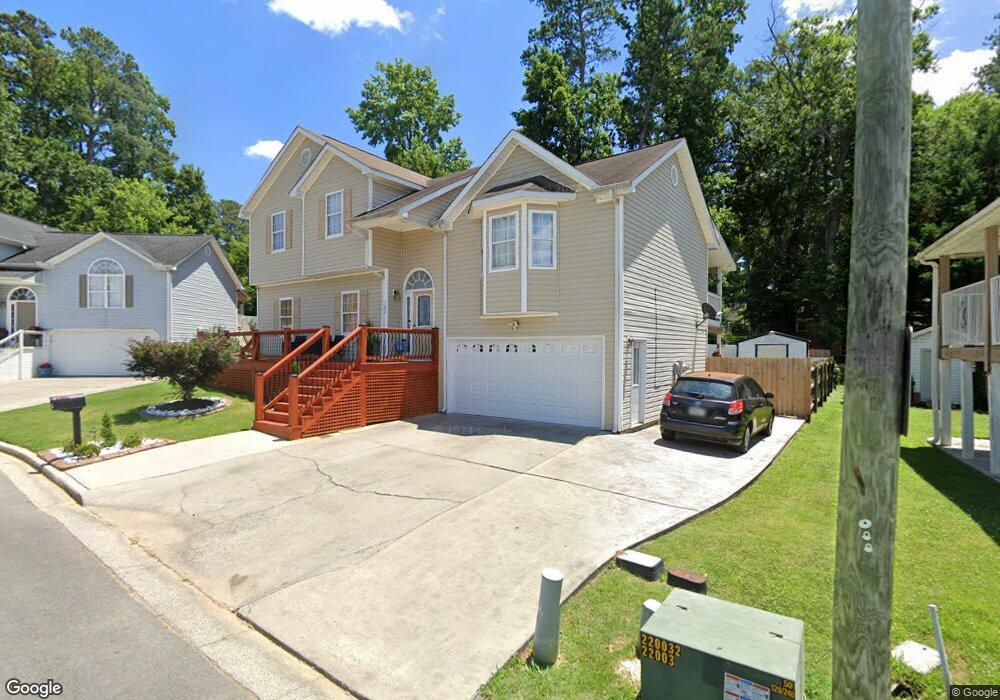
702 Woodland Cir Dalton, GA 30721
Estimated Value: $197,000 - $261,000
--
Bed
2
Baths
1,070
Sq Ft
$218/Sq Ft
Est. Value
About This Home
This home is located at 702 Woodland Cir, Dalton, GA 30721 and is currently estimated at $233,298, approximately $218 per square foot. 702 Woodland Cir is a home located in Whitfield County with nearby schools including Park Creek Elementary School, Dalton Middle School, and Dalton High School.
Ownership History
Date
Name
Owned For
Owner Type
Purchase Details
Closed on
Sep 30, 2001
Sold by
Onstar Construction In
Bought by
Uriostegui Efrain and Uriostegui Elizabeth
Current Estimated Value
Purchase Details
Closed on
Apr 5, 2001
Sold by
Onstar Development Inc
Bought by
Onstar Construction In
Purchase Details
Closed on
Aug 21, 2000
Sold by
Greene George H
Bought by
Onstar Development Inc
Create a Home Valuation Report for This Property
The Home Valuation Report is an in-depth analysis detailing your home's value as well as a comparison with similar homes in the area
Home Values in the Area
Average Home Value in this Area
Purchase History
| Date | Buyer | Sale Price | Title Company |
|---|---|---|---|
| Uriostegui Efrain | $109,900 | -- | |
| Onstar Construction In | $18,000 | -- | |
| Onstar Development Inc | -- | -- |
Source: Public Records
Tax History Compared to Growth
Tax History
| Year | Tax Paid | Tax Assessment Tax Assessment Total Assessment is a certain percentage of the fair market value that is determined by local assessors to be the total taxable value of land and additions on the property. | Land | Improvement |
|---|---|---|---|---|
| 2024 | $1,926 | $79,956 | $8,400 | $71,556 |
| 2023 | $1,926 | $58,084 | $8,400 | $49,684 |
| 2022 | $1,554 | $52,516 | $8,400 | $44,116 |
| 2021 | $1,557 | $52,516 | $8,400 | $44,116 |
| 2020 | $1,470 | $48,752 | $5,400 | $43,352 |
| 2019 | $1,512 | $48,752 | $5,400 | $43,352 |
| 2018 | $1,529 | $48,752 | $5,400 | $43,352 |
| 2017 | $1,466 | $48,752 | $5,400 | $43,352 |
| 2016 | $1,331 | $44,841 | $6,300 | $38,541 |
| 2014 | $1,251 | $44,841 | $6,300 | $38,541 |
| 2013 | -- | $44,840 | $6,300 | $38,540 |
Source: Public Records
Map
Nearby Homes
- 606 Virginia Ave
- 502 E Woodland Dr
- 533 Underwood St
- 601 Stillwood Dr
- 916 Avenue E
- 404 Paige St
- 825 Martin Luther King jr Blvd
- 928 Avenue C
- 301B Fields Ave
- 940 Avenue E
- 717 Morningside Dr
- 204 N Bogle St
- 416 Sassafras St
- 1326 Veterans Dr
- 519 Abigail St
- 311 Shady Ln
- 1119 Acme St
- 00 Glenwood Ave
- 0 Underwood St Unit 129860
- 711 E Morris St
- 700 Woodland Cir
- 704 Woodland Cir
- 613 W Woodland Dr
- 703 Woodland Cir
- 706 Woodland Cir
- 615 W Woodland Dr
- 701 Woodland Cir
- 744 Woodland Cir
- 611 W Woodland Dr
- 708 Woodland Cir
- 705 Woodland Cir
- 617 W Woodland Dr
- 627 1/2 Virginia Ave
- 609 Virginia Ave
- 723 Woodland Cir
- 707 Woodland Cir
- 710 Woodland Cir
- 615 Virginia Ave
- 742 Woodland Cir
- 721 Woodland Cir