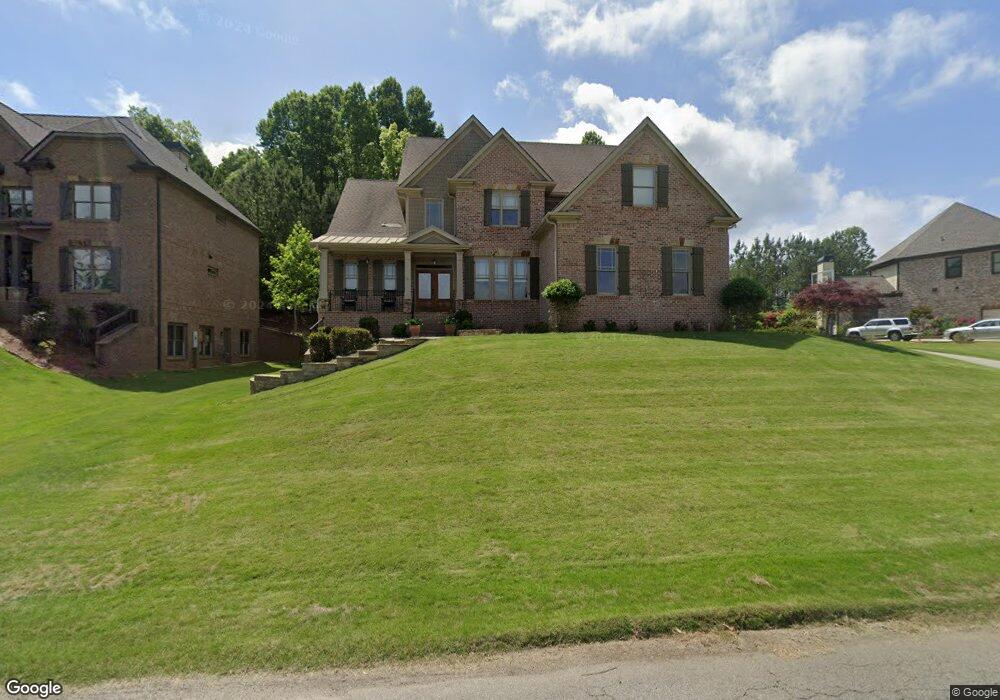
7020 Collins Point Rd Cumming, GA 30041
Estimated Value: $842,000 - $1,194,000
5
Beds
4
Baths
4,393
Sq Ft
$235/Sq Ft
Est. Value
About This Home
This home is located at 7020 Collins Point Rd, Cumming, GA 30041 and is currently estimated at $1,033,359, approximately $235 per square foot. 7020 Collins Point Rd is a home located in Forsyth County with nearby schools including Chattahoochee Elementary School and Little Mill Middle School.
Ownership History
Date
Name
Owned For
Owner Type
Purchase Details
Closed on
Oct 9, 2009
Sold by
Branch Bkng & Trust
Bought by
Seaney Shawn
Current Estimated Value
Home Financials for this Owner
Home Financials are based on the most recent Mortgage that was taken out on this home.
Original Mortgage
$352,006
Outstanding Balance
$228,088
Interest Rate
4.93%
Mortgage Type
FHA
Estimated Equity
$805,271
Create a Home Valuation Report for This Property
The Home Valuation Report is an in-depth analysis detailing your home's value as well as a comparison with similar homes in the area
Home Values in the Area
Average Home Value in this Area
Purchase History
| Date | Buyer | Sale Price | Title Company |
|---|---|---|---|
| Seaney Shawn | $358,500 | -- | |
| Branch Bkng & Trust Co | -- | -- |
Source: Public Records
Mortgage History
| Date | Status | Borrower | Loan Amount |
|---|---|---|---|
| Open | Branch Bkng & Trust Co | $352,006 |
Source: Public Records
Tax History
| Year | Tax Paid | Tax Assessment Tax Assessment Total Assessment is a certain percentage of the fair market value that is determined by local assessors to be the total taxable value of land and additions on the property. | Land | Improvement |
|---|---|---|---|---|
| 2025 | $7,424 | $383,904 | $52,000 | $331,904 |
| 2024 | $7,424 | $370,800 | $48,000 | $322,800 |
| 2023 | $6,133 | $314,236 | $40,000 | $274,236 |
Source: Public Records
Map
Nearby Homes
- 6870 Bragg Rd
- 7208 Collins Dr
- 6860 Nantucket Cove
- 7223 Flowery Branch Rd
- 6685 Driskell Rd
- 7270 Flowery Branch Rd
- 6965 Flowery Branch Rd
- 6705 Shady Grove Rd
- 6700 Shady Grove Rd
- 7585 Yacht Club Dr
- 0 Indian Knoll Rd Unit 7638013
- 6710 Timber Trail
- 6340 Barberry Hill Dr
- 7625 Breeze Bay Rd
- 7620 Breeze Bay Rd
- 7160 Shady Grove Rd
- 7125 Heard Rd
- 6930 Heard Rd
- 9230 Four Mile Creek Rd
- 0 Raines Dr Unit 7441495
- 7030 Collins Point Rd
- 7025 Collins Point Rd
- 7010 Collins Point Rd
- 7015 Collins Point Rd
- 7025 Bragg Rd
- 7050 Collins Point Rd
- 6910 Lighthouse Point
- 7010 Bragg Rd
- 000 Bragg Rd
- N/A Bragg Rd
- 7020 Lighthouse Point
- 6920B Lighthouse Point Unit B
- 6920 Lighthouse Point Unit B
- 6920 Lighthouse Point Unit A
- 6920 Lighthouse Point
- 7110 Biscayne Dr Unit 8
- 7110 Biscayne Dr
- 7090 Collins Point Rd
- 7100 Biscayne Dr
- 6910 Bragg Rd
Your Personal Tour Guide
Ask me questions while you tour the home.