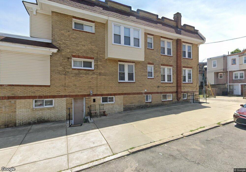
7038 Forrest Ave Philadelphia, PA 19138
West Oak Lane NeighborhoodEstimated Value: $259,000 - $337,000
--
Bed
--
Bath
1,872
Sq Ft
$159/Sq Ft
Est. Value
About This Home
This home is located at 7038 Forrest Ave, Philadelphia, PA 19138 and is currently estimated at $298,000, approximately $159 per square foot. 7038 Forrest Ave is a home located in Philadelphia County with nearby schools including William Rowen School, Gen. Louis Wagner Middle School, and Martin Luther King High School.
Ownership History
Date
Name
Owned For
Owner Type
Purchase Details
Closed on
May 18, 2010
Sold by
Cannon Calvin L
Bought by
Corestates Group Llc
Current Estimated Value
Purchase Details
Closed on
Dec 8, 2008
Sold by
Edwards R C and City Of Philadelphia
Bought by
Cannon Calvin L
Purchase Details
Closed on
Jan 8, 2001
Sold by
Edwards Ronald J
Bought by
Edwards R C
Create a Home Valuation Report for This Property
The Home Valuation Report is an in-depth analysis detailing your home's value as well as a comparison with similar homes in the area
Home Values in the Area
Average Home Value in this Area
Purchase History
| Date | Buyer | Sale Price | Title Company |
|---|---|---|---|
| Corestates Group Llc | $52,500 | None Available | |
| Cannon Calvin L | $48,100 | None Available | |
| Edwards R C | -- | -- |
Source: Public Records
Tax History Compared to Growth
Tax History
| Year | Tax Paid | Tax Assessment Tax Assessment Total Assessment is a certain percentage of the fair market value that is determined by local assessors to be the total taxable value of land and additions on the property. | Land | Improvement |
|---|---|---|---|---|
| 2026 | $2,657 | $260,000 | $52,000 | $208,000 |
| 2025 | $2,657 | $260,000 | $52,000 | $208,000 |
| 2024 | $2,657 | $260,000 | $52,000 | $208,000 |
| 2023 | $2,657 | $189,800 | $37,960 | $151,840 |
| 2022 | $2,228 | $189,800 | $37,960 | $151,840 |
| 2021 | $2,228 | $0 | $0 | $0 |
| 2020 | $2,228 | $0 | $0 | $0 |
| 2019 | $2,199 | $0 | $0 | $0 |
| 2018 | $1,755 | $0 | $0 | $0 |
| 2017 | $1,755 | $0 | $0 | $0 |
| 2016 | $1,755 | $0 | $0 | $0 |
| 2015 | $1,680 | $0 | $0 | $0 |
| 2014 | -- | $125,400 | $14,476 | $110,924 |
| 2012 | -- | $12,896 | $3,075 | $9,821 |
Source: Public Records
Map
Nearby Homes
- 7092 Forrest Ave
- 7001 Limekiln Pike
- 7206 Forrest Ave
- 7016 Andrews Ave
- 6944 Cedar Park Ave
- 7349 E Walnut Ln
- 7159 N 20th St
- 7188 N Uber St
- 6908 Ogontz Ave
- 6905 Forrest Ave
- 1839 E Pastorius St
- 7245 Ogontz Ave
- 1652 E Walnut Ln
- 7313 Limekiln Pike
- 1821 E Tulpehocken St
- 6838 Ogontz Ave
- 6869 Forrest Ave
- 1822 Nolan St
- 1623 Middleton St
- 1996 73rd Ave
- 7036 Forrest Ave
- 7034 Forrest Ave
- 7032 Forrest Ave
- 7030 Forrest Ave
- 2001 Middleton St
- 7028 Forrest Ave
- 7026 Forrest Ave
- 7039 Cedar Park Ave
- 7037 Cedar Park Ave
- 7050 Forrest Ave
- 7035 Cedar Park Ave
- 7033 Cedar Park Ave
- 7024 Forrest Ave
- 7031 Cedar Park Ave
- 7052 Forrest Ave
- 7101 Cedar Park Ave
- 7029 Cedar Park Ave
- 7054 Forrest Ave Unit 1
- 7054 Forrest Ave
- 7022 Forrest Ave