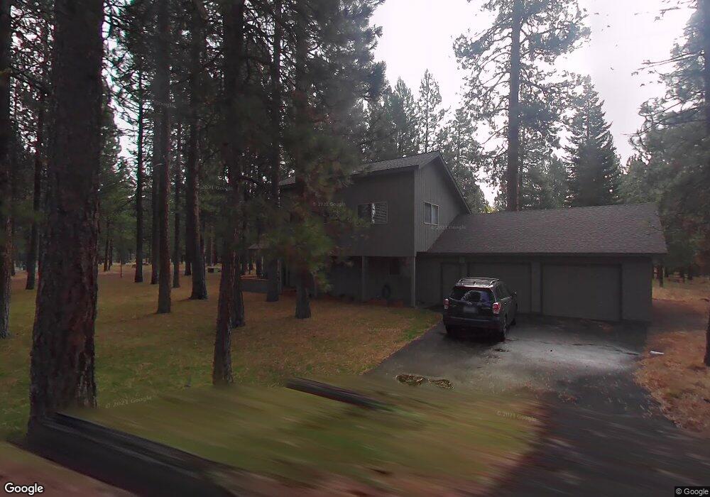
70490 Alum Root Sisters, OR 97759
Estimated Value: $877,000 - $1,015,000
4
Beds
2
Baths
1,885
Sq Ft
$495/Sq Ft
Est. Value
About This Home
This home is located at 70490 Alum Root, Sisters, OR 97759 and is currently estimated at $933,391, approximately $495 per square foot. 70490 Alum Root is a home with nearby schools including Sisters Elementary School, Sisters Middle School, and Sisters High School.
Ownership History
Date
Name
Owned For
Owner Type
Purchase Details
Closed on
Oct 16, 2024
Sold by
Meade Paul
Bought by
Meade Family Trust and Meade
Current Estimated Value
Purchase Details
Closed on
May 8, 2018
Sold by
Meade Murray E and Murray E Meade Revocable Trust
Bought by
Meade Paul
Purchase Details
Closed on
Apr 25, 2018
Sold by
Meade Murrya E
Bought by
Meade Paul
Purchase Details
Closed on
Apr 11, 2012
Sold by
Meade Paul and Meade Roslyn
Bought by
Meade Paul J
Purchase Details
Closed on
Dec 31, 2008
Sold by
Meade Murray E
Bought by
Meade Paul and Meade Roslyn
Create a Home Valuation Report for This Property
The Home Valuation Report is an in-depth analysis detailing your home's value as well as a comparison with similar homes in the area
Home Values in the Area
Average Home Value in this Area
Purchase History
| Date | Buyer | Sale Price | Title Company |
|---|---|---|---|
| Meade Family Trust | -- | None Listed On Document | |
| Meade Paul | $252,500 | None Listed On Document | |
| Meade Paul | $252,500 | None Available | |
| Meade Paul J | -- | None Available | |
| Meade Paul | $335,000 | Accommodation |
Source: Public Records
Tax History Compared to Growth
Tax History
| Year | Tax Paid | Tax Assessment Tax Assessment Total Assessment is a certain percentage of the fair market value that is determined by local assessors to be the total taxable value of land and additions on the property. | Land | Improvement |
|---|---|---|---|---|
| 2025 | $7,584 | $469,980 | -- | -- |
| 2024 | $7,177 | $456,300 | -- | -- |
| 2023 | $6,885 | $443,010 | $0 | $0 |
| 2022 | $6,592 | $417,590 | $0 | $0 |
| 2021 | $6,461 | $405,430 | $0 | $0 |
| 2020 | $6,131 | $405,430 | $0 | $0 |
| 2019 | $5,944 | $393,630 | $0 | $0 |
| 2018 | $5,782 | $382,170 | $0 | $0 |
| 2017 | $5,606 | $371,040 | $0 | $0 |
| 2016 | $5,525 | $360,240 | $0 | $0 |
| 2015 | $5,188 | $349,750 | $0 | $0 |
| 2014 | $5,038 | $339,570 | $0 | $0 |
Source: Public Records
Map
Nearby Homes
- 70474 Alum Root
- 70661 Steeple Bush Unit SM202
- 70332 Sword Fern Unit GM 245
- 13699 Speedwell Unit GM90
- 70701 Pasque Flower Unit SM94
- 13582 Hollyhock Unit BBH13
- 14023 Hawks Beard
- 70786 Blazing Star Unit RR 64
- 13584 Nine Bark
- 70780 Bitter Root
- 13579 Sundew Unit SM34
- 70305 Arvensis Unit GM 348
- 70440 Linnaea Borealis Unit GM395
- 13391 Anapholis Unit GM 419
- 70179 Atherium
- 13251 Snowbrush Unit GH 266
- 70948 Mules Ear
- 13400 Foxtail Unit GCC 101
- 13400 Foxtail Unit GCC83
- 13400 Foxtail Unit 99
- 13745 Ground Fir
- 13745 Ground Fir Unit GM50
- 70484 Alum Root
- 70487 Alum Root
- 70483 Alum Root
- 70474 Alum Root Unit GM 53
- 70479 Alum Root
- 13753 Ground Fir Unit GM 49
- 13753 Ground Fir Gm49
- 13750 Ground Fir
- 70475 Alum Root
- 70475 Alum Root Gm 39
- 70468 Alum Root
- 13762 Ground Fir Unit GM44
- 13757 Ground Fir
- 70471 Alum Root
- 70407 Twistedstock
- 13661 Hawks Beard Unit LC30
- 13669 Hawks Beard Unit 37/38
- 13627 Hawks Beard