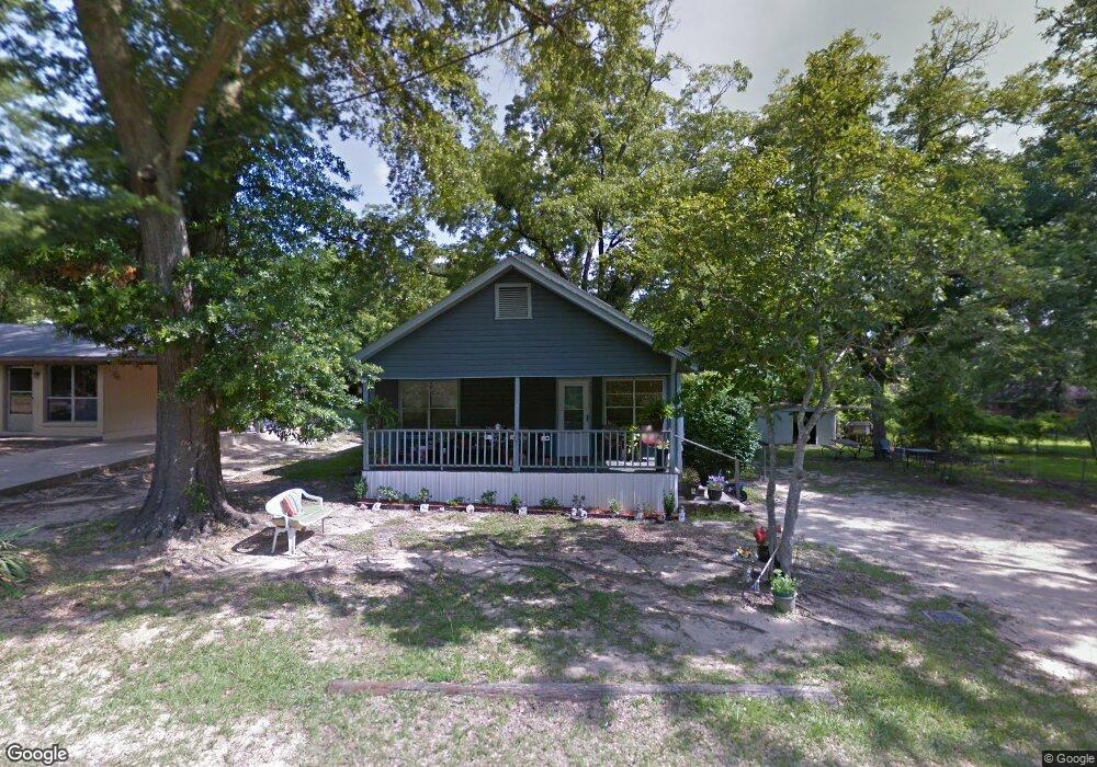
705 E Line Ave Ruston, LA 71270
Estimated Value: $84,204 - $141,000
3
Beds
1
Bath
1,424
Sq Ft
$70/Sq Ft
Est. Value
About This Home
This home is located at 705 E Line Ave, Ruston, LA 71270 and is currently estimated at $99,551, approximately $69 per square foot. 705 E Line Ave is a home located in Lincoln Parish with nearby schools including Ruston Elementary School, Hillcrest Elementary School, and Ruston Junior High School.
Ownership History
Date
Name
Owned For
Owner Type
Purchase Details
Closed on
Jun 20, 2024
Sold by
Jackson Robin
Bought by
Robinson Nick and Robinson Brandy T
Current Estimated Value
Purchase Details
Closed on
Jan 4, 2011
Sold by
First National Bank
Bought by
Jackson Robin L
Purchase Details
Closed on
May 12, 2010
Sold by
Waller Donnie
Bought by
T/T Land Company
Purchase Details
Closed on
Sep 17, 2007
Sold by
Buggs Billy R
Bought by
Hill Edward Lanier
Create a Home Valuation Report for This Property
The Home Valuation Report is an in-depth analysis detailing your home's value as well as a comparison with similar homes in the area
Purchase History
| Date | Buyer | Sale Price | Title Company |
|---|---|---|---|
| Robinson Nick | -- | None Listed On Document | |
| Jackson Robin L | $54,000 | None Available | |
| T/T Land Company | $537 | None Available | |
| Hill Edward Lanier | $23,500 | None Available |
Source: Public Records
Tax History
| Year | Tax Paid | Tax Assessment Tax Assessment Total Assessment is a certain percentage of the fair market value that is determined by local assessors to be the total taxable value of land and additions on the property. | Land | Improvement |
|---|---|---|---|---|
| 2025 | $324 | $3,790 | $812 | $2,978 |
| 2024 | $324 | $3,790 | $812 | $2,978 |
| 2023 | $401 | $4,508 | $508 | $4,000 |
| 2022 | $403 | $4,508 | $508 | $4,000 |
| 2021 | $373 | $4,508 | $508 | $4,000 |
| 2020 | $359 | $4,324 | $580 | $3,744 |
| 2019 | $351 | $4,324 | $580 | $3,744 |
| 2018 | $342 | $4,324 | $580 | $3,744 |
| 2017 | $342 | $4,324 | $580 | $3,744 |
| 2016 | $341 | $0 | $0 | $0 |
| 2015 | $313 | $3,644 | $580 | $3,064 |
| 2013 | $318 | $3,644 | $580 | $3,064 |
Source: Public Records
Map
Nearby Homes
- 000 Eastland Ave
- 102 Calvin Ave Unit 707 S Farmerville St
- 900 Cornell Ave
- 911 S Farmerville St
- 509 2nd Ave
- 108 S Farmerville St
- 1401 Wyoming Ave
- 1200 E Mississippi Ave
- 203 E California Ave
- 716 Jody Ct
- 1304 Lewis St
- 1203 Kenwood Dr
- 500 S Bonner St
- 615 S Vienna St Unit 615 1/2 S. Vienna St
- 000 Louisiana 33
- 322 N Bernard St
- 000 S Vienna St
- 300 E Georgia Ave Unit Georgia Avenue
- 5616 U S Highway 167
- 10540 U S Highway 167
- 703 E Line Ave
- 608 Mcallister St
- 610 Mcallister St
- 606 Mcallister St
- 604 Mcallister St
- 708 E California Ave
- 700 E Line Ave
- 706 E California Ave
- 602 Mcallister St
- 704 E California Ave
- 600 Mcallister St
- 800 E California Ave
- 127 Calvin Ave
- 802 E California Ave
- 607 Garden St
- 125 Calvin Ave
- 125 Calvin Ave
- 609 Garden St
- 711 E California Plant Rd
- 804 E California Ave
Your Personal Tour Guide
Ask me questions while you tour the home.