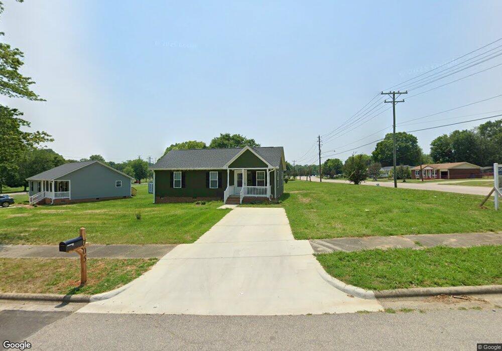
705 E Monroe St Salisbury, NC 28144
Estimated Value: $210,000 - $241,358
--
Bed
--
Bath
1,120
Sq Ft
$201/Sq Ft
Est. Value
About This Home
This home is located at 705 E Monroe St, Salisbury, NC 28144 and is currently estimated at $225,340, approximately $201 per square foot. 705 E Monroe St is a home with nearby schools including Elizabeth Duncan Koontz Elementary School, Knox Middle School, and North Rowan Middle School.
Ownership History
Date
Name
Owned For
Owner Type
Purchase Details
Closed on
Nov 2, 2022
Sold by
Campbell Deborah Elaine P
Bought by
Eddie Hampton Investment Properties Llc
Current Estimated Value
Purchase Details
Closed on
Oct 5, 2022
Sold by
Rowan County
Bought by
Kania Richard J and Ordonez Jorge
Purchase Details
Closed on
Nov 16, 2016
Sold by
City Of Salisbury
Bought by
Habitat For Humanity Of Rowan Cnty North
Create a Home Valuation Report for This Property
The Home Valuation Report is an in-depth analysis detailing your home's value as well as a comparison with similar homes in the area
Home Values in the Area
Average Home Value in this Area
Purchase History
| Date | Buyer | Sale Price | Title Company |
|---|---|---|---|
| Eddie Hampton Investment Properties Llc | $575,000 | -- | |
| Smith James Quincy | -- | -- | |
| Sutton Marty E | -- | None Listed On Document | |
| Kania Richard J | $28,100 | -- | |
| Jym Export | $28,100 | None Listed On Document | |
| Habitat For Humanity Of Rowan Cnty North | -- | None Available |
Source: Public Records
Tax History Compared to Growth
Tax History
| Year | Tax Paid | Tax Assessment Tax Assessment Total Assessment is a certain percentage of the fair market value that is determined by local assessors to be the total taxable value of land and additions on the property. | Land | Improvement |
|---|---|---|---|---|
| 2025 | $1,961 | $163,924 | $23,920 | $140,004 |
| 2024 | $1,961 | $163,924 | $23,920 | $140,004 |
| 2023 | $286 | $23,920 | $23,920 | $0 |
| 2022 | $264 | $19,136 | $19,136 | $0 |
| 2021 | $264 | $19,136 | $19,136 | $0 |
| 2020 | $264 | $19,136 | $19,136 | $0 |
| 2019 | $264 | $19,136 | $19,136 | $0 |
| 2018 | $264 | $19,136 | $19,136 | $0 |
| 2017 | $0 | $19,136 | $19,136 | $0 |
| 2016 | -- | $19,136 | $19,136 | $0 |
| 2015 | -- | $19,136 | $19,136 | $0 |
| 2014 | -- | $19,136 | $19,136 | $0 |
Source: Public Records
Map
Nearby Homes
- 430 E Horah St Unit 32
- 301 S Shaver St
- 403 S Long St
- 420 E Bank St
- 409 E Fisher St
- 0 Harrel St
- 5 Cooper St
- 205 N Martin Luther King jr Ave
- 720 E Council St
- 7 Cooper St
- 9 Cooper St
- 500 W Council St
- 119 S Lee St Unit 3
- 705 E Liberty St
- 501 S Main St
- 613 E Liberty St
- 209 S Main St
- 300 S Main St Unit K
- 316 N Clay St
- 115 W Thomas St
- 709 E Monroe St
- 515 S Martin Luther King jr Ave
- 417 S Martin Luther King jr Ave
- 516 S Martin Luther King jr Ave
- 413 S Martin Luther King jr Ave
- 522 S Martin Luther King jr Ave
- 523 S Martin Luther King jr Ave
- 526 S Martin Luther King jr Ave
- 527 N Martin Luther King jr Ave
- 527 S Martin Luther King jr Ave
- 405 S Martin Luther King jr Ave
- 611 E Monroe St
- 517 S Clay St
- 530 S Martin Luther King jr Ave
- 531 S Martin Luther King jr Ave
- 531 S Martin Luther King jr Ave
- 531 S Martin Luther King jr Ave Unit L-17
- 519 S Clay St
- 401 S Martin Luther King jr Ave
- 431 S Clay St