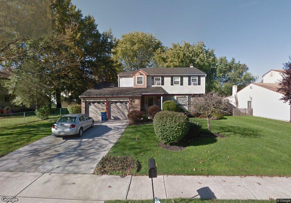
705 General Scott Rd King of Prussia, PA 19406
Estimated Value: $640,429 - $681,000
4
Beds
4
Baths
2,433
Sq Ft
$273/Sq Ft
Est. Value
About This Home
This home is located at 705 General Scott Rd, King of Prussia, PA 19406 and is currently estimated at $664,357, approximately $273 per square foot. 705 General Scott Rd is a home located in Montgomery County with nearby schools including Caley Elementary School, Upper Merion Middle School, and Upper Merion High School.
Ownership History
Date
Name
Owned For
Owner Type
Purchase Details
Closed on
Feb 2, 1984
Bought by
Ross Bradley A and Ross Susan R
Current Estimated Value
Create a Home Valuation Report for This Property
The Home Valuation Report is an in-depth analysis detailing your home's value as well as a comparison with similar homes in the area
Home Values in the Area
Average Home Value in this Area
Purchase History
| Date | Buyer | Sale Price | Title Company |
|---|---|---|---|
| Ross Bradley A | $98,500 | -- |
Source: Public Records
Tax History Compared to Growth
Tax History
| Year | Tax Paid | Tax Assessment Tax Assessment Total Assessment is a certain percentage of the fair market value that is determined by local assessors to be the total taxable value of land and additions on the property. | Land | Improvement |
|---|---|---|---|---|
| 2025 | $5,507 | $178,700 | -- | -- |
| 2024 | $5,507 | $178,700 | -- | -- |
| 2023 | $5,312 | $178,700 | $0 | $0 |
| 2022 | $5,085 | $178,700 | $0 | $0 |
| 2021 | $4,927 | $178,700 | $0 | $0 |
| 2020 | $4,708 | $178,700 | $0 | $0 |
| 2019 | $4,628 | $178,700 | $0 | $0 |
| 2018 | $4,628 | $178,700 | $0 | $0 |
| 2017 | $4,462 | $178,700 | $0 | $0 |
| 2016 | $4,392 | $178,700 | $0 | $0 |
| 2015 | $4,230 | $178,700 | $0 | $0 |
| 2014 | $4,230 | $178,700 | $0 | $0 |
Source: Public Records
Map
Nearby Homes
- 735 Champlain Dr
- 548 Susan Dr
- 348 Glenn Rose Cir
- 338 Rees Dr
- 243 Jasper Rd
- 610 Charles Dr
- 709 N Henderson Rd
- 245 Chapel Ln Unit 80B
- 820 Mancill Mill Rd
- 251 Chapel Ln Unit 83B
- 243 Chapel Ln Unit 79A
- 391 Prince Frederick St
- 2012 Yorktown S
- 143 Riversedge Dr Unit CONDO 143
- 2017 Yorktown S
- 1914 Yorktown S
- 570 Canterbury Rd
- 121 Woodstream Dr Unit CONDO 121
- 105 River Trail Cir Unit 3
- 254 River Trail Cir
- 707 General Scott Rd
- 552 Saratoga Rd
- 554 Saratoga Rd
- 709 General Scott Rd
- 556 Saratoga Rd
- 436 Abrams Mill Rd
- 719 Champlain Dr
- 463 Abrams Mill Rd
- 717 Champlain Dr
- 485 Lexington Dr
- 558 Saratoga Rd
- 711 General Scott Rd
- 560 Saratoga Rd
- 551 Saratoga Rd
- 553 Saratoga Rd
- 432 Abrams Mill Rd
- 715 Champlain Dr
- 710 General Scott Rd
- 721 Champlain Dr
- 702 General Scott Rd