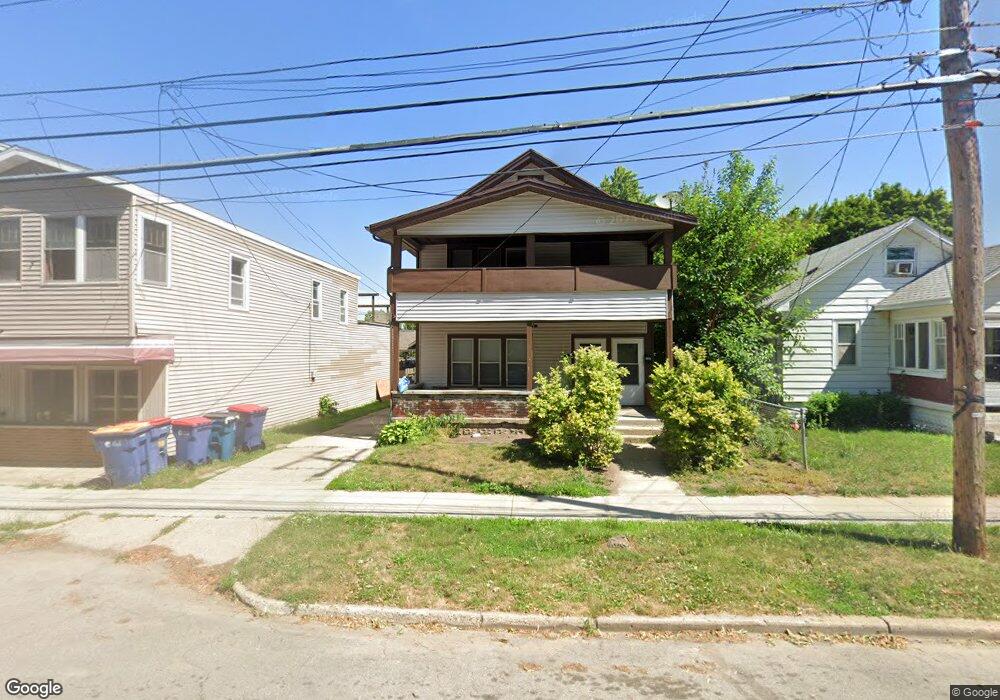
705 Knapp St NE Grand Rapids, MI 49505
Creston NeighborhoodEstimated Value: $305,604 - $354,000
3
Beds
1
Bath
--
Sq Ft
4,443
Sq Ft Lot
About This Home
This home is located at 705 Knapp St NE, Grand Rapids, MI 49505 and is currently estimated at $327,151. 705 Knapp St NE is a home located in Kent County with nearby schools including Riverside Middle School, Union High School, and ISJ Academy.
Ownership History
Date
Name
Owned For
Owner Type
Purchase Details
Closed on
Jun 28, 1996
Bought by
Vanderark D and Dva Llc
Current Estimated Value
Purchase Details
Closed on
Jun 27, 1996
Sold by
Briggs Briggs C C and Briggs Vanderark D
Bought by
Vanderark D and Dva Llc
Purchase Details
Closed on
Jun 26, 1996
Sold by
Vnderark Vnderark D D and Vnderark Vnderrk D
Bought by
Vnderrk D and Dva Llc
Purchase Details
Closed on
Jun 25, 1996
Sold by
Harwood Harwood M M and Harwood Briggs C
Bought by
Briggs C and Dva Llc
Purchase Details
Closed on
Mar 29, 1995
Sold by
Briggs Briggs C C and Briggs Vanderark D
Bought by
Vanderark D and Dva Llc
Create a Home Valuation Report for This Property
The Home Valuation Report is an in-depth analysis detailing your home's value as well as a comparison with similar homes in the area
Home Values in the Area
Average Home Value in this Area
Purchase History
| Date | Buyer | Sale Price | Title Company |
|---|---|---|---|
| Vanderark D | $54,600 | -- | |
| Vanderark D | $54,600 | -- | |
| Vnderrk D | -- | -- | |
| Briggs C | $35,000 | -- | |
| Vanderark D | -- | -- |
Source: Public Records
Tax History Compared to Growth
Tax History
| Year | Tax Paid | Tax Assessment Tax Assessment Total Assessment is a certain percentage of the fair market value that is determined by local assessors to be the total taxable value of land and additions on the property. | Land | Improvement |
|---|---|---|---|---|
| 2025 | $2,562 | $147,300 | $0 | $0 |
| 2024 | $2,562 | $127,800 | $0 | $0 |
| 2023 | $2,541 | $111,400 | $0 | $0 |
| 2022 | $2,323 | $97,900 | $0 | $0 |
| 2021 | $2,353 | $89,600 | $0 | $0 |
| 2020 | $2,275 | $81,200 | $0 | $0 |
| 2019 | $2,329 | $69,400 | $0 | $0 |
| 2018 | $2,258 | $56,500 | $0 | $0 |
| 2017 | $2,202 | $47,300 | $0 | $0 |
| 2016 | $2,213 | $42,900 | $0 | $0 |
| 2015 | $2,109 | $42,900 | $0 | $0 |
| 2013 | -- | $45,100 | $0 | $0 |
Source: Public Records
Map
Nearby Homes
- 612 Woodridge St NE
- 2038 Melita Ave NE
- 738 Graceland St NE
- 2019 Plainfield Ave NE
- 778 Eleanor St NE
- 2030 Sinclair Ave NE
- 465 Kenwood St NE
- 1825 Meadowfield Dr NE
- 1757 Westlane Dr NE
- 1848 Emerald Ave NE
- 321 Knapp St NE
- 240 Eleanor St NE
- 861 Aberdeen St NE
- 1922 Coit Ave NE
- 2471 Union Ave NE
- 2155 Coit Ave NE
- 1824 Herrick Ave NE
- 143 Dean St NE
- 132 Graceland St NE
- 1119 Kentwood Dr NE
- 701 Knapp St NE
- 711 Knapp St NE
- 2012 Edgewood Ave NE
- 715 Knapp St NE
- 2018 Edgewood Ave NE
- 719 Knapp St NE
- 629 Knapp St NE
- 2013 Melita Ave NE
- 625 Knapp St NE
- 2017 Melita Ave NE
- 2009 Edgewood Ave NE
- 2017 Edgewood Ave NE
- 619 Knapp St NE
- 2023 Melita Ave NE
- 2028 Edgewood Ave NE
- 2021 Edgewood Ave NE
- 615 Knapp St NE
- 2029 Melita Ave NE
- 2034 Edgewood Ave NE
- 616 Woodridge St NE