Estimated Value: $284,000 - $355,450
Studio
--
Bath
1,361
Sq Ft
$233/Sq Ft
Est. Value
About This Home
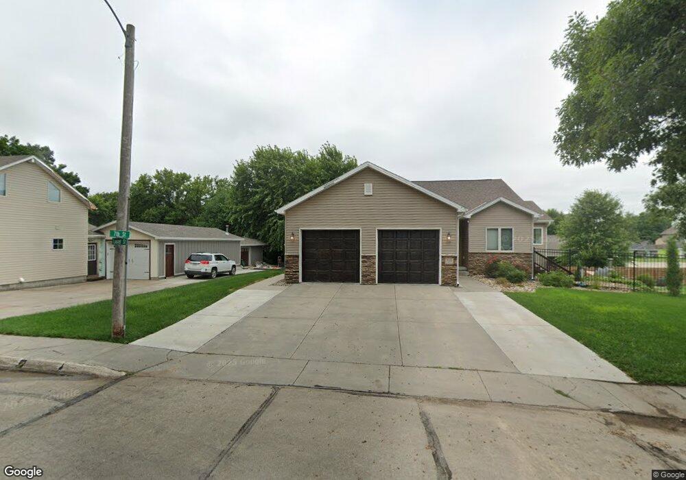
This home is located at 705 N Laurel St, Wahoo, NE 68066 and is currently estimated at $317,363, approximately $233 per square foot. 705 N Laurel St is a home located in Saunders County with nearby schools including Wahoo Elementary School, Wahoo Middle School, and Wahoo High School.
Ownership History
Date
Name
Owned For
Owner Type
Purchase Details
Closed on
Nov 14, 2018
Sold by
Darrell Robert and Cline Robert Darrell
Bought by
Cline Robert Darrell and Cline Kelly
Current Estimated Value
Purchase Details
Closed on
Nov 30, 2009
Sold by
Sutton Land Company Llc
Bought by
Cline Robert Darrell and Cline Sr. Robert Darrelle
Purchase Details
Closed on
Nov 25, 2009
Sold by
Sutton Land Company Llc
Bought by
Cline Robert Darrell and Cline Sr. Robert Darrelle
Create a Home Valuation Report for This Property
The Home Valuation Report is an in-depth analysis detailing your home's value as well as a comparison with similar homes in the area
Home Values in the Area
Average Home Value in this Area
Purchase History
| Date | Buyer | Sale Price | Title Company |
|---|---|---|---|
| Cline Robert Darrell | -- | None Available | |
| Cline Robert Darrell | -- | -- | |
| Cline Robert Darrell | -- | -- |
Source: Public Records
Mortgage History
| Date | Status | Borrower | Loan Amount |
|---|---|---|---|
| Previous Owner | Cline Robert Darrell | $139,000 |
Source: Public Records
Tax History
| Year | Tax Paid | Tax Assessment Tax Assessment Total Assessment is a certain percentage of the fair market value that is determined by local assessors to be the total taxable value of land and additions on the property. | Land | Improvement |
|---|---|---|---|---|
| 2025 | $4,239 | $314,377 | $37,203 | $277,174 |
| 2024 | $4,126 | $306,818 | $37,203 | $269,615 |
| 2023 | $5,370 | $306,818 | $37,203 | $269,615 |
| 2022 | $6,107 | $325,613 | $37,203 | $288,410 |
| 2021 | $4,221 | $218,938 | $37,203 | $181,735 |
| 2020 | $4,134 | $213,021 | $37,203 | $175,818 |
| 2019 | $4,052 | $204,170 | $37,200 | $166,970 |
| 2018 | $4,231 | $204,170 | $37,200 | $166,970 |
| 2017 | $4,219 | $204,170 | $37,200 | $166,970 |
| 2016 | $3,913 | $186,590 | $32,390 | $154,200 |
| 2015 | $3,941 | $186,590 | $32,390 | $154,200 |
| 2014 | $4,011 | $186,590 | $32,390 | $154,200 |
| 2012 | $4,245 | $186,590 | $32,390 | $154,200 |
Source: Public Records
Map
Nearby Homes
- 453 W 7th St
- 565 W 10th St
- 720 W 10th St
- 453 W 4th St
- 810 W 11th St
- 1175 N Locust St
- 1152 N Sycamore St
- 2125 N Broadway St
- 243 S Linden St
- 1530 N Linden St
- 1459 N Elm St
- 1989 N Linden St
- 454 E 15th St
- 478 E 15th St
- 26.26 Acres NW 19th & County Road Q
- Lot 3 Wanahoo Ridges
- 1502 Spruce St
- 731 W 24th Cir
- 778 W 24th Cir
- 1644 County Road 16
Your Personal Tour Guide
Ask me questions while you tour the home.