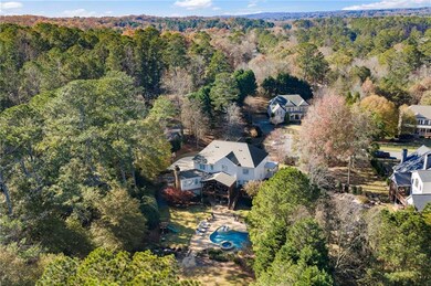

705 Nettlebrook Ln Alpharetta, GA 30004
Estimated payment $10,334/month
Highlights
- Media Room
- Pool and Spa
- View of Trees or Woods
- Birmingham Falls Elementary School Rated A
- Sitting Area In Primary Bedroom
- Wolf Appliances
About This Home
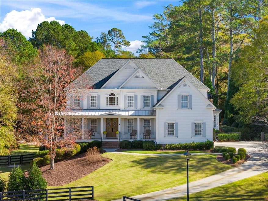
Set on a private cul de sac in the sought after swim/tennis community of Nettlebrook Farms, this beautifully updated Milton residence brings together classic curb appeal, curated interiors, and a true resort style outdoor experience. Hardiplank exterior, double front doors and newly added wrought iron railings introduce the home with quiet sophistication, while mature landscaping frames the entry and hints at the thoughtful updates found throughout.
Inside, a bright two story foyer opens to hardwood floors that continue throughout the main and upper levels including all bedrooms. Plantation shutters, updated lighting, and detailed trim work create a timeless backdrop for both everyday living and elegant entertaining. The formal spaces sit gracefully at the front of the home, while the layout naturally draws you into the heart of the house.
The renovated kitchen blends function and refined design with custom cabinetry, quartzite countertops and backsplash, a Sub Zero refrigerator, and a full suite of Wolf stainless steel appliances. Organized storage solutions elevate the cooking experience, and an additional ice maker at the bar enhances entertaining. A casual dining area overlooks the backyard and offers access to the expansive covered deck for easy indoor to outdoor flow. The nearby mudroom provides exceptional storage and keeps daily routines seamless.
The vaulted family room is warm and inviting with abundant natural light and views of the tree lined yard. Upstairs, the primary suite offers a peaceful retreat with a sitting area and a marble bathroom renovated in 2022. Heated floors, custom cabinetry, a soaking bathtub, a large walk-in closet and a beautifully designed shower create a spa inspired atmosphere. All additional full bathrooms on the main and upper levels were remodeled in marble for a cohesive and elevated aesthetic.
The terrace level has been thoughtfully transformed into a multifunctional extension of the home. A full bar with a dishwasher, microwave, full refrigerator and ice maker anchors a spacious living area with four television and speaker zones. A dedicated home theater, a gym with a steam shower, a secondary washer and dryer, custom barn doors, and generous workroom and storage areas complete this impressive level.
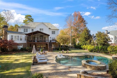
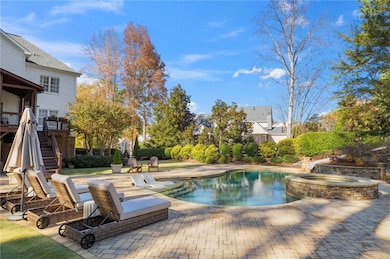
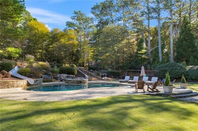
Outdoors, the property becomes an everyday escape. A sparkling pool with a slide and hot tub sits within more than two thousand two hundred square feet of pavers that create multiple lounging and entertaining areas. The covered deck and lower patio overlook extensive landscaping crafted for beauty and privacy. Three outdoor speaker zones, an automated mosquito system, full perimeter fencing, an invisible dog fence and a hidden storage area for toys and equipment add comfort and convenience. An expansive parking area accommodates teens, guests or gatherings with ease.
Additional upgrades include a roof replaced in 2018, replaced shutters, new double front doors, three Wi Fi enabled keycode entry systems, seven Ring cameras, updated HVAC systems including main and upper units replaced in 2024, and a septic system recently serviced with both pumps replaced.
Residents of Nettlebrook Farms enjoy an active swim and tennis community, and this location provides exceptional access to, Crabapple, downtown Alpharetta, Avalon and top ranked schools including Birmingham Falls Elementary, Hopewell Middle and Cambridge High. Welcome home!
Listing Agent
Atlanta Fine Homes Sotheby's International License #298200 Listed on: 11/15/2025

Home Details
Home Type
- Single Family
Est. Annual Taxes
- $8,917
Year Built
- Built in 2003
Lot Details
- 1.45 Acre Lot
- Irrigation Equipment
- Back Yard Fenced and Front Yard
HOA Fees
- $104 Monthly HOA Fees
Parking
- 3 Car Attached Garage
- Side Facing Garage
- Driveway
Property Views
- Woods
- Neighborhood
Home Design
- Traditional Architecture
- Brick Exterior Construction
- Composition Roof
- Concrete Perimeter Foundation
- HardiePlank Type
Interior Spaces
- 2-Story Property
- Home Theater Equipment
- Bookcases
- Crown Molding
- Coffered Ceiling
- Tray Ceiling
- Vaulted Ceiling
- Ceiling Fan
- Plantation Shutters
- Mud Room
- Living Room with Fireplace
- Formal Dining Room
- Media Room
- Home Office
- Bonus Room
- Workshop
- Screened Porch
- Keeping Room with Fireplace
- 2 Fireplaces
- Home Gym
- Wood Flooring
- Fire and Smoke Detector
Kitchen
- Eat-In Kitchen
- Breakfast Bar
- Double Oven
- Dishwasher
- Wolf Appliances
- Kitchen Island
- Stone Countertops
- Wood Stained Kitchen Cabinets
Bedrooms and Bathrooms
- Sitting Area In Primary Bedroom
- Walk-In Closet
- Vaulted Bathroom Ceilings
- Dual Vanity Sinks in Primary Bathroom
- Separate Shower in Primary Bathroom
- Soaking Tub
- Steam Shower
Laundry
- Laundry Room
- Laundry on upper level
- Dryer
- Washer
Finished Basement
- Walk-Out Basement
- Interior and Exterior Basement Entry
Pool
- Pool and Spa
- In Ground Pool
- Waterfall Pool Feature
Outdoor Features
- Deck
- Patio
- Exterior Lighting
Location
- Property is near schools
Schools
- Birmingham Falls Elementary School
- Hopewell Middle School
- Cambridge High School
Utilities
- Central Air
- Heating System Uses Natural Gas
- Underground Utilities
- Septic Tank
- Cable TV Available
Listing and Financial Details
- Assessor Parcel Number 22 459007451034
Community Details
Overview
- Nettlebrook Subdivision
- Rental Restrictions
Recreation
- Tennis Courts
- Community Playground
- Community Pool
Map
Home Values in the Area
Average Home Value in this Area
Tax History
| Year | Tax Paid | Tax Assessment Tax Assessment Total Assessment is a certain percentage of the fair market value that is determined by local assessors to be the total taxable value of land and additions on the property. | Land | Improvement |
|---|---|---|---|---|
| 2025 | $1,525 | $437,680 | $105,240 | $332,440 |
| 2023 | $12,496 | $442,720 | $105,240 | $337,480 |
| 2022 | $5,875 | $234,720 | $47,200 | $187,520 |
| 2021 | $5,866 | $227,840 | $45,800 | $182,040 |
| 2020 | $7,735 | $290,160 | $54,720 | $235,440 |
| 2019 | $1,445 | $285,040 | $53,760 | $231,280 |
| 2018 | $7,514 | $278,320 | $52,480 | $225,840 |
| 2017 | $5,489 | $200,080 | $44,840 | $155,240 |
| 2016 | $5,488 | $200,080 | $44,840 | $155,240 |
| 2015 | $6,386 | $200,080 | $44,840 | $155,240 |
| 2014 | $5,350 | $187,280 | $42,240 | $145,040 |
Purchase History
| Date | Type | Sale Price | Title Company |
|---|---|---|---|
| Deed | $625,000 | -- | |
| Deed | $562,800 | -- |
Mortgage History
| Date | Status | Loan Amount | Loan Type |
|---|---|---|---|
| Open | $500,000 | New Conventional | |
| Previous Owner | $450,190 | New Conventional |
Source: First Multiple Listing Service (FMLS)
MLS Number: 7679243
APN: 22-4590-0745-103-4
Disclaimer: Certain information contained herein is derived from information provided by parties other than Homes.com. All information provided is deemed reliable, but is not guaranteed to be accurate and should be independently verified.
![]() Listings identified with the FMLS IDX logo come from FMLS and are held by brokerage firms other than the owner of this website. The listing brokerage is identified in any listing details. Information is deemed reliable but is not guaranteed. If you believe any FMLS listing contains material that infringes your copyrighted work please visit www.fmls.com/dmca to review our DMCA policy and learn how to submit a takedown request. © 2025 First Multiple Listing Service, Inc.
Listings identified with the FMLS IDX logo come from FMLS and are held by brokerage firms other than the owner of this website. The listing brokerage is identified in any listing details. Information is deemed reliable but is not guaranteed. If you believe any FMLS listing contains material that infringes your copyrighted work please visit www.fmls.com/dmca to review our DMCA policy and learn how to submit a takedown request. © 2025 First Multiple Listing Service, Inc.
- 1530 Redd Rd
- 14200 Hopewell Rd
- 139200 Cowart Rd
- 14250 Freemanville Rd
- 14260 Phillips Cir
- Lot 2 Cowart Rd
- LOT 2 13920 Cowart Rd
- 13890 Cowart Rd
- 13825 Cowart Rd
- 14050 Providence Rd
- 735 Hammock Ln
- 520 N Burgess Trail
- 14040 Providence Rd
- 1425 Rolling Links Dr
- 360 Wigton Dr
- 2337 Bethany Bend
- 490 N Fields Pass
- 14300 Providence Rd
- 14560 Wood Rd
- 0 State Highway 9 Hwy Unit 10257856
- 14895 Freemanville Rd
- 15485 N Valley Creek Ln
- 2385 Hopewell Plantation Dr
- 1880 Heritage Walk Unit O201
- 15448 Hopewell Rd
- 1145 Mayfield Rd
- 940 Southfield Ln
- 2440 Lunetta Ln
- 146 Brindle Ln
- 13310 Marrywood Dr
- 1088 Colony Dr
- 2875 Webb Rd
- 3567 Archgate Ct
- 3587 Archgate Ct
- 2012 Cortland Rd
- 3842 Avensong Village Cir
- 15905 Westbrook Rd
- 13201 Deerfield Pkwy
- 820 Camelon Ct
- 1070 Poppy Pointe