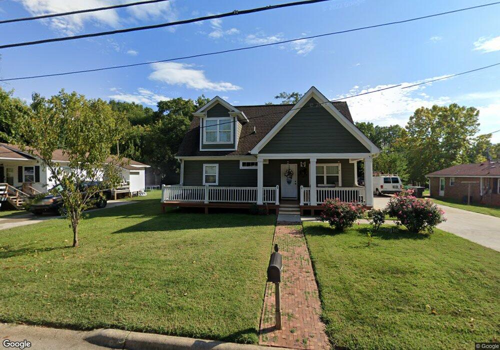
705 Redding Dr High Point, NC 27260
Greater High Point NeighborhoodEstimated Value: $172,000 - $277,000
4
Beds
3
Baths
1,872
Sq Ft
$117/Sq Ft
Est. Value
About This Home
This home is located at 705 Redding Dr, High Point, NC 27260 and is currently estimated at $218,547, approximately $116 per square foot. 705 Redding Dr is a home located in Guilford County with nearby schools including Fairview Elementary School, Ferndale Middle School, and High Point Central High School.
Ownership History
Date
Name
Owned For
Owner Type
Purchase Details
Closed on
Mar 14, 2014
Sold by
Mosqueda Martin and Rapmirez Jose Lionso
Bought by
Ortiz Efren Martinez and Aguilar Sagrario Galvan
Current Estimated Value
Purchase Details
Closed on
Sep 29, 2011
Sold by
U S Bank National Association
Bought by
Mosqueda Martin and Ramirez Jose Lionso
Purchase Details
Closed on
Jul 26, 2011
Sold by
Agapion Basil Nt
Bought by
Us Bank National Association
Purchase Details
Closed on
Sep 5, 2002
Sold by
Patterson Tony Lloyd and Manning Hattie Mae Patterson Womack
Bought by
Agapion Basil N T
Purchase Details
Closed on
May 21, 1999
Sold by
Waynick Howard S and Waynick Inez Payne
Bought by
Parker Herman R and Parker Brenda Y
Create a Home Valuation Report for This Property
The Home Valuation Report is an in-depth analysis detailing your home's value as well as a comparison with similar homes in the area
Home Values in the Area
Average Home Value in this Area
Purchase History
| Date | Buyer | Sale Price | Title Company |
|---|---|---|---|
| Ortiz Efren Martinez | $30,000 | Attorney | |
| Mosqueda Martin | $9,000 | None Available | |
| Us Bank National Association | $39,000 | None Available | |
| Agapion Basil N T | $40,635 | -- | |
| Parker Herman R | $48,500 | -- |
Source: Public Records
Tax History
| Year | Tax Paid | Tax Assessment Tax Assessment Total Assessment is a certain percentage of the fair market value that is determined by local assessors to be the total taxable value of land and additions on the property. | Land | Improvement |
|---|---|---|---|---|
| 2025 | $1,809 | $131,300 | $9,000 | $122,300 |
| 2024 | $1,809 | $131,300 | $9,000 | $122,300 |
| 2023 | $1,809 | $131,300 | $9,000 | $122,300 |
| 2022 | $1,770 | $131,300 | $9,000 | $122,300 |
| 2021 | $1,487 | $107,900 | $10,000 | $97,900 |
| 2020 | $1,487 | $107,900 | $10,000 | $97,900 |
| 2019 | $1,487 | $107,900 | $0 | $0 |
| 2018 | $1,479 | $107,900 | $0 | $0 |
| 2017 | $1,426 | $107,900 | $0 | $0 |
| 2016 | $1,063 | $75,800 | $0 | $0 |
| 2015 | $1,069 | $75,800 | $0 | $0 |
| 2014 | $1,087 | $75,800 | $0 | $0 |
Source: Public Records
Map
Nearby Homes
- 527 Amos St
- 525 Amos St
- 609 Cross St
- 703 Langford Ave
- 608 Vail Ave
- 812 Tryon Ave
- 816 Tryon Ave
- 328 Ennis St
- 711 Fairview St
- 405 W Willis Ave
- 616 S Elm St
- 112 Briggs Place Unit A & B
- 537 Flint Ave
- 604 W Ward Ave
- 308 W Kearns Ave
- 403 Phillips Ave
- 1213 S Elm St
- 1217 Cloverdale St
- 1307 Tipton St
- 323 Coltrane Ave
Your Personal Tour Guide
Ask me questions while you tour the home.