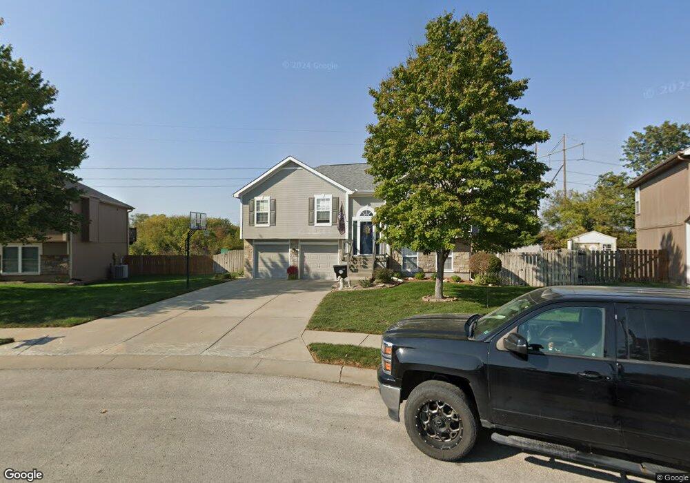
705 Terry Dr Pleasant Hill, MO 64080
Estimated Value: $299,000 - $327,000
3
Beds
2
Baths
1,246
Sq Ft
$252/Sq Ft
Est. Value
About This Home
This home is located at 705 Terry Dr, Pleasant Hill, MO 64080 and is currently estimated at $313,775, approximately $251 per square foot. 705 Terry Dr is a home located in Cass County with nearby schools including Pleasant Hill Primary School, Pleasant Hill Elementary School, and Pleasant Hill Intermediate School.
Ownership History
Date
Name
Owned For
Owner Type
Purchase Details
Closed on
Nov 20, 2020
Sold by
Merz Jeremy D and Merz Nicole Kay
Bought by
Merz Jeremy Douglas and Merz Nicole Kay
Current Estimated Value
Home Financials for this Owner
Home Financials are based on the most recent Mortgage that was taken out on this home.
Original Mortgage
$164,000
Outstanding Balance
$117,618
Interest Rate
2.8%
Mortgage Type
New Conventional
Estimated Equity
$196,157
Purchase Details
Closed on
Jan 30, 2008
Sold by
M Y Homes Llc
Bought by
Merz Jeremy D
Home Financials for this Owner
Home Financials are based on the most recent Mortgage that was taken out on this home.
Original Mortgage
$148,400
Interest Rate
6.15%
Mortgage Type
New Conventional
Create a Home Valuation Report for This Property
The Home Valuation Report is an in-depth analysis detailing your home's value as well as a comparison with similar homes in the area
Home Values in the Area
Average Home Value in this Area
Purchase History
| Date | Buyer | Sale Price | Title Company |
|---|---|---|---|
| Merz Jeremy Douglas | -- | None Available | |
| Merz Jeremy D | -- | -- |
Source: Public Records
Mortgage History
| Date | Status | Borrower | Loan Amount |
|---|---|---|---|
| Open | Merz Jeremy Douglas | $164,000 | |
| Closed | Merz Jeremy D | $148,400 |
Source: Public Records
Tax History
| Year | Tax Paid | Tax Assessment Tax Assessment Total Assessment is a certain percentage of the fair market value that is determined by local assessors to be the total taxable value of land and additions on the property. | Land | Improvement |
|---|---|---|---|---|
| 2025 | $2,722 | $42,720 | $5,350 | $37,370 |
| 2024 | $2,722 | $37,740 | $4,860 | $32,880 |
| 2023 | $2,702 | $37,740 | $4,860 | $32,880 |
| 2022 | $2,456 | $33,660 | $4,860 | $28,800 |
| 2021 | $2,388 | $33,660 | $4,860 | $28,800 |
| 2020 | $2,306 | $33,280 | $4,860 | $28,420 |
| 2019 | $2,275 | $33,280 | $4,860 | $28,420 |
| 2018 | $2,074 | $29,940 | $4,170 | $25,770 |
| 2017 | $1,976 | $29,940 | $4,170 | $25,770 |
| 2016 | $1,976 | $28,400 | $4,170 | $24,230 |
| 2015 | $2,001 | $28,400 | $4,170 | $24,230 |
| 2014 | $2,009 | $28,400 | $4,170 | $24,230 |
| 2013 | -- | $28,400 | $4,170 | $24,230 |
Source: Public Records
Map
Nearby Homes
- 1012 SW State Route 7
- 2304 Valley View W
- 604 Canyon Dr
- 2009 Ridge Tree Dr
- 1900 Hidden Valley Dr
- 809 Colonial Dr
- 1907 Owen Dr
- 1903 Owen Dr
- 1405 E State Route Vv
- 1901 Owen Dr
- 1202 Morgan Dr
- 807 Old Stage Rd
- 1411 Whispering Ridge
- 0 Lexington Rd
- 1309 Russell Rd
- 1009 N Independence St
- 30310 Woodland Dr
- 914 Riffle Dr
- 902 Highland St
- 1201 Maple Ln
Your Personal Tour Guide
Ask me questions while you tour the home.