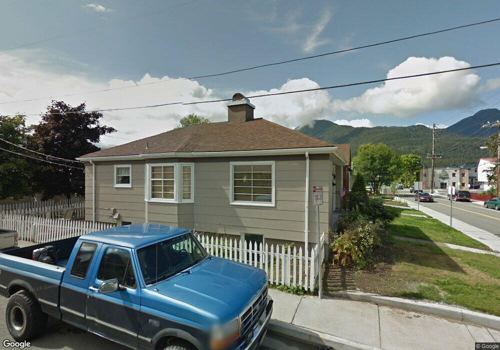
705 W 12th St Juneau, AK 99801
Downtown Juneau NeighborhoodEstimated Value: $359,000 - $601,000
3
Beds
2
Baths
855
Sq Ft
$589/Sq Ft
Est. Value
About This Home
This home is located at 705 W 12th St, Juneau, AK 99801 and is currently estimated at $503,718, approximately $589 per square foot. 705 W 12th St is a home located in Juneau City and Borough with nearby schools including Harborview Elementary School, Dzantik'i Heeni Middle School, and Juneau Community Charter School.
Ownership History
Date
Name
Owned For
Owner Type
Purchase Details
Closed on
Aug 9, 2022
Sold by
Gladhart Rachel C and Gladhart Andrew W
Bought by
Dunn Sarah E and Lucas Boykin D
Current Estimated Value
Home Financials for this Owner
Home Financials are based on the most recent Mortgage that was taken out on this home.
Original Mortgage
$300,000
Outstanding Balance
$286,815
Interest Rate
5.51%
Mortgage Type
New Conventional
Estimated Equity
$216,903
Purchase Details
Closed on
Nov 14, 2016
Sold by
Gladhart Rachel
Bought by
Gladhart Rachel C and Baird Andrew W
Home Financials for this Owner
Home Financials are based on the most recent Mortgage that was taken out on this home.
Original Mortgage
$125,000
Interest Rate
3.47%
Mortgage Type
Commercial
Purchase Details
Closed on
Jun 30, 2010
Sold by
Eyrikson Kristopher J
Bought by
Gladhart Rachel
Home Financials for this Owner
Home Financials are based on the most recent Mortgage that was taken out on this home.
Original Mortgage
$292,066
Interest Rate
4.82%
Mortgage Type
FHA
Purchase Details
Closed on
Sep 28, 2009
Sold by
Lombardo Theresa
Bought by
Eyrikson Kristopher J
Home Financials for this Owner
Home Financials are based on the most recent Mortgage that was taken out on this home.
Original Mortgage
$290,638
Interest Rate
5.14%
Mortgage Type
FHA
Purchase Details
Closed on
Dec 5, 2005
Sold by
Lombardo Theresa and Tanoury Theresa M
Bought by
Lombardo Theresa
Home Financials for this Owner
Home Financials are based on the most recent Mortgage that was taken out on this home.
Original Mortgage
$222,780
Interest Rate
6.31%
Mortgage Type
Commercial
Purchase Details
Closed on
Oct 30, 2001
Sold by
Osborne Elsie G
Bought by
Tanoury Theresa M
Home Financials for this Owner
Home Financials are based on the most recent Mortgage that was taken out on this home.
Original Mortgage
$144,000
Interest Rate
6.84%
Mortgage Type
Commercial
Create a Home Valuation Report for This Property
The Home Valuation Report is an in-depth analysis detailing your home's value as well as a comparison with similar homes in the area
Home Values in the Area
Average Home Value in this Area
Purchase History
| Date | Buyer | Sale Price | Title Company |
|---|---|---|---|
| Dunn Sarah E | -- | First American Title | |
| Gladhart Rachel C | -- | Aetia | |
| Gladhart Rachel | -- | Aetia | |
| Eyrikson Kristopher J | -- | Title Insurance Agency | |
| Lombardo Theresa | -- | None Available | |
| Tanoury Theresa M | -- | Title Insurance Agency |
Source: Public Records
Mortgage History
| Date | Status | Borrower | Loan Amount |
|---|---|---|---|
| Open | Dunn Sarah E | $300,000 | |
| Previous Owner | Gladhart Rachel C | $125,000 | |
| Previous Owner | Gladhart Rachel | $292,066 | |
| Previous Owner | Eyrikson Kristopher J | $290,638 | |
| Previous Owner | Lombardo Theresa | $222,780 | |
| Previous Owner | Tanoury Theresa M | $144,000 | |
| Closed | Tanoury Theresa M | $27,000 |
Source: Public Records
Tax History Compared to Growth
Tax History
| Year | Tax Paid | Tax Assessment Tax Assessment Total Assessment is a certain percentage of the fair market value that is determined by local assessors to be the total taxable value of land and additions on the property. | Land | Improvement |
|---|---|---|---|---|
| 2025 | $5,110 | $499,000 | $187,300 | $311,700 |
| 2024 | $4,804 | $478,500 | $187,300 | $291,200 |
| 2023 | $4,758 | $468,300 | $187,300 | $281,000 |
| 2022 | $4,550 | $430,900 | $170,100 | $260,800 |
| 2021 | $4,024 | $381,100 | $170,100 | $211,000 |
| 2020 | $3,999 | $375,100 | $170,100 | $205,000 |
| 2019 | $4,220 | $395,828 | $151,801 | $244,027 |
| 2018 | $3,920 | $395,828 | $151,801 | $244,027 |
| 2017 | $3,920 | $382,443 | $146,668 | $235,775 |
| 2016 | $3,920 | $367,734 | $141,027 | $226,707 |
| 2015 | -- | $340,495 | $130,581 | $209,914 |
| 2014 | -- | $324,900 | $124,600 | $200,300 |
Source: Public Records
Map
Nearby Homes
- 275 Irwin St
- 3030 Foster Ave
- 3185 Pioneer Ave
- 0 Pioneer Ave
- 356 S Franklin St
- 2950 Simpson Ave
- 2753 John St
- 2751 David St
- 2718 Roger St
- 0 Merritt Rd
- NHN Vista Dr
- 2551 Vista Dr Unit 102-C
- 1853 Bartlett Ave
- 2213 Raven Rd Unit D
- 2031 Glacier Hwy
- 2196 Lawson Creek Rd Unit D
- 2196 Lawson Creek Rd
- 2185 Crow Hill Dr
- 6205 N Douglas Hwy
- 6260 N Douglas Hwy