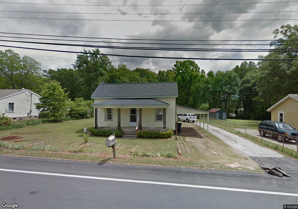
705 W Curtis St Simpsonville, SC 29681
Estimated Value: $106,000 - $189,000
2
Beds
1
Bath
792
Sq Ft
$191/Sq Ft
Est. Value
About This Home
This home is located at 705 W Curtis St, Simpsonville, SC 29681 and is currently estimated at $151,426, approximately $191 per square foot. 705 W Curtis St is a home located in Greenville County with nearby schools including Simpsonville Elementary, Hillcrest Middle School, and Hillcrest High School.
Ownership History
Date
Name
Owned For
Owner Type
Purchase Details
Closed on
May 12, 2025
Sold by
Winch Donald L and Winch Karen K
Bought by
Winch Donald L and Winch Karen K
Current Estimated Value
Purchase Details
Closed on
Apr 5, 2012
Sold by
Beth Haven Baptist Church
Bought by
Winch Donald L and Winch Karen K
Home Financials for this Owner
Home Financials are based on the most recent Mortgage that was taken out on this home.
Original Mortgage
$40,000
Interest Rate
3.97%
Mortgage Type
Purchase Money Mortgage
Purchase Details
Closed on
Jan 24, 2003
Sold by
Pressley Charles E
Bought by
Pressley Charles E
Create a Home Valuation Report for This Property
The Home Valuation Report is an in-depth analysis detailing your home's value as well as a comparison with similar homes in the area
Home Values in the Area
Average Home Value in this Area
Purchase History
| Date | Buyer | Sale Price | Title Company |
|---|---|---|---|
| Winch Donald L | -- | None Listed On Document | |
| Winch Donald L | -- | None Listed On Document | |
| Winch Donald L | $39,000 | -- | |
| Pressley Charles E | -- | -- |
Source: Public Records
Mortgage History
| Date | Status | Borrower | Loan Amount |
|---|---|---|---|
| Previous Owner | Winch Donald L | $40,000 |
Source: Public Records
Tax History Compared to Growth
Tax History
| Year | Tax Paid | Tax Assessment Tax Assessment Total Assessment is a certain percentage of the fair market value that is determined by local assessors to be the total taxable value of land and additions on the property. | Land | Improvement |
|---|---|---|---|---|
| 2024 | $190 | $1,760 | $560 | $1,200 |
| 2023 | $190 | $1,760 | $560 | $1,200 |
| 2022 | $190 | $1,760 | $560 | $1,200 |
| 2021 | $190 | $1,760 | $560 | $1,200 |
| 2020 | $205 | $1,530 | $320 | $1,210 |
| 2019 | $205 | $1,530 | $320 | $1,210 |
| 2018 | $72 | $1,530 | $320 | $1,210 |
| 2017 | $72 | $1,530 | $320 | $1,210 |
| 2016 | $47 | $38,360 | $8,000 | $30,360 |
| 2015 | $47 | $38,360 | $8,000 | $30,360 |
| 2014 | $786 | $39,690 | $8,319 | $31,371 |
Source: Public Records
Map
Nearby Homes
- 101 Iselin St
- 3990 Grandview Dr
- 3989 Grandview Dr
- 300 South St Unit 224
- 410 Richardson St Unit H
- 213 W Trade St
- 117 Sylvan Oak Way
- 112 Winespring Place
- 405 Jones Ave
- 113 Market Bay Ct
- 108 Anglewood Dr
- 00 W Georgia Rd
- 113 Anglewood Dr
- 101 Menlo Dr
- 209 Winespring Place
- 0 W Georgia Rd
- 305 N Maple St
- 308 Capewood Rd
- 303 Boyd Ave
- 114 Delmar Dr
- 707 W Curtis St
- 703 W Curtis St
- 709 W Curtis St
- 709 W Curtis St
- 711 W Curtis St
- 702 W Curtis St
- 714 W Curtis St
- 616 Goldburn Way
- 612 Cox St
- 624 Cox St
- 626 Cox St
- 630 Cox St
- 509 W Curtis St
- 27 Sidney Wilson Ct
- 632 Cox St
- 104 Woodside Park Dr
- 210 Iselin St
- 510 W Curtis St
- 32 Sidney Wilson Ct
- 608 Cox St