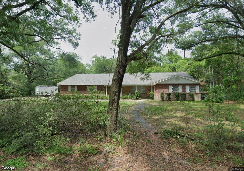
705 Yale Rd Deland, FL 32724
Estimated Value: $402,585 - $465,000
4
Beds
3
Baths
2,732
Sq Ft
$157/Sq Ft
Est. Value
About This Home
This home is located at 705 Yale Rd, Deland, FL 32724 and is currently estimated at $428,646, approximately $156 per square foot. 705 Yale Rd is a home located in Volusia County with nearby schools including Freedom Elementary School, Deland High School, and Deland Middle School.
Ownership History
Date
Name
Owned For
Owner Type
Purchase Details
Closed on
Dec 17, 2019
Sold by
Partain James Steven
Bought by
Ralon Lisa Ann Partain and Gratz Linda Marie Partain
Current Estimated Value
Purchase Details
Closed on
Mar 15, 2016
Sold by
Partain James Steven and Partain Nancy
Bought by
Kennedy Audrey
Purchase Details
Closed on
Mar 13, 2003
Sold by
Cousins Nancy and Brandt Catherine
Bought by
Partain J Steven and Partain Nancy M
Purchase Details
Closed on
Dec 15, 1971
Bought by
Partain James Steven
Create a Home Valuation Report for This Property
The Home Valuation Report is an in-depth analysis detailing your home's value as well as a comparison with similar homes in the area
Home Values in the Area
Average Home Value in this Area
Purchase History
| Date | Buyer | Sale Price | Title Company |
|---|---|---|---|
| Ralon Lisa Ann Partain | -- | Attorney | |
| Partain James Steven | -- | Attorney | |
| Kennedy Audrey | -- | None Available | |
| Partain J Steven | $152,000 | -- | |
| Partain James Steven | $5,300 | -- |
Source: Public Records
Tax History Compared to Growth
Tax History
| Year | Tax Paid | Tax Assessment Tax Assessment Total Assessment is a certain percentage of the fair market value that is determined by local assessors to be the total taxable value of land and additions on the property. | Land | Improvement |
|---|---|---|---|---|
| 2025 | $862 | $80,312 | -- | -- |
| 2024 | $862 | $78,049 | -- | -- |
| 2023 | $862 | $75,776 | $0 | $0 |
| 2022 | $910 | $73,569 | $0 | $0 |
| 2021 | $941 | $71,426 | $0 | $0 |
| 2020 | $932 | $70,440 | $0 | $0 |
| 2019 | $959 | $68,856 | $0 | $0 |
| 2018 | $952 | $67,572 | $0 | $0 |
| 2017 | $940 | $66,182 | $0 | $0 |
| 2016 | $906 | $64,821 | $0 | $0 |
| 2015 | $935 | $64,370 | $0 | $0 |
| 2014 | $932 | $63,859 | $0 | $0 |
Source: Public Records
Map
Nearby Homes
- 810 E Yorkshire Dr
- 2032 Yorkshire Dr
- 2337 Oxmoor Dr
- 2438 Dartmouth Rd
- 2094 Penn Dr
- 2368 Oxmoor Dr
- 2401 Oxmoor Dr
- 204 Wellington Woods Ave
- 2412 Regency Park Dr
- 929 Torchwood Dr
- 218 Wellington Woods Ave
- 511 Baroness Way
- 2400 S Glen Eagles Dr
- 2450 S Glen Eagles Dr
- 257 Huntington Dr
- 889 Torchwood Dr
- 2480 S Glen Eagles Dr
- 316 Nowell Loop
- 201 Dyson Dr
- 860 Torchwood Dr