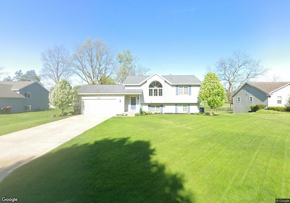
7053 Rolling Hills Dr Hudsonville, MI 49426
Estimated Value: $350,000 - $410,000
4
Beds
2
Baths
1,942
Sq Ft
$191/Sq Ft
Est. Value
About This Home
This home is located at 7053 Rolling Hills Dr, Hudsonville, MI 49426 and is currently estimated at $370,143, approximately $190 per square foot. 7053 Rolling Hills Dr is a home located in Ottawa County with nearby schools including Baldwin Street Middle School, Hudsonville Freshman Campus, and Hudsonville High School.
Ownership History
Date
Name
Owned For
Owner Type
Purchase Details
Closed on
Apr 23, 2004
Sold by
Stam Jeff and Stam Denise
Bought by
Vincent Craig R and Vincent Andrea
Current Estimated Value
Home Financials for this Owner
Home Financials are based on the most recent Mortgage that was taken out on this home.
Original Mortgage
$152,000
Outstanding Balance
$67,567
Interest Rate
4.87%
Mortgage Type
Purchase Money Mortgage
Estimated Equity
$302,576
Create a Home Valuation Report for This Property
The Home Valuation Report is an in-depth analysis detailing your home's value as well as a comparison with similar homes in the area
Home Values in the Area
Average Home Value in this Area
Purchase History
| Date | Buyer | Sale Price | Title Company |
|---|---|---|---|
| Vincent Craig R | $160,000 | Metropolitan Title Company |
Source: Public Records
Mortgage History
| Date | Status | Borrower | Loan Amount |
|---|---|---|---|
| Open | Vincent Craig R | $152,000 |
Source: Public Records
Tax History Compared to Growth
Tax History
| Year | Tax Paid | Tax Assessment Tax Assessment Total Assessment is a certain percentage of the fair market value that is determined by local assessors to be the total taxable value of land and additions on the property. | Land | Improvement |
|---|---|---|---|---|
| 2025 | $2,342 | $138,400 | $0 | $0 |
| 2024 | $2,026 | $129,000 | $0 | $0 |
| 2023 | $1,935 | $122,600 | $0 | $0 |
| 2022 | $2,127 | $109,400 | $0 | $0 |
| 2021 | $2,066 | $104,700 | $0 | $0 |
| 2020 | $2,045 | $95,800 | $0 | $0 |
| 2019 | $2,048 | $92,900 | $0 | $0 |
| 2018 | $1,891 | $88,800 | $0 | $0 |
| 2017 | $1,857 | $88,300 | $0 | $0 |
| 2016 | $1,752 | $76,800 | $0 | $0 |
| 2015 | $1,672 | $73,700 | $0 | $0 |
| 2014 | $1,672 | $65,600 | $0 | $0 |
Source: Public Records
Map
Nearby Homes
- 2921 N Wentward Ct
- 7313 Valhalla Dr
- 6760 N Wentward Ct
- 7381 Rolling Hills Dr
- 6714 Cedar Grove W
- 2698 Cedargrove N
- 6724 28th Ave
- 3528 Tearose Dr
- V/L Port Sheldon St
- 3204 Port Sheldon St
- 3544 Nobb Hill Dr
- 3617 Teton Dr
- 2323 Rosewood St
- 2682 Thrush Dr
- 6340 Summer Dr
- 2934 Parkside Dr Unit 54
- 2194 Oak Hollow Dr
- 7490 N Garden Ct
- 7342 Cherry Ave
- 7502 22nd Ave
- 7067 Rolling Hills Dr
- 7081 Rolling Hills Dr
- 7056 Rolling Hills Dr
- 7042 Rolling Hills Dr
- 3019 Rosewood St
- 7070 Rolling Hills Dr
- 3035 Rosewood St
- 7028 Rolling Hills Dr
- 3051 Rosewood St
- 7095 Rolling Hills Dr
- 7084 Rolling Hills Dr
- 7012 Rolling Hills Dr
- 7053 Michael Dr
- 7067 Michael Dr
- 7100 Rolling Hills Dr
- 6998 Vintage Dr
- 7109 Rolling Hills Dr
- 7081 Michael Dr
- 7045 Michael Dr
- 3069 Rosewood St