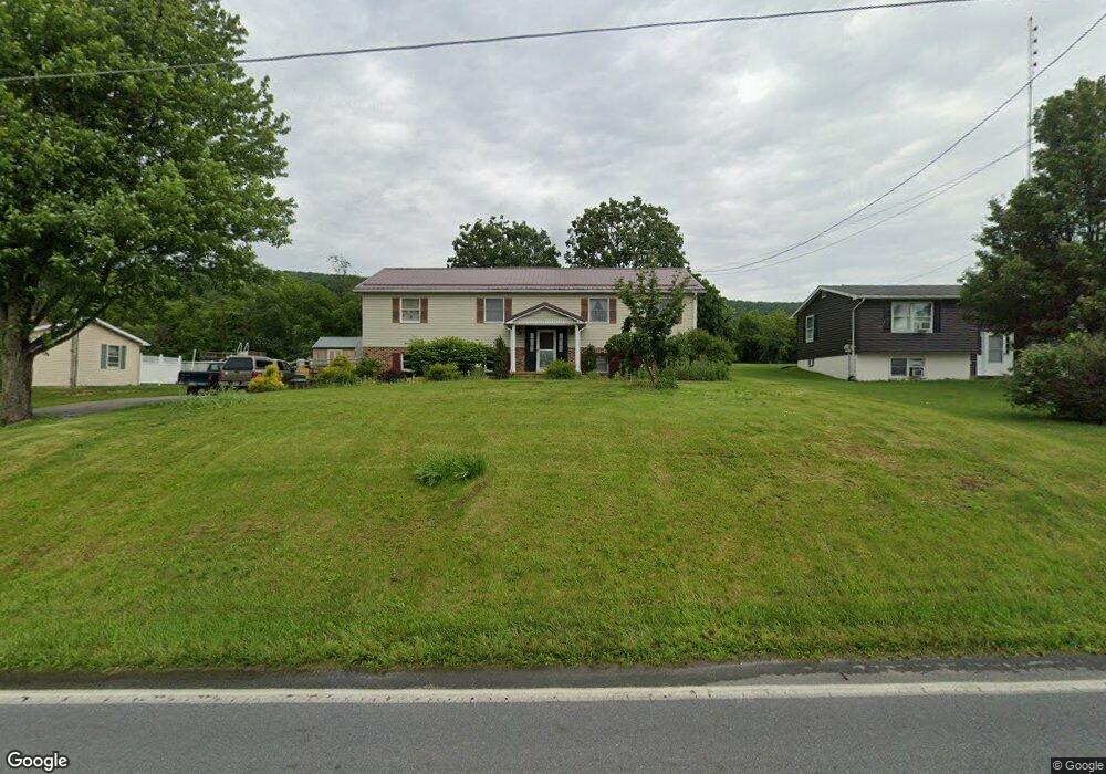
7054 Slabtown Rd Waynesboro, PA 17268
Estimated Value: $103,588 - $382,000
--
Bed
--
Bath
2,268
Sq Ft
$122/Sq Ft
Est. Value
About This Home
This home is located at 7054 Slabtown Rd, Waynesboro, PA 17268 and is currently estimated at $276,897, approximately $122 per square foot. 7054 Slabtown Rd is a home located in Franklin County with nearby schools including Waynesboro Area Senior High School and Providence School - Pigeon Hill Building.
Ownership History
Date
Name
Owned For
Owner Type
Purchase Details
Closed on
Nov 3, 2023
Sold by
Gilford Robert K and Gilford Gail M
Bought by
Gilford Robert K
Current Estimated Value
Purchase Details
Closed on
Apr 12, 2005
Sold by
Frazier Steven R and Frazier Mary A
Bought by
Gilford Robert K and Gilford Gail M
Home Financials for this Owner
Home Financials are based on the most recent Mortgage that was taken out on this home.
Original Mortgage
$179,900
Interest Rate
5.78%
Mortgage Type
Purchase Money Mortgage
Create a Home Valuation Report for This Property
The Home Valuation Report is an in-depth analysis detailing your home's value as well as a comparison with similar homes in the area
Home Values in the Area
Average Home Value in this Area
Purchase History
| Date | Buyer | Sale Price | Title Company |
|---|---|---|---|
| Gilford Robert K | -- | Buchanan Settlement Services | |
| Gilford Robert K | $189,900 | None Available |
Source: Public Records
Mortgage History
| Date | Status | Borrower | Loan Amount |
|---|---|---|---|
| Previous Owner | Gilford Robert K | $179,900 |
Source: Public Records
Tax History Compared to Growth
Tax History
| Year | Tax Paid | Tax Assessment Tax Assessment Total Assessment is a certain percentage of the fair market value that is determined by local assessors to be the total taxable value of land and additions on the property. | Land | Improvement |
|---|---|---|---|---|
| 2025 | $3,394 | $23,260 | $1,120 | $22,140 |
| 2024 | $3,289 | $23,260 | $1,120 | $22,140 |
| 2023 | $3,060 | $22,250 | $1,120 | $21,130 |
| 2022 | $2,971 | $22,250 | $1,120 | $21,130 |
| 2021 | $2,882 | $22,250 | $1,120 | $21,130 |
| 2020 | $2,882 | $22,250 | $1,120 | $21,130 |
| 2019 | $2,815 | $22,250 | $1,120 | $21,130 |
| 2018 | $2,720 | $22,250 | $1,120 | $21,130 |
| 2017 | $2,659 | $22,250 | $1,120 | $21,130 |
| 2016 | $637 | $22,250 | $1,120 | $21,130 |
| 2015 | $594 | $22,250 | $1,120 | $21,130 |
| 2014 | $594 | $22,250 | $1,120 | $21,130 |
Source: Public Records
Map
Nearby Homes
- 111 Poplar St
- 286 Verdier St
- 6 S Main St
- 7468 Anthony Hwy
- 7130 St Annes Dr
- 8620 Monns Gap Rd
- 7059 Duck Hook Ln
- 7060 Duck Hook Ln
- 7136 Sandwich Ln
- 7121 Sandwich Ln
- 7205 Fairway Dr S
- 6852 Lytham Ln
- 7023 Saint Annes Dr
- 6158 Merion Dr
- 5434 Manheim Rd
- 6337 Medina Ridge Dr
- 6396 Saucon Valley Dr
- 8652 Mormon Church Rd
- 7010 Fairway Oaks
- 7049 Killarney Dr
- 7044 Slabtown Rd
- 7062 Slabtown Rd
- 7032 Slabtown Rd
- 7090 Slabtown Rd
- 7000 Slabtown Rd
- 7100 Slabtown Rd
- 7106 Slabtown Rd
- 6984 Slabtown Rd
- 7096 Slabtown Rd
- 7116 Slabtown Rd
- 6565 Furnace Rd
- 7117 Slabtown Rd
- 6976 Slabtown Rd
- 7122 Slabtown Rd
- 6685 Furnace Rd
- 6962 Slabtown Rd
- 7132 Slabtown Rd
- 6908 Slabtown Rd
- 6960 Slabtown Rd
- 6585 Furnace Rd