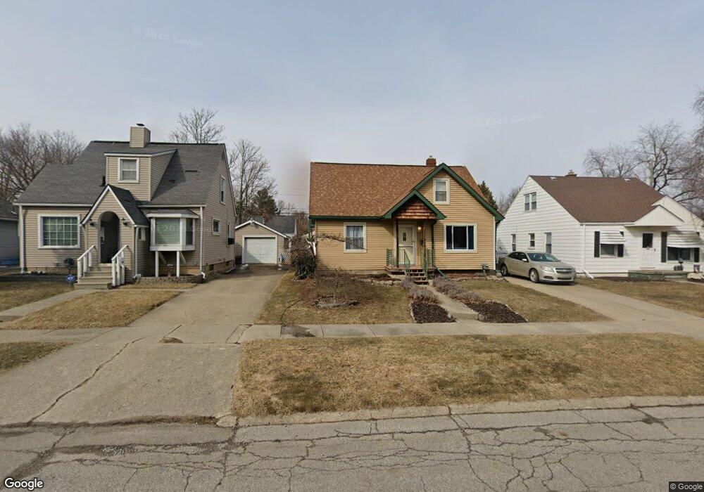
706 Alvord Ave Flint, MI 48507
South Side NeighborhoodEstimated Value: $73,849 - $99,000
--
Bed
1
Bath
1,016
Sq Ft
$82/Sq Ft
Est. Value
About This Home
This home is located at 706 Alvord Ave, Flint, MI 48507 and is currently estimated at $82,962, approximately $81 per square foot. 706 Alvord Ave is a home located in Genesee County with nearby schools including Neithercut Elementary School, Flint Southwestern Classical Academy, and International Academy of Flint (K-12).
Ownership History
Date
Name
Owned For
Owner Type
Purchase Details
Closed on
May 2, 2005
Sold by
Hayostek Daniel and Hayostek Cathy
Bought by
Hayostek Daniel and Hayostek Cathy
Current Estimated Value
Home Financials for this Owner
Home Financials are based on the most recent Mortgage that was taken out on this home.
Original Mortgage
$67,500
Outstanding Balance
$34,765
Interest Rate
5.75%
Mortgage Type
New Conventional
Estimated Equity
$48,197
Purchase Details
Closed on
Sep 7, 2001
Sold by
The Leo & Lavern Lorenz Trust #1
Bought by
Hayostek Daniel
Create a Home Valuation Report for This Property
The Home Valuation Report is an in-depth analysis detailing your home's value as well as a comparison with similar homes in the area
Home Values in the Area
Average Home Value in this Area
Purchase History
| Date | Buyer | Sale Price | Title Company |
|---|---|---|---|
| Hayostek Daniel | -- | Title Michigan Agency Ltd | |
| Hayostek Daniel | $76,900 | Guaranty Title Company |
Source: Public Records
Mortgage History
| Date | Status | Borrower | Loan Amount |
|---|---|---|---|
| Open | Hayostek Daniel | $67,500 |
Source: Public Records
Tax History Compared to Growth
Tax History
| Year | Tax Paid | Tax Assessment Tax Assessment Total Assessment is a certain percentage of the fair market value that is determined by local assessors to be the total taxable value of land and additions on the property. | Land | Improvement |
|---|---|---|---|---|
| 2025 | $1,026 | $28,500 | $0 | $0 |
| 2024 | $928 | $26,200 | $0 | $0 |
| 2023 | $911 | $19,700 | $0 | $0 |
| 2022 | $0 | $18,400 | $0 | $0 |
| 2021 | $947 | $16,100 | $0 | $0 |
| 2020 | $853 | $15,100 | $0 | $0 |
| 2019 | $831 | $12,700 | $0 | $0 |
| 2018 | $833 | $12,100 | $0 | $0 |
| 2017 | $810 | $0 | $0 | $0 |
| 2016 | $804 | $0 | $0 | $0 |
| 2015 | -- | $0 | $0 | $0 |
| 2014 | -- | $0 | $0 | $0 |
| 2012 | -- | $14,900 | $0 | $0 |
Source: Public Records
Map
Nearby Homes
- 647 Crawford St
- 652 Huron St
- 805 Alvord Ave
- 818 Alvord Ave
- 631 Campbell St
- 627 Campbell St
- 829 Clinton St
- 845 Alvord Ave
- 822 Campbell St
- 738 W Atherton Rd
- 727 Waldman Ave
- 4418 Brunswick Ave
- 3902 Cuthbertson St
- 616 Pettibone Ave
- 1015 Alvord Ave
- 1186 E Decamp St
- 1230 E Decamp St
- 1219 Norton St
- 1183 Norton St
- 805 Vermilya Ave
- 705 Crawford St
- 710 Alvord Ave
- 702 Alvord Ave
- 714 Alvord Ave
- 709 Crawford St
- 701 Crawford St
- 713 Crawford St
- 718 Alvord Ave
- 652 Alvord Ave
- 709 Alvord Ave
- 717 Crawford St
- 701 Alvord Ave
- 722 Alvord Ave
- 713 Alvord Ave
- 651 Crawford St
- 648 Alvord Ave
- 717 Alvord Ave
- 721 Crawford St
- 705 Alvord Ave
- 651 Alvord Ave