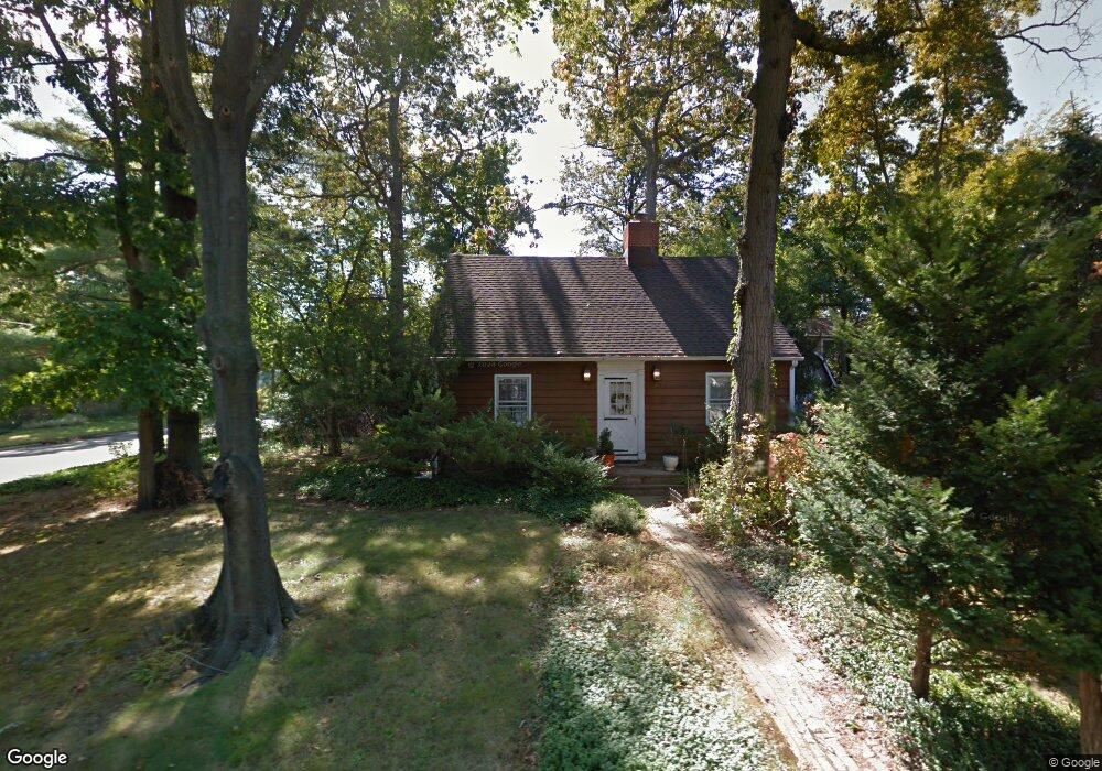
706 Carol Ave Oakhurst, NJ 07755
Estimated Value: $556,000 - $721,000
3
Beds
2
Baths
1,372
Sq Ft
$491/Sq Ft
Est. Value
About This Home
This home is located at 706 Carol Ave, Oakhurst, NJ 07755 and is currently estimated at $674,324, approximately $491 per square foot. 706 Carol Ave is a home located in Monmouth County with nearby schools including Ocean Township High School, Bet Yaakov of the Jersey Shore, and Yeshivat Keter Torah.
Ownership History
Date
Name
Owned For
Owner Type
Purchase Details
Closed on
Dec 15, 2011
Sold by
Jester Thomas J and Jester Timothy P
Bought by
Jester Thomas J
Current Estimated Value
Purchase Details
Closed on
Apr 28, 2009
Sold by
Jester Irina Samoilova
Bought by
Jester Thomas John
Purchase Details
Closed on
Jul 31, 1997
Sold by
Loizos Nikolaos
Bought by
Jester Thomas
Home Financials for this Owner
Home Financials are based on the most recent Mortgage that was taken out on this home.
Original Mortgage
$85,000
Outstanding Balance
$12,696
Interest Rate
7.5%
Estimated Equity
$661,628
Create a Home Valuation Report for This Property
The Home Valuation Report is an in-depth analysis detailing your home's value as well as a comparison with similar homes in the area
Home Values in the Area
Average Home Value in this Area
Purchase History
| Date | Buyer | Sale Price | Title Company |
|---|---|---|---|
| Jester Thomas J | -- | None Available | |
| Jester Thomas John | -- | None Available | |
| Jester Thomas | $120,000 | -- |
Source: Public Records
Mortgage History
| Date | Status | Borrower | Loan Amount |
|---|---|---|---|
| Open | Jester Thomas | $85,000 |
Source: Public Records
Tax History Compared to Growth
Tax History
| Year | Tax Paid | Tax Assessment Tax Assessment Total Assessment is a certain percentage of the fair market value that is determined by local assessors to be the total taxable value of land and additions on the property. | Land | Improvement |
|---|---|---|---|---|
| 2025 | $7,042 | $565,200 | $466,000 | $99,200 |
| 2024 | $7,575 | $493,800 | $406,000 | $87,800 |
| 2023 | $7,575 | $495,400 | $410,000 | $85,400 |
| 2022 | $6,117 | $401,300 | $320,000 | $81,300 |
| 2021 | $6,117 | $311,300 | $240,000 | $71,300 |
| 2020 | $6,499 | $326,400 | $240,000 | $86,400 |
| 2019 | $6,290 | $308,500 | $220,000 | $88,500 |
| 2018 | $6,489 | $309,900 | $215,000 | $94,900 |
| 2017 | $7,386 | $351,200 | $215,000 | $136,200 |
| 2016 | $5,969 | $255,300 | $170,000 | $85,300 |
| 2015 | $6,075 | $263,100 | $180,000 | $83,100 |
| 2014 | $6,444 | $282,900 | $200,000 | $82,900 |
Source: Public Records
Map
Nearby Homes
- 710 Dow Ave
- 1904 Waverly St
- 1903 Melville St
- 130 Woolley Ct
- 2025 Lesser Pkwy
- 6 Lotus Ct
- 55 Cotswold Cir
- 4 Rothbury Ct
- 18 Branch Rd
- 116 Cotswold Cir
- 6 Arlington St
- 123 Woolley Ct
- 27 Branch Rd
- 30 Oak Mews Ct Unit 4
- 179 Woolley Ct
- 120 Whalepond Rd
- 471 W Park Ave
- 186 Whalepond Rd
- 149 Jefferson Dr
- 155 Jefferson Dr
- 708 Carol Ave
- 1907 Holbrook St
- 705 Carol Ave
- 2001 Holbrook St
- 704 Carol Ave
- 1905 Holbrook St
- 2001 Finderne St
- 710 Carol Ave
- 2002 Finderne St
- 2003 Holbrook St
- 1910 Holbrook St
- 1907 Finderne St
- 709 Carol Ave
- 700 Carol Ave
- 1904 Finderne St
- 1906 Holbrook St
- 2003 Finderne St
- 1906 Fanwood St
- 701 Carol Ave
- 2002 Holbrook St