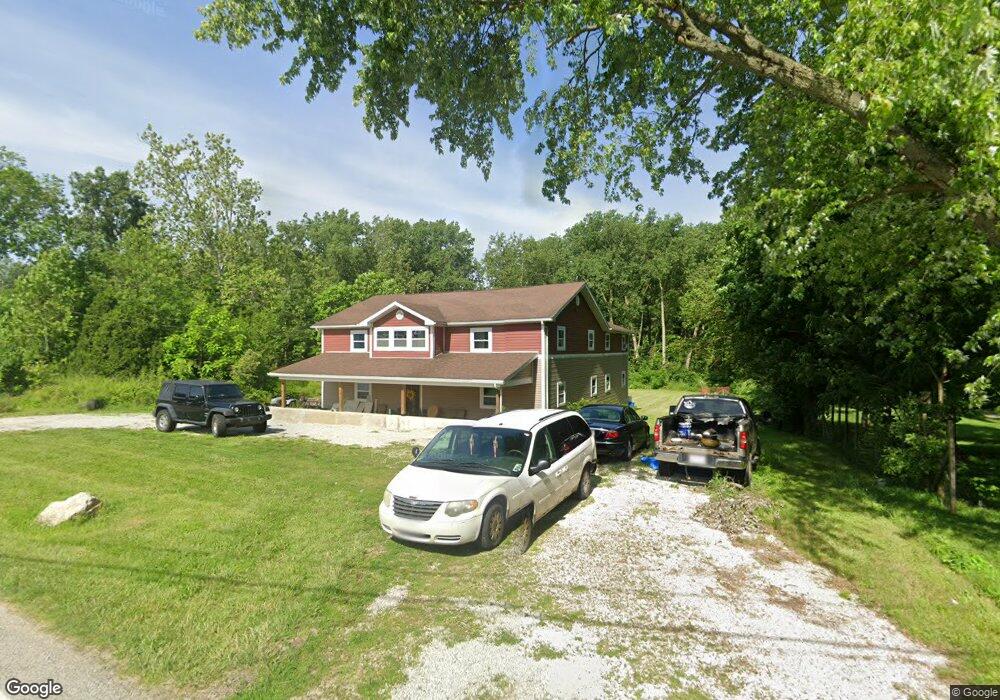
706 S State Route 19 Fremont, OH 43420
Estimated Value: $166,880 - $222,000
5
Beds
3
Baths
3,530
Sq Ft
$55/Sq Ft
Est. Value
About This Home
This home is located at 706 S State Route 19, Fremont, OH 43420 and is currently estimated at $194,470, approximately $55 per square foot. 706 S State Route 19 is a home located in Sandusky County with nearby schools including Clyde High School, Temple Christian Academy, and Sacred Heart School.
Ownership History
Date
Name
Owned For
Owner Type
Purchase Details
Closed on
Jan 31, 2023
Sold by
Pasch Miranda
Bought by
Sanders Bridget
Current Estimated Value
Home Financials for this Owner
Home Financials are based on the most recent Mortgage that was taken out on this home.
Original Mortgage
$180,000
Outstanding Balance
$174,332
Interest Rate
6.31%
Mortgage Type
New Conventional
Estimated Equity
$20,138
Purchase Details
Closed on
Apr 10, 2019
Sold by
Garcia Armonee
Bought by
Pasch Miranda
Purchase Details
Closed on
Aug 21, 2017
Sold by
Tucker Travis J
Bought by
Garcia Armonee
Purchase Details
Closed on
Sep 27, 2012
Sold by
Fannie Mae
Bought by
Tucker Travis J
Purchase Details
Closed on
Jul 9, 2012
Sold by
Silva Emilie
Bought by
Federal National Mortgage Association
Create a Home Valuation Report for This Property
The Home Valuation Report is an in-depth analysis detailing your home's value as well as a comparison with similar homes in the area
Home Values in the Area
Average Home Value in this Area
Purchase History
| Date | Buyer | Sale Price | Title Company |
|---|---|---|---|
| Sanders Bridget | $175,000 | -- | |
| Pasch Miranda | -- | None Available | |
| Garcia Armonee | -- | Attorney | |
| Tucker Travis J | $14,000 | Nova Title Agency Inc | |
| Federal National Mortgage Association | $64,000 | Attorney |
Source: Public Records
Mortgage History
| Date | Status | Borrower | Loan Amount |
|---|---|---|---|
| Open | Sanders Bridget | $180,000 |
Source: Public Records
Tax History Compared to Growth
Tax History
| Year | Tax Paid | Tax Assessment Tax Assessment Total Assessment is a certain percentage of the fair market value that is determined by local assessors to be the total taxable value of land and additions on the property. | Land | Improvement |
|---|---|---|---|---|
| 2024 | $1,530 | $40,920 | $9,800 | $31,120 |
| 2023 | $1,530 | $24,190 | $7,840 | $16,350 |
| 2022 | $1,015 | $24,190 | $7,840 | $16,350 |
| 2021 | $1,026 | $24,190 | $7,840 | $16,350 |
| 2020 | $858 | $19,530 | $7,840 | $11,690 |
| 2019 | $910 | $20,970 | $7,840 | $13,130 |
| 2018 | $910 | $20,970 | $7,840 | $13,130 |
| 2017 | $850 | $19,570 | $7,840 | $11,730 |
| 2016 | $837 | $17,850 | $7,840 | $10,010 |
| 2015 | $754 | $17,850 | $7,840 | $10,010 |
| 2014 | $804 | $18,100 | $7,810 | $10,290 |
| 2013 | $1,316 | $30,320 | $7,810 | $22,510 |
Source: Public Records
Map
Nearby Homes
- 2314 E Sr 20
- 0 Cr 214 Unit 20253055
- 1014 S County Road 198
- V/L County Road 220
- 0 County Road 220
- 2248 E State St
- 199 Saint Thomas Dr
- 251 Saint Paul Dr
- 263 Saint Paul Dr
- 474 N Co Road 204
- 1739 E State St Unit 23
- 315 Ethan Dr
- 318 Ethan Dr
- 1526 Sunrise Blvd
- 800 Lawndale Dr
- 546 Oaklawn Ave
- 131 Berkshire Dr
- 335 Cottage St
- 309 S Collinwood Blvd
- 230 N Pennsylvania Ave
- 706 Ohio 19
- 700 S State Route 19
- 700 Ohio 19
- 705 S State Route 19
- 714 S State Route 19
- 688 S State Route 19
- 748 S State Route 19
- 748 Ohio 19
- 681 S State Route 19
- 671 S State Route 19
- 661 S State Route 19
- 651 S State Route 19
- 634 County Road 358
- 636 S State Route 19
- 641 S State Route 19
- 616 County Road 358
- 631 S State Route 19
- 358 Cr
- 358 Cr
- 621 S State Route 19