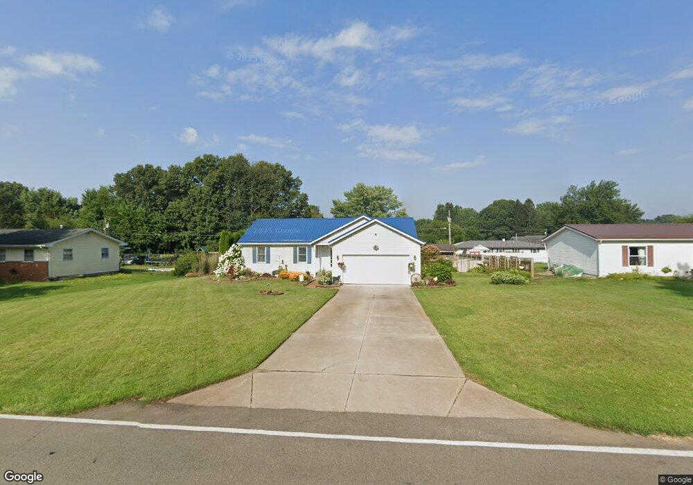
70642 Sherman Rd Edwardsburg, MI 49112
Estimated Value: $225,000 - $270,000
3
Beds
2
Baths
1,204
Sq Ft
$205/Sq Ft
Est. Value
About This Home
This home is located at 70642 Sherman Rd, Edwardsburg, MI 49112 and is currently estimated at $246,853, approximately $205 per square foot. 70642 Sherman Rd is a home located in Cass County with nearby schools including Edwardsburg Primary School, Eagle Lake Elementary School, and Edwardsburg Intermediate School.
Ownership History
Date
Name
Owned For
Owner Type
Purchase Details
Closed on
Jun 15, 2023
Sold by
Rl Gold Llc
Bought by
Moreno Chad and Moreno Heather
Current Estimated Value
Home Financials for this Owner
Home Financials are based on the most recent Mortgage that was taken out on this home.
Original Mortgage
$180,500
Outstanding Balance
$162,285
Interest Rate
5.76%
Mortgage Type
New Conventional
Estimated Equity
$84,568
Purchase Details
Closed on
Nov 23, 2021
Sold by
Holt Larry W and Holt Elena D
Bought by
Rl Gold Llc
Create a Home Valuation Report for This Property
The Home Valuation Report is an in-depth analysis detailing your home's value as well as a comparison with similar homes in the area
Home Values in the Area
Average Home Value in this Area
Purchase History
| Date | Buyer | Sale Price | Title Company |
|---|---|---|---|
| Moreno Chad | $190,000 | None Listed On Document | |
| Moreno Chad | $190,000 | None Listed On Document | |
| Rl Gold Llc | $125,000 | Accommodation |
Source: Public Records
Mortgage History
| Date | Status | Borrower | Loan Amount |
|---|---|---|---|
| Open | Moreno Chad | $180,500 | |
| Closed | Moreno Chad | $180,500 |
Source: Public Records
Tax History Compared to Growth
Tax History
| Year | Tax Paid | Tax Assessment Tax Assessment Total Assessment is a certain percentage of the fair market value that is determined by local assessors to be the total taxable value of land and additions on the property. | Land | Improvement |
|---|---|---|---|---|
| 2025 | $3,066 | $120,900 | $120,900 | $0 |
| 2024 | $1,217 | $115,300 | $115,300 | $0 |
| 2023 | $988 | $99,300 | $0 | $0 |
| 2022 | $941 | $89,000 | $0 | $0 |
| 2021 | $1,544 | $81,800 | $0 | $0 |
| 2020 | $1,534 | $73,000 | $0 | $0 |
| 2019 | $1,481 | $68,100 | $0 | $0 |
| 2018 | $579 | $62,100 | $0 | $0 |
| 2017 | $567 | $53,900 | $0 | $0 |
| 2016 | $562 | $54,300 | $0 | $0 |
| 2015 | -- | $55,300 | $0 | $0 |
| 2011 | -- | $56,000 | $0 | $0 |
Source: Public Records
Map
Nearby Homes
- 26049 Driftwood Dr
- 70574 N Driftwood Dr
- 26356 Redfield St
- 25590 Redfield St
- 71116 Meadow Dr
- 71353 State Line Rd
- 70866 Oak St
- 71599 State Line Rd
- 70275 Sheridan Dr
- 70293 Sheridan Dr
- 15 Ashley Rd
- 50590 Deer Ridge Ct
- 17 Ashley Rd
- 13 Ashley Rd
- 12 Ashley Rd
- 19 Ashley Rd
- 1 Ashley Rd
- 39 Tiffany Dr
- 38 Tiffany Dr
- 37 Tiffany Dr
- 70630 Sherman Rd
- 70666 Sherman Rd
- 70647 N Driftwood Dr
- 70627 N Driftwood Dr
- 70667 N Driftwood Dr
- 70684 Sherman Rd
- 70609 N Driftwood Dr
- 70695 N Driftwood Dr
- 70706 Sherman Rd
- 70590 Sherman Rd
- 70699 N Driftwood Dr
- 70583 N Driftwood Dr
- 70736 Sherman Rd
- 70606 N Driftwood Dr
- 70682 N Driftwood Dr
- 70682 N Driftwood Dr
- 70741 N Driftwood Dr
- 0 Keely Dr
- VL Keely Dr
- 70584 N Driftwood Dr