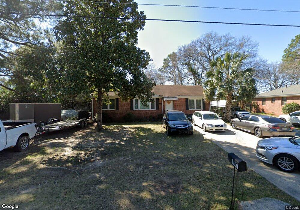
707 Bernard Dr Warner Robins, GA 31093
Estimated Value: $141,000 - $152,000
3
Beds
1
Bath
1,316
Sq Ft
$112/Sq Ft
Est. Value
About This Home
This home is located at 707 Bernard Dr, Warner Robins, GA 31093 and is currently estimated at $147,133, approximately $111 per square foot. 707 Bernard Dr is a home located in Houston County with nearby schools including Westside Elementary School, Northside Middle School, and Northside High School.
Ownership History
Date
Name
Owned For
Owner Type
Purchase Details
Closed on
Aug 3, 2010
Sold by
Gordon Charles Mark
Bought by
Robinson Sandra Ann
Current Estimated Value
Home Financials for this Owner
Home Financials are based on the most recent Mortgage that was taken out on this home.
Original Mortgage
$67,096
Outstanding Balance
$44,714
Interest Rate
4.7%
Mortgage Type
FHA
Estimated Equity
$102,419
Purchase Details
Closed on
Jun 24, 1999
Sold by
Bell Dorothy C
Bought by
Pender Carolyn B
Purchase Details
Closed on
Mar 11, 1999
Sold by
Payton Lillie Maude
Bought by
Bell Dorothy C
Purchase Details
Closed on
May 20, 1965
Sold by
Payton Chester C
Bought by
Payton Lillie Maude
Purchase Details
Closed on
Feb 16, 1960
Bought by
Payton Chester C
Create a Home Valuation Report for This Property
The Home Valuation Report is an in-depth analysis detailing your home's value as well as a comparison with similar homes in the area
Home Values in the Area
Average Home Value in this Area
Purchase History
| Date | Buyer | Sale Price | Title Company |
|---|---|---|---|
| Robinson Sandra Ann | $68,000 | None Available | |
| Pender Carolyn B | $50,000 | -- | |
| Bell Dorothy C | -- | -- | |
| Payton Lillie Maude | -- | -- | |
| Payton Chester C | -- | -- |
Source: Public Records
Mortgage History
| Date | Status | Borrower | Loan Amount |
|---|---|---|---|
| Open | Robinson Sandra Ann | $67,096 |
Source: Public Records
Tax History
| Year | Tax Paid | Tax Assessment Tax Assessment Total Assessment is a certain percentage of the fair market value that is determined by local assessors to be the total taxable value of land and additions on the property. | Land | Improvement |
|---|---|---|---|---|
| 2024 | $1,076 | $34,280 | $4,360 | $29,920 |
| 2023 | $916 | $29,160 | $4,360 | $24,800 |
| 2022 | $570 | $26,800 | $4,360 | $22,440 |
| 2021 | $496 | $23,440 | $4,360 | $19,080 |
| 2020 | $499 | $23,480 | $4,360 | $19,120 |
| 2019 | $545 | $23,480 | $4,360 | $19,120 |
| 2018 | $545 | $23,480 | $4,360 | $19,120 |
| 2017 | $546 | $23,480 | $4,360 | $19,120 |
| 2016 | $547 | $23,480 | $4,360 | $19,120 |
| 2015 | -- | $23,480 | $4,360 | $19,120 |
| 2014 | -- | $23,480 | $4,360 | $19,120 |
| 2013 | -- | $26,880 | $4,360 | $22,520 |
Source: Public Records
Map
Nearby Homes
- 717 Bernard Dr
- 800 N Briarcliff Rd
- 306 Woodlawn Ave
- 133 Briardale Ave
- 118 Briardale Ave
- 110 Springdale Dr
- 205 Lois Dr
- 119 Woodlawn Ave
- 118 Meadowcliff Cir
- 110 Briardale Ave
- 504 Sunset Dr
- 111 Marilyn Dr
- 203 Springdale Dr
- 402 & 404 Green St
- 103 Spring St
- 216 Pine Valley Dr
- 94 Ravenwood Way
- 213 Briarcliff Rd
- 102 Williams St
- 80 Ravenwood Way
- 709 Bernard Dr
- 705 Bernard Dr
- 711 Bernard Dr
- 703 Bernard Dr
- 117 Stantom Place
- 116 Stantom Place
- 713 Bernard Dr
- 710 Bernard Dr
- 701 Bernard Dr
- 119 Stantom Place Unit 9
- 119 Stantom Place
- 702 Bernard Dr
- 139 Lakeview Terrace
- 712 Bernard Dr
- 1822 Watson Blvd
- 715 Bernard Dr
- 115 Hickory St
- 113 Hickory St
- 144 Lakeview Terrace
- 117 Hickory St
Your Personal Tour Guide
Ask me questions while you tour the home.