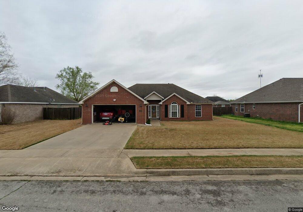
707 Herron St Prairie Grove, AR 72753
Estimated Value: $287,205 - $312,000
3
Beds
2
Baths
1,644
Sq Ft
$181/Sq Ft
Est. Value
About This Home
This home is located at 707 Herron St, Prairie Grove, AR 72753 and is currently estimated at $298,301, approximately $181 per square foot. 707 Herron St is a home located in Washington County with nearby schools including Prairie Grove Elementary School, Prairie Grove Middle School, and Prairie Grove Junior High School.
Ownership History
Date
Name
Owned For
Owner Type
Purchase Details
Closed on
Aug 10, 2011
Sold by
Silvis Lonnie and Silvis Becky
Bought by
Silvis Lonnie and Silvis Becky
Current Estimated Value
Purchase Details
Closed on
Jul 27, 2011
Sold by
Mayes Bone Steve
Bought by
Silvis Becky and Silvis Lonnie
Purchase Details
Closed on
Apr 19, 2006
Sold by
Mayes Richard Myron and Mayes Evelyn Dolores
Bought by
Mayes Richard Myron and Mayes Evelyn Dolores
Purchase Details
Closed on
Jun 11, 2004
Sold by
Johnson Margaret Jeanette
Bought by
Mayes Richard M and Mayes Dolores
Create a Home Valuation Report for This Property
The Home Valuation Report is an in-depth analysis detailing your home's value as well as a comparison with similar homes in the area
Home Values in the Area
Average Home Value in this Area
Purchase History
| Date | Buyer | Sale Price | Title Company |
|---|---|---|---|
| Silvis Lonnie | -- | None Available | |
| Silvis Becky | -- | None Available | |
| Mayes Richard Myron | -- | None Available | |
| Mayes Richard M | $144,000 | Waco Title Company |
Source: Public Records
Tax History Compared to Growth
Tax History
| Year | Tax Paid | Tax Assessment Tax Assessment Total Assessment is a certain percentage of the fair market value that is determined by local assessors to be the total taxable value of land and additions on the property. | Land | Improvement |
|---|---|---|---|---|
| 2025 | $925 | $51,830 | $8,000 | $43,830 |
| 2024 | $1,049 | $51,830 | $8,000 | $43,830 |
| 2023 | $1,183 | $51,830 | $8,000 | $43,830 |
| 2022 | $1,608 | $29,780 | $6,000 | $23,780 |
| 2021 | $1,608 | $29,780 | $6,000 | $23,780 |
| 2020 | $1,476 | $29,780 | $6,000 | $23,780 |
| 2019 | $1,357 | $24,940 | $4,000 | $20,940 |
| 2018 | $1,357 | $24,940 | $4,000 | $20,940 |
| 2017 | $1,344 | $24,940 | $4,000 | $20,940 |
| 2016 | $1,344 | $24,940 | $4,000 | $20,940 |
| 2015 | $1,344 | $24,940 | $4,000 | $20,940 |
| 2014 | $1,408 | $26,130 | $4,000 | $22,130 |
Source: Public Records
Map
Nearby Homes
- 703 Grant Ave
- 806 Grant Ave
- 110 Cypress St
- 813 Grant Ave
- 807 Sedgwick Dr
- 815 Custer St
- 818 Grant Ave
- 816 Custer St
- 661 Summer Ln
- 601 Pennington Ave
- 301 Hindman Dr
- 0 S Industrial Park Rd
- 950 Snyder Grove Dr
- 111 W Cleveland St
- 311 S Mock St
- 5.56+/- AC Tract 2 Hwy 62 & S Mock St
- 201 E Cleveland St
- 4.66 +/- AC Tract 5 Hwy 62 & S Mock St
- 211 Boston St
- 1650 Plan at Wagnon Springs