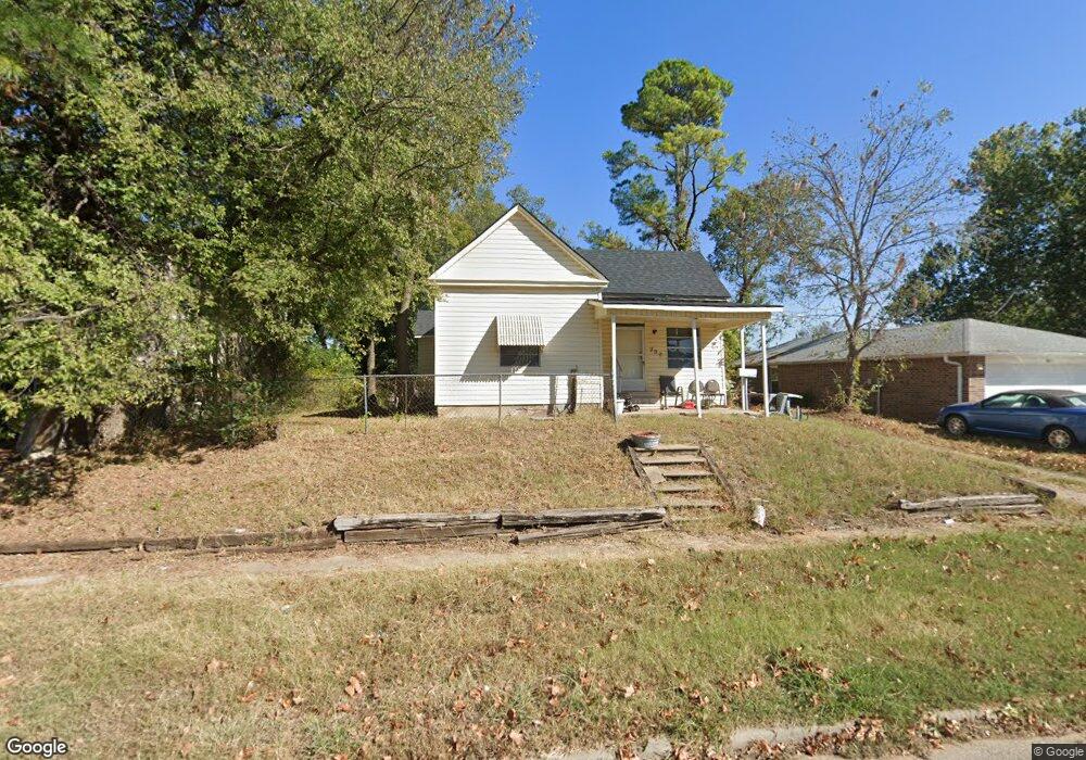
707 Hobson St Shawnee, OK 74801
Estimated Value: $51,000 - $116,000
3
Beds
1
Bath
1,024
Sq Ft
$74/Sq Ft
Est. Value
About This Home
This home is located at 707 Hobson St, Shawnee, OK 74801 and is currently estimated at $75,934, approximately $74 per square foot. 707 Hobson St is a home located in Pottawatomie County with nearby schools including Sequoyah Elementary School, Shawnee Middle School, and Shawnee High School.
Ownership History
Date
Name
Owned For
Owner Type
Purchase Details
Closed on
Jul 9, 2025
Sold by
Mrz Lizzies Home Rentals Llc
Bought by
Mrz Lizzies Home Rentals Llc
Current Estimated Value
Purchase Details
Closed on
Nov 1, 2016
Sold by
Maxwell Johnie F and Maxwell Tyler A
Bought by
Maxwell Johnie F
Purchase Details
Closed on
Aug 23, 2016
Sold by
Wallace John S and Wallace Dorena L
Bought by
Kaye Steele Harrod Family Trust
Purchase Details
Closed on
Mar 26, 2013
Sold by
Maxwell Johnie F
Bought by
Maxwell Johnie F and Maxwell Tyler A
Purchase Details
Closed on
Jan 29, 1996
Sold by
Howard Frank
Bought by
Wallace John and Wallace Victoria
Create a Home Valuation Report for This Property
The Home Valuation Report is an in-depth analysis detailing your home's value as well as a comparison with similar homes in the area
Home Values in the Area
Average Home Value in this Area
Purchase History
| Date | Buyer | Sale Price | Title Company |
|---|---|---|---|
| Mrz Lizzies Home Rentals Llc | -- | None Listed On Document | |
| Maxwell Johnie F | -- | None Available | |
| Kaye Steele Harrod Family Trust | $24,000 | None Available | |
| Maxwell Johnie F | -- | None Available | |
| Wallace John | $12,000 | -- |
Source: Public Records
Tax History Compared to Growth
Tax History
| Year | Tax Paid | Tax Assessment Tax Assessment Total Assessment is a certain percentage of the fair market value that is determined by local assessors to be the total taxable value of land and additions on the property. | Land | Improvement |
|---|---|---|---|---|
| 2024 | $365 | $3,670 | $592 | $3,078 |
| 2023 | $365 | $3,495 | $592 | $2,903 |
| 2022 | $342 | $3,329 | $592 | $2,737 |
| 2021 | $319 | $3,170 | $1,176 | $1,994 |
| 2020 | $320 | $3,170 | $1,176 | $1,994 |
| 2019 | $331 | $3,170 | $1,176 | $1,994 |
| 2018 | $309 | $3,024 | $1,176 | $1,848 |
| 2017 | $291 | $2,880 | $1,176 | $1,704 |
| 2016 | $319 | $3,122 | $538 | $2,584 |
| 2015 | $297 | $2,973 | $505 | $2,468 |
| 2014 | $283 | $2,831 | $454 | $2,377 |
Source: Public Records
Map
Nearby Homes
- 717 N Broadway Ave
- 727 N Beard Ave
- 434 E Wallace St
- 1017 N Bdwy Ave
- 735 N Park Ave
- 1003 N Minnesota Ave
- 128 W Ridgewood St
- 317 W Dill St
- 320 W Dill St
- 1006 N Market Ave
- 318 W Dill St
- 615 N Park Ave
- 730 N Tucker Ave
- 634 N Louisa Ave
- 710 N Tucker Ave
- 426 N Beard Ave
- 810 N Kickapoo Ave
- 509 N Park Ave
- 1217 N Market Ave
- 000 N Mckinley Ave
- 709 Hobson St
- 707 N Hobson Ave
- 701 N Hobson Ave
- 110 E Dewey St
- 711 Hobson St
- 715 Hobson St
- 112 E Dewey St
- 718 N Hobson Ave
- 718 N Hobson Ave
- 708 N Union Ave
- 710 N Union Ave
- 721 Hobson St
- 639 Hobson St
- 115 E Dewey St
- 716 N Union Ave
- 702 N Union Ave
- 718 N Union Ave
- 706 Hobson St
- 704 N Hobson Ave
- 712 Hobson St