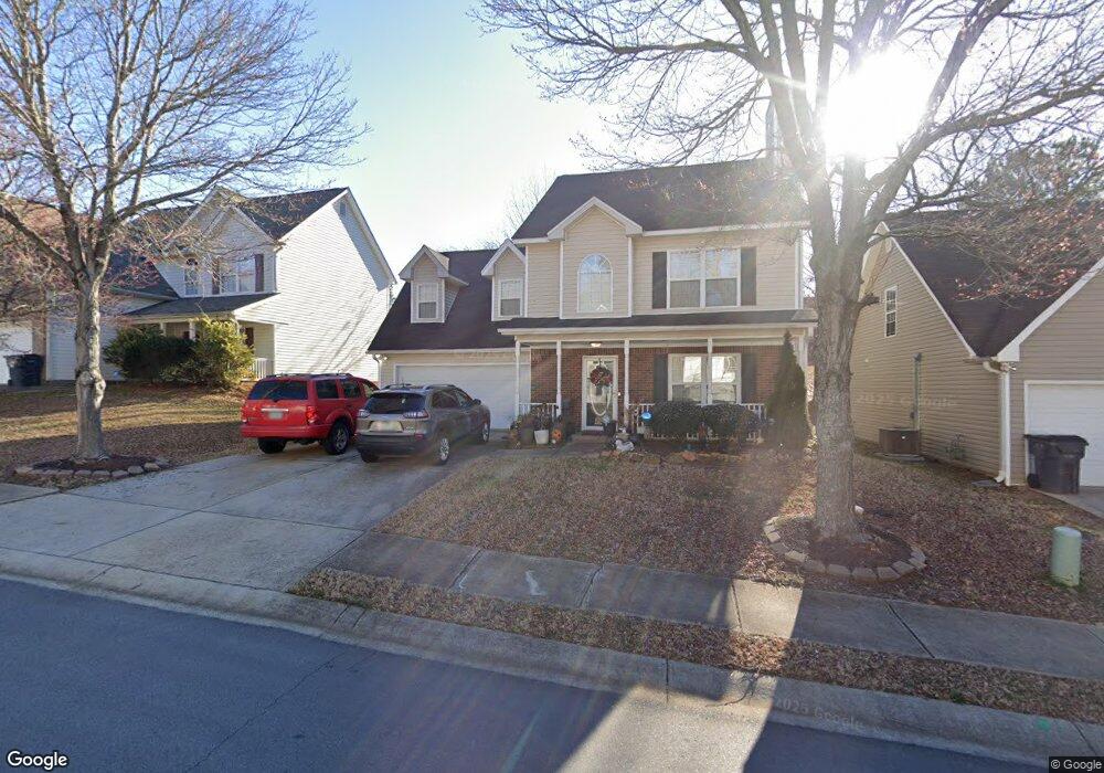
707 Patriot's Point St Locust Grove, GA 30248
Estimated Value: $257,000 - $262,945
3
Beds
3
Baths
1,813
Sq Ft
$143/Sq Ft
Est. Value
About This Home
This home is located at 707 Patriot's Point St, Locust Grove, GA 30248 and is currently estimated at $259,986, approximately $143 per square foot. 707 Patriot's Point St is a home located in Henry County with nearby schools including Locust Grove Elementary School, Locust Grove Middle School, and Locust Grove High School.
Ownership History
Date
Name
Owned For
Owner Type
Purchase Details
Closed on
Oct 18, 2018
Sold by
Roberts Eleanora
Bought by
Martin Terri L and Martin Robert A
Current Estimated Value
Purchase Details
Closed on
Feb 28, 2003
Sold by
Walden Custom Homes Inc
Bought by
Roberts Eleanora
Home Financials for this Owner
Home Financials are based on the most recent Mortgage that was taken out on this home.
Original Mortgage
$129,074
Interest Rate
5.89%
Mortgage Type
New Conventional
Create a Home Valuation Report for This Property
The Home Valuation Report is an in-depth analysis detailing your home's value as well as a comparison with similar homes in the area
Home Values in the Area
Average Home Value in this Area
Purchase History
| Date | Buyer | Sale Price | Title Company |
|---|---|---|---|
| Martin Terri L | $152,000 | -- | |
| Roberts Eleanora | $131,000 | -- |
Source: Public Records
Mortgage History
| Date | Status | Borrower | Loan Amount |
|---|---|---|---|
| Previous Owner | Roberts Eleanora | $129,074 |
Source: Public Records
Tax History Compared to Growth
Tax History
| Year | Tax Paid | Tax Assessment Tax Assessment Total Assessment is a certain percentage of the fair market value that is determined by local assessors to be the total taxable value of land and additions on the property. | Land | Improvement |
|---|---|---|---|---|
| 2025 | $485 | $109,240 | $16,000 | $93,240 |
| 2024 | $485 | $109,480 | $16,000 | $93,480 |
| 2023 | $794 | $115,120 | $14,000 | $101,120 |
| 2022 | $800 | $93,680 | $14,000 | $79,680 |
| 2021 | $1,733 | $71,800 | $14,000 | $57,800 |
| 2020 | $1,542 | $63,720 | $10,000 | $53,720 |
| 2019 | $1,433 | $58,200 | $10,000 | $48,200 |
| 2018 | $0 | $50,080 | $7,600 | $42,480 |
| 2016 | $1,743 | $46,760 | $8,000 | $38,760 |
| 2015 | $1,674 | $43,320 | $8,000 | $35,320 |
| 2014 | $1,465 | $37,720 | $8,000 | $29,720 |
Source: Public Records
Map
Nearby Homes
- 220 Umber Rd
- 733 Myrica Ave
- 417 Hazel Dr
- 409 Hazel Dr
- 421 Hazel Dr
- 700 Patriots Point St
- 1321 Deutz Dr
- 23 Club Dr
- 0 Tanger Dr
- 14 Peeksville Rd
- 32 Peeksville Rd
- 1129 Abundance Dr
- 29 Indian Creek Rd
- 733 Jackson St
- 708 Curb Ct
- 648 Kimberwick Dr
- 805 Wetherford Ct
- Roswell Plan at Peeksville Landing
- Oakland Plan at Peeksville Landing
- Portland Plan at Peeksville Landing
- 707 Patriots Point St
- 705 Patriots Point St
- 709 Patriots Point St Unit 709
- 709 Patriots Point St
- 703 Patriots Point St
- 708 Patriot's Point St
- 711 Patriots Point St
- 110 Colony Park Ln
- 112 Colony Park Ln
- 118 Colony Park Ln
- 708 Patriots Point St
- 710 Patriots Point St
- 0 Colony Park Ln
- 712 Patriots Point St
- 706 Patriots Point St
- 124 Colony Park Ln
- 713 Patriots Point St
- 120 Colony Park Ln
- 120 Colony Park Ln Unit 4
- 714 Patriots Point St